This content was originally published by the Longmont Observer and is licensed under a Creative Commons license.
By John Ensworth
Special “Programming” note: I’ve traveled up into the path of totality on Saturday, returning Monday PM. I don’t know if the cell tower connections or if hotel/restaurant internet will still work as the rest of the nation joins me. I may miss my first forecasts yet in this column some of these days. Sorry!
Discussion:
(With limited bandwidth, and a quiet pattern, I’m only posting two example graphics in a quiet weather pattern.)
We have westerly flow aloft and dry conditions across Colorado. There was a cool front was moving down through Wyoming into the state Sunday. Temperatures will cool 5 degrees today over yesterday. Behind the front today, a bit of upslope flow and moisture coming in from the east will create a small chance of rain in the foothills then eastward in the afternoon. This will create a fair amount of cloudiness for many during the eclipse. (Note, the cloud forecast for Wyoming and Nebraska for the eclipse is in a special section below.)
Figure 1 shows the front approaching northern Colorado on Sunday.
Figure 1: The Sunday surface analysis map with infrared satellite background.

The surface forecast map shows a chance of rain Monday morning from northern Colorado up into Nebraska. The post frontal air in Wyoming is mostly cloud and precipitation chances free. Figure 2 and 3.
Figure 2: The NCEP surface frontal analysis and precipitation chances forecast map for Monday morning.

Figure 3: The GFS forecasted surface precipitation map for Monday evening. The purple line is a rough depiction of the eclipse path.

In a look at the longer range:
After the eclipse, we’ll look at a few additional cool fronts, a return to below normal temperatures for this time of year and a tapping of southern (monsoon like) moisture. More on that later.
_________________________________________________________
Eclipse forecast special:
We continue to build a trend chart here for a sampling of eclipse viewing locations. Each forecast will be for the expected % cloud cover (0% is clear, 100% is overcast) at 12pm Mountain Time for Teton Village, WY, Casper, WY, Glendo, WY, Lusk, WY, Alliance, NE, and Longmont, CO (Longmont is included for reference… it will NOT be in the totality path).
I’ll added day’s model forecast for that time from Sunday night to Sunday night. The important thing, now is the last column. A 24 hour cloud foreast is better than the prior forecast trends.
Monday commentary (issued 24 hours from the start of the eclipse): This is the best cloud forecast you’ll get from this column. If you need to see graphics right up to the eclipse, please visit the source site for all the data. The trend is towards a fair amount of clouds in western WY and some clouds in eastern WY with serious clear in-between. Nebraska is looking pretty cloudy. Looking for the western extent of the clouds, Torrington, WY is at 30% cloud cover and Lingle, WY = 33%. Mitchell, NE = 48%, Scottsbluff, NE = 48%.
| Percent Cloud Cover Forecasted for | Sun 8/13 | Mon 8/14 | Tue 8/15 | Wed 8/16 | Thur 8/17 | Fri 8/18 | Sat 8/19 | Sun 8/20 |
| Teton Village | 26% | 30% | 12% | 41% | 54% | 44% | 26% | 21% |
| Casper | 9% | 27% | 38% | 43% | 15% | 2% | 1% | 0% |
| Glendo | 13% | 31% | 33% | 38% | 24% | 8% | 4% | 6% |
| Lusk | 9% | 26% | 22% | 23% | 14% | 24% | 29% | 10% |
| Alliance | 7% | 36% | 39% | 37% | 23% | 36% | 78% | 70% |
| Longmont | 23% | 45% | 22% | 34% | 54% | 16% | 34% | 61% |
A Map Version of Cloud Forecasts
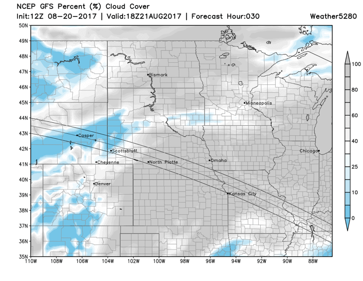
I’m dropping the trend graphics for this final forecast and am putting up the closest cloud product from every source I know of (some might be based on the same underlying model, but are a different representation).
Sunday commentary: Central Nebraska and east looks bad in almost all models. Western Nebraska is off and on between models. Most of Wyoming is in excellent or good shape for the eclipse. Areas around Casper are universally clear on all models. For the partial eclipse in Longmont, it is looking quite cloudy. The high sun angle will help people to get a glimpse now and then.
Forecasts created Sunday 8/20, 24 hours prior to the eclipse.
NCEP Forecast from Weather5280.com folks. Source: https://www.weather5280.com/models

Clear Sky Chart clouds from the Canadian Meteorological Center. Source: http://cleardarksky.com/csk/

North American Model clouds. Source: http://weather.rap.ucar.edu/model/

RAP model clouds. Source: http://weather.rap.ucar.edu/model/

Skippy Sky cloud forecast from Australia. Source: http://weather.rap.ucar.edu/model/ (I’ll include the entire eclipse path.)


Finally, you can get updated Pie Charts of clear skies from 7Timer http://202.127.24.18/wchart.php?lang=zh-CN7 - search for your city and click ASTRO forecast. This site is slow to load and doesn’t work at all sometimes.
(Example graphic for Lusk, WY- looks GREAT here! The red line is midnight between Sunday and Monday. 12 under the date is noon Monday.)

*** This feature will run as close to daily as possible in this location on the Longmont Observer. ***
This article will provide a brief discussion concerning the ‘why’ behind the weather with a focus on severe weather, unusual weather, and snow (especially trying to predict snow depth and its human impact in Longmont).
Bio:
John Ensworth works from Longmont as the Principle Investigator for the NASA Science Mission Directorate Earth and space science education product review through the IGES (The Institute for Global Environmental Strategies – www.strategies.org) . He is in his 14th year running this review. He is an astronomer (from the 2nd grade onward) and became a meteorologist (in the 5th grade) when a thunderstorm in Arizona rained on his telescope when the weather service had only forecasted a 10% chance of rain. He has college degrees in physics and astronomy and climatology and a graduate degree in meteorology and earth science. He lectures at the Little Thompson Observatory in Berthoud, the Estes Park Memorial Observatory in Estes Park, and for a number of online universities. He built and runs a backyard observatory near Pace and 17th in northeast Longmont where he has lived for 8 years with his wife, daughter, son, and two cats. Invitations to open house nights at this observatory, LTO, and EPMO will be posted with future discussions when they are scheduled.
Forecasting severe weather and snow amounts via text lead to this column. He began texting friends about the weather right after the September 2013 flood. The readers of this column will, hopefully, keep him honest in what he ‘thought’ he had forecasted for ‘the most recent’ storm.


