Skip to content

The Next Storm/Next Snow Forecast Discussion from the Cherrywood Observatory – October 1st, 2018

This content was originally published by the Longmont Observer and is licensed under a Creative Commons license.

Forecast Discussion:

Enjoy the last three days of late-summer weather.  It all ends this week.

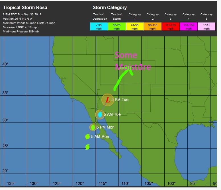
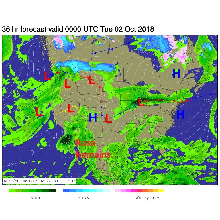
Figure 1 is the forecast surface map for today. Tropical Storm (soon to be downgraded) Rosa is mushing (yes "mushing") ashore in Mexico with rain pouring into Arizona and southern California. We have 'some' moisture already making it into western Colorado.  Models are showing the precipitatable water increasing every day this week until we are very moist by Wednesday.

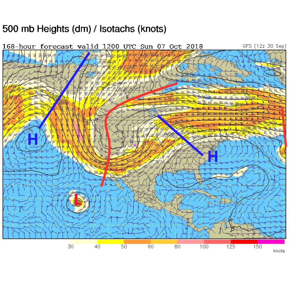
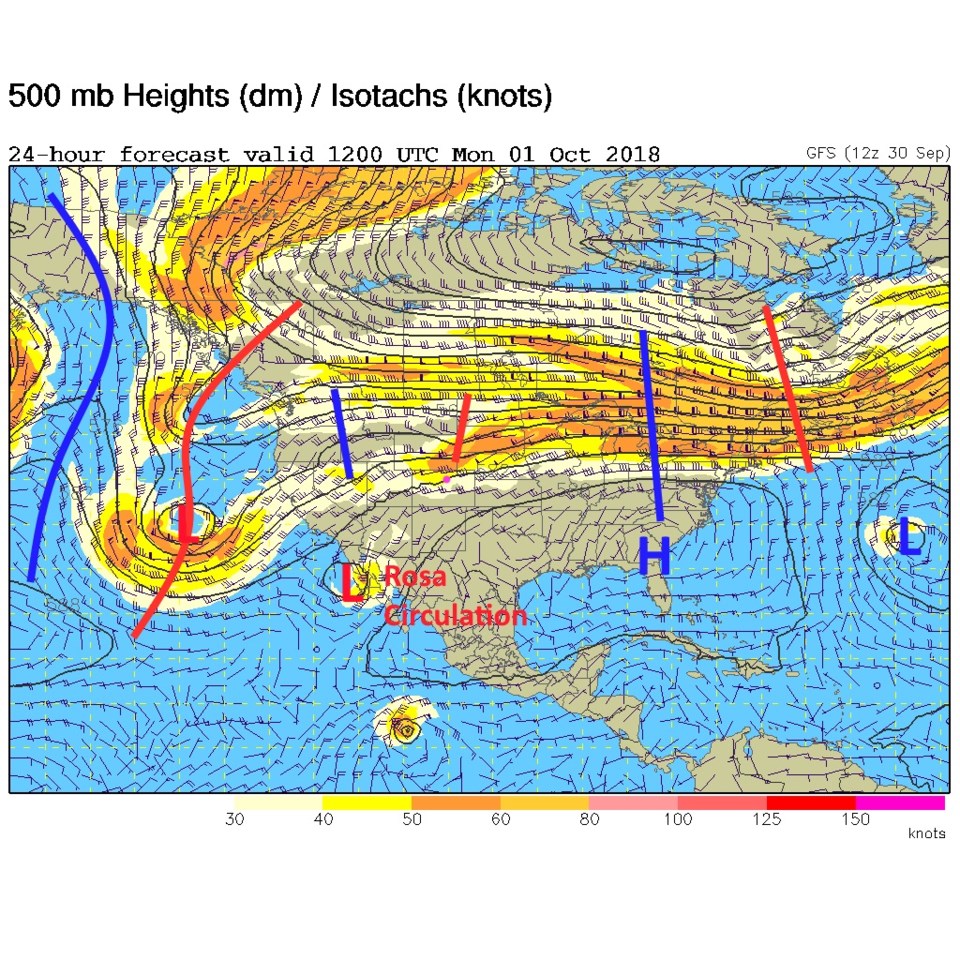
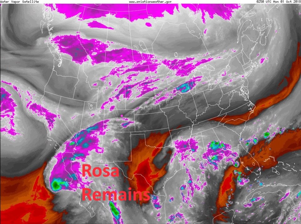
The face of change is the trough on the west coast. The ridge out in the Pacific will grow to become a giant, giving Alaska record heat, and transition us into late Fall/early Winter like weather (Figure 2).  Once you see the upper air pattern (Figure 2) - take a look at the water vapor image (Figure 3) and you can see the same pattern in the flow of dry and moist air.

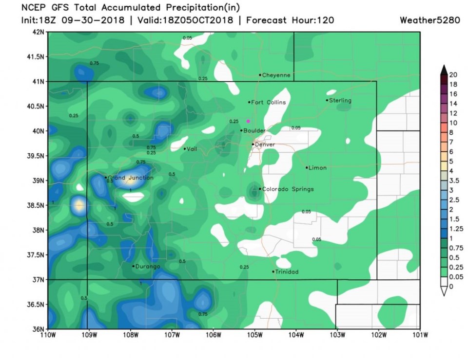
Over the next 5 days, the GFS "STILL" keeps us quite dry (only up to about 1/4 inch of rain) through Friday (Figure 4).  (More below in the longer range forecast...)

Figure 1: The forecast surface map for Monday PM. From NCEP.

Figure 2: The 500mb forecast upper air analysis for Monday AM. Pink dot is Longmont. Red lines are troughs, blue lines are ridges.

Figure 3: The visible satellite image from Sunday PM from NOAA

Figure 4: The total precipitation between Sunday PM and Friday noon from the GFS and weather5280.com

The longer range forecast:

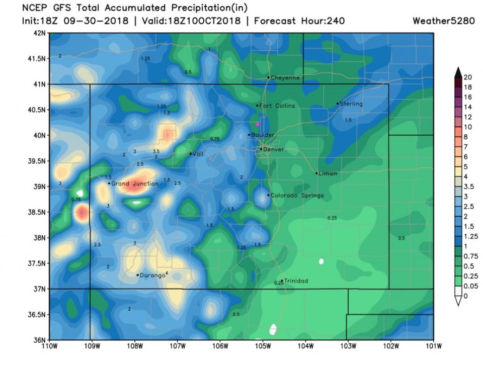
That trough in the west will grow and expand to dominate the western 1/2 of the nation (Figure 5). This means much cooler weather and greater rain chances. Looking at the GFS for the next 10 days (Figure 6) we approach 1 inch of rainfall over the next week plus.

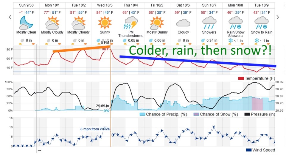
You can see the big picture in Figure 7.  We stay in the lower 80'sF through Wednesday when another, strong, front approaches and turns on the cold upslope-flow machine. Rain and thunderstorm chances return.  This model (different from the GFS) gives us a similar, roughly 1/10th inch of rain by the weekend. We go off the cliff Wednesday night.  Each day gets colder and rain chances slowly increase through next week.  And, yes, Virginia, there is snow in the forecast for NEXT Monday/Tuesday.  Nighttime temperatures drop below freezing about 9 to 10 days out as well.

Figure 8 is a final look at Rosa.  It should still be a tropical depression in central AZ Tuesday night.  The moisture that heads to the northeast will join our front later this week.  Where did you put your coat, gloves, boots, and hat last year...?

Figure 5: The 500mb forecast upper air analysis for Monday AM. Pink dot is Longmont. Red lines are troughs, blue lines are ridges.

Figure 6: The total precipitation for the next 10 days between Sunday PM and Wednesday 10/10 noon from the GFS and weather5280.com

Figure 7: the next 10 days of the graphical forecast for Longmont, CO from weatherunderground.com

Figure 8: The 5 day forecast track and intensity map for Hurricane Rosa from the NHC and weatherunderground.com

Current Weather

Cloudy

Cloudy

36°F

UV Index
1 Low
Pressure
30.22 Steady
Visibility
7 miles
Dewpoint
34 °F
Humidity
89%
Wind
NNE 3.8 mph
Gust
6.5 mph
Wind Chill
34 °F

Hourly Forecast

Today
11 AM
37°F
Flurries
Today
12 PM
38°F
Mostly cloudy
Today
1 PM
39°F
Intermittent clouds
Today
2 PM
40°F
Cloudy
Today
3 PM
41°F
Cloudy
Today
4 PM
42°F
Cloudy
Today
5 PM
40°F
Cloudy
Today
6 PM
39°F
Rain
Today
7 PM
38°F
Rain
Today
8 PM
37°F
Cloudy
Today
9 PM
35°F
Flurries
Today
10 PM
35°F
Cloudy

7 Day Forecast

Rain and snow

Friday

42 °F

Chilly with some sun, then turning cloudy; a couple of showers of rain or snow this morning followed by a little rain this afternoon


Rain and snow

Friday Night

32 °F

Periods of snow; rain mixed in early, accumulating 1-3 inches; roads could be slippery


Flurries

Saturday

39 °F

A bit of morning snow with little or no accumulation; otherwise, cloudy and chilly; storm total snowfall 1-3 inches


Intermittent clouds

Saturday Night

31 °F

A shower in places in the evening; otherwise, partly cloudy


Partly sunny

Sunday

64 °F

Partly sunny, pleasant and warmer


Mostly clear

Sunday Night

41 °F

Mainly clear


Intermittent clouds

Monday

79 °F

Warmer with a blend of sun and clouds


Partly cloudy

Monday Night

36 °F

Partly cloudy


Mostly cloudy

Tuesday

64 °F

Mostly cloudy and cooler


Mostly cloudy

Tuesday Night

40 °F

Mostly cloudy


Sunrise and Sunset

Sunrise
6:15 AM
Sunset
7:44 PM

Based on AccuWeather data