Skip to content

The Next Storm/Next Snow Forecast Discussion from the Cherrywood Observatory – October 18th, 2018

This content was originally published by the Longmont Observer and is licensed under a Creative Commons license.

Forecast Discussion:

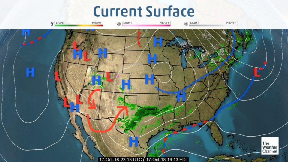
We had a few clouds move into NE Colorado in response to the low in the southwest today, but the sun was out and temperatures warmed (and snow melted). The main band of rain from this system is still over Texas (Figure 1).

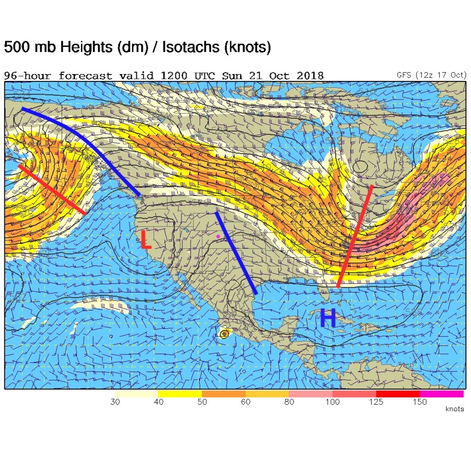
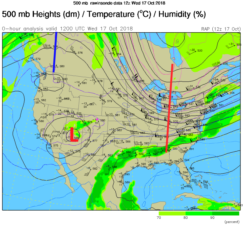
We have a fun phenomena to explore today... that of an interesting way the upper level low (over Arizona) can dissipate rather than propagate (travel) somewhere. We'll start with the upper level map at 500mb (Figure 2). The low center (cut-off low) is plainly visible over Flagstaff. Aside from that low, there is a big ridge over the western half of the nation with a deep trough digging into the east (making them cold AND deflecting hurricanes).

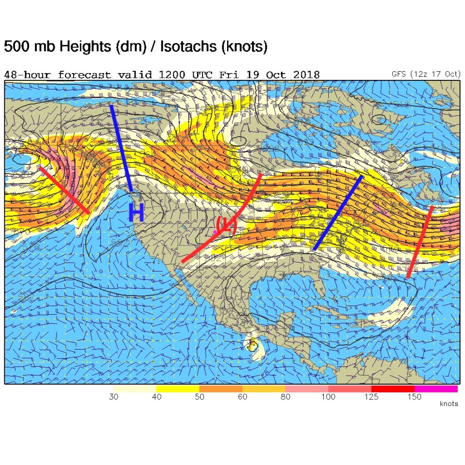
By tomorrow (Figure 3) the low is fading out and being absorbed into the jet stream flow (as northwest flow begins to set up over the state. More in the longer range below...

Figure 1: The current surface map for Wednesday afternoon from the Weather Channel.

Figure 2: The current surface map for Wednesday afternoon from NCAR/UCAR.

Figure 3: The 500mb forecast upper air analysis for Friday morning. Pink dot is Longmont. Red lines are troughs, blue lines are ridges.

The longer range forecast:

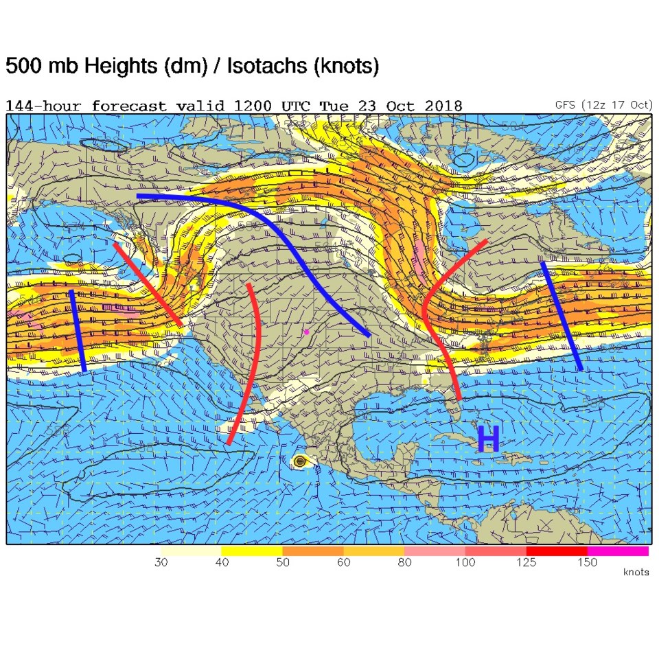
By Sunday (when we are at our warmest over the next 10 days - around 72°F) we have a southern portion of a big west coast ridge over the state. That low is gone. Another cut-off low is entering California (Figure 4).

Our next chance of rain (still small at this point) comes mid-week next week. Tuesday's upper-air map shows a trough approaching from the west again (Figure 5).

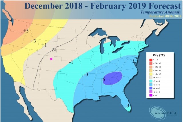
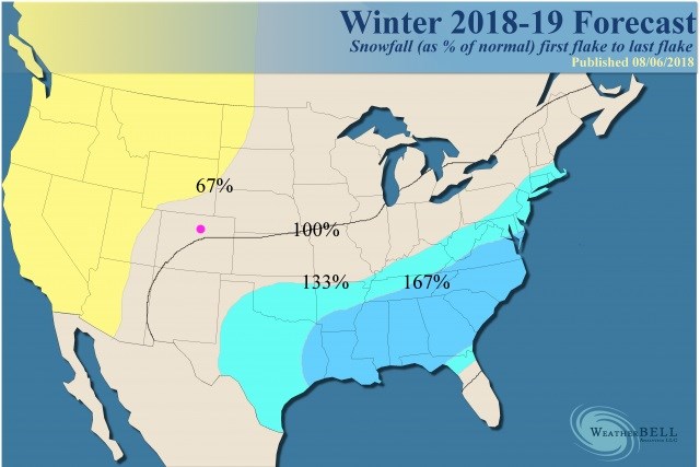
I thought I'd also feature the Weatherbell.com winter forecast (it is a great site, but its content is mostly behind a pay-wall; these are the public facing graphics only). They look at long range patterns and sea-surface temperature trends and the like to make their forecast. Figure 6 has unusual cold in the eastern and southeastern parts of the nation. We are just a bit colder than normal through February, if this is correct. Figure 7 is the snowfall potential/departure from normal. The southeastern U.S. will get a lot more snow than normal if this is correct. Longmont is near, or a touch below, normal snowfall.

Figure 4: The 500mb forecast upper air analysis for Sunday morning. Pink dot is Longmont. Red lines are troughs, blue lines are ridges.

Figure 5: The 500mb forecast upper air analysis for next Tuesday morning. Pink dot is Longmont. Red lines are troughs, blue lines are ridges.

Figure 6: The Weatherbell.com winter forecast for temperature departure from normal.

Figure 7: The Weatherbell.com winter forecast for snowfall departure from normal.

Current Weather

Cloudy

Cloudy

69°F

UV Index
3 Moderate
Pressure
29.59 Steady
Visibility
8 miles
Dewpoint
33 °F
Humidity
26%
Wind
WNW 5.5 mph
Gust
11.3 mph
Wind Chill
69 °F

Hourly Forecast

Today
2 PM
69°F
Thunderstorms
Today
3 PM
70°F
Intermittent clouds
Today
4 PM
68°F
Intermittent clouds
Today
5 PM
66°F
Mostly cloudy
Today
6 PM
61°F
Thunderstorms
Today
7 PM
58°F
Thunderstorms
Today
8 PM
56°F
Cloudy
Today
9 PM
53°F
Cloudy
Today
10 PM
51°F
Thunderstorms
Today
11 PM
49°F
Thunderstorms
Tomorrow
12 AM
48°F
Cloudy
Tomorrow
1 AM
48°F
Cloudy

7 Day Forecast

Mostly cloudy w/ t-storms

Friday

70 °F

Variable cloudiness; a morning shower in spots followed by a couple of thundershowers this afternoon; gusty winds and small hail can accompany any downpour


Thunderstorms

Friday Night

44 °F

Cloudy; a couple of showers and a thunderstorm this evening followed by periods of rain late; gusty winds and small hail can accompany any downpour


Rain

Saturday

47 °F

Chilly with periods of rain and a thunderstorm; travel in the foothills and mountains will be slippery due to snow


Rain and snow

Saturday Night

36 °F

Cloudy with rain, mixed with a little snow late; travel in the foothills and mountains will be slippery due to snow


Mostly cloudy

Sunday

61 °F

Mostly cloudy and warmer


Intermittent clouds

Sunday Night

36 °F

A thunderstorm in spots in the evening; otherwise, partly cloudy


Partly sunny

Monday

71 °F

Partly sunny, pleasant and warmer


Partly cloudy

Monday Night

45 °F

Partly cloudy


Mostly sunny

Tuesday

73 °F

Pleasant with sunshine and patchy clouds


Partly cloudy

Tuesday Night

43 °F

Partly cloudy


Sunrise and Sunset

Sunrise
6:06 AM
Sunset
7:51 PM

Based on AccuWeather data