Skip to content

The Next Storm/Next Snow Forecast Discussion from the Cherrywood Observatory – October 17th, 2018

This content was originally published by the Longmont Observer and is licensed under a Creative Commons license.

Forecast Discussion:

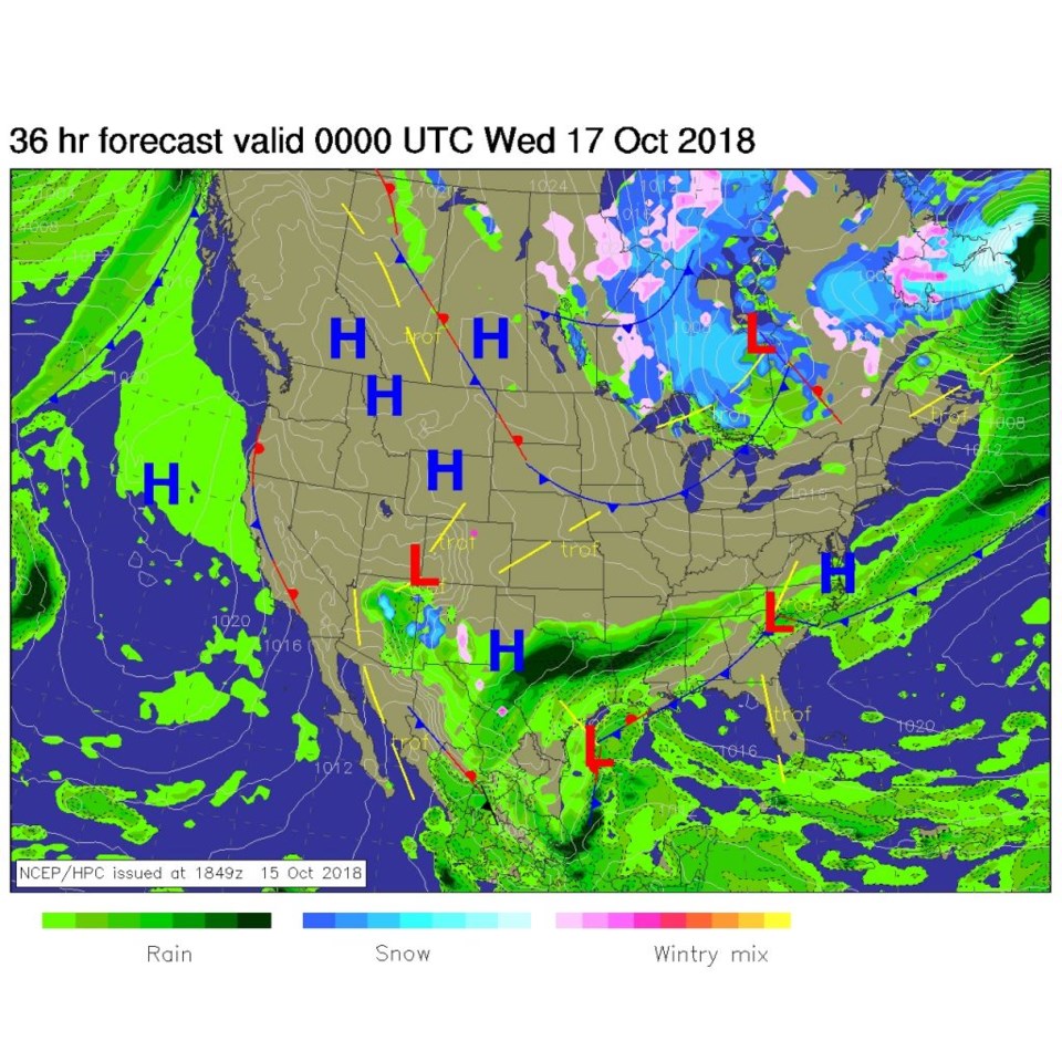
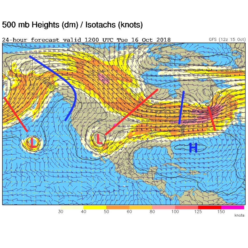
Figure 1 shows high pressure to the north and clear (mostly clear) skies over the state today. That interesting low in the southwest has inched up to near the four corners and is pumping some rain into AZ and serious water into flooded Texas. The upper air pattern (Figure 2) shows that cutoff low rolling over Arizona and that right-side uplift/storminess region over Texas and New Mexico. This is still predicted to stay to our south.

Note: I'll be on a big family vacation at the end of the month. There will be no updates to this column for the period October 26-Nov 4.

Figure 1: The forecast surface map for Wednesday p.m. From NCEP.

Figure 2: The 500mb forecast upper air analysis for Wednesday p.m.. Pink dot is Longmont. Red lines are troughs, blue lines are ridges.

The longer range forecast:

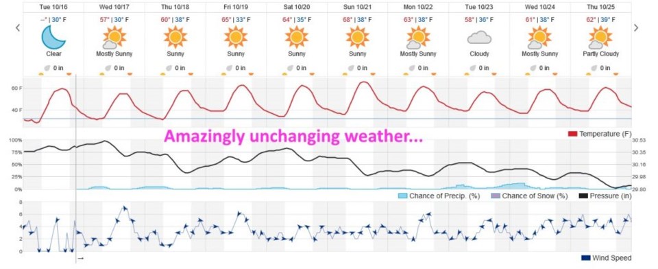
Looking off into the distance, temperatures bob up and down around 60°F (Figure 3). Our snow melts and nothing new falls, but things don't get hot either. Nighttime temperatures stay above freezing. You still have time to drain/blow-out the sprinklers if you haven't yet.

Figure 3: the next 10 days of the graphical forecast for Longmont, CO from weatherunderground.com

Current Weather

Heavy snow

Heavy snow

31°F

UV Index
0 Low
Pressure
30.33 Falling
Visibility
1 miles
Dewpoint
29 °F
Humidity
93%
Wind
ENE 1.1 mph
Gust
1.7 mph
Wind Chill
31 °F

Hourly Forecast

Today
4 AM
33°F
Snow
Today
5 AM
33°F
Snow
Today
6 AM
33°F
Snow
Today
7 AM
33°F
Cloudy
Today
8 AM
30°F
Flurries
Today
9 AM
32°F
Snow
Today
10 AM
33°F
Cloudy
Today
11 AM
34°F
Cloudy
Today
12 PM
35°F
Cloudy
Today
1 PM
37°F
Cloudy
Today
2 PM
38°F
Cloudy
Today
3 PM
40°F
Cloudy

7 Day Forecast

Rain and snow

Friday

41 °F

Chilly; rain and snow showers in the morning with little or no accumulation followed by rain and drizzle in the afternoon


Snow

Friday Night

30 °F

Periods of wet snow, accumulating 1-3 inches; roads could be slippery


Flurries

Saturday

40 °F

A bit of morning snow with little or no accumulation; otherwise, cloudy and cold; storm total snowfall 1-3 inches; roads could be slippery


Intermittent clouds

Saturday Night

32 °F

A shower in places this evening; otherwise, partly cloudy


Partly sunny

Sunday

63 °F

Partly sunny and warmer


Mostly clear

Sunday Night

40 °F

Mainly clear


Intermittent clouds

Monday

79 °F

Warmer with intervals of clouds and sun


Partly cloudy

Monday Night

40 °F

Partly cloudy


Mostly cloudy

Tuesday

66 °F

Mostly cloudy and not as warm


Intermittent clouds

Tuesday Night

40 °F

Partly cloudy


Sunrise and Sunset

Sunrise
6:15 AM
Sunset
7:44 PM

Based on AccuWeather data