Skip to content

The Next Storm/Next Snow Forecast Discussion from the Cherrywood Observatory – May 27, 2018

This content was originally published by the Longmont Observer and is licensed under a Creative Commons license.

Forecast discussion:

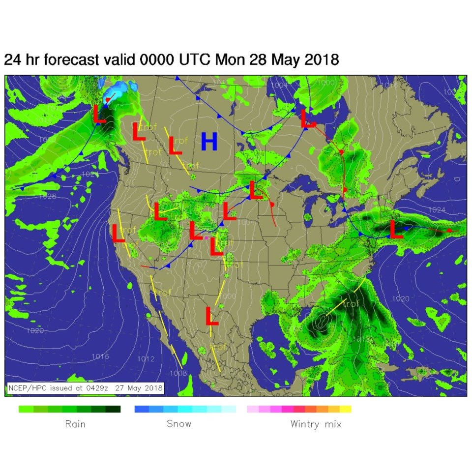
Change is returning to Colorado as a front (seen in tonight's forecast map in Figure 1) approaches. This map also predicts thunderstorms in the area this afternoon.

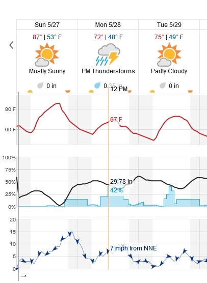
Figure 2 shows the next three days graphically for Longmont. There is a 15% chance of thunderstorms today, but an almost 50/50 chance for Monday afternoon.  The higher chances of thunderstorm activity Monday (with temperatures dramatically lowered to the lower 70'sF by the front) runs from roughly noon to 6pm Monday.

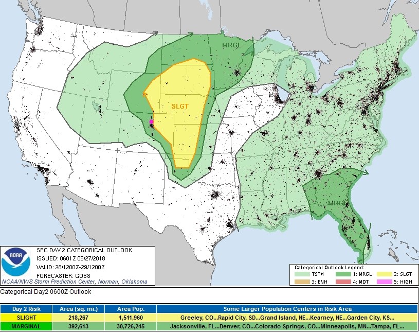
Figure 3 is the severe weather outlook for today - and we are in the marginal (1 on a scale of 1-5) today with a slight (2 on a scale of 1-5) just along I-25 and eastward (a large area).

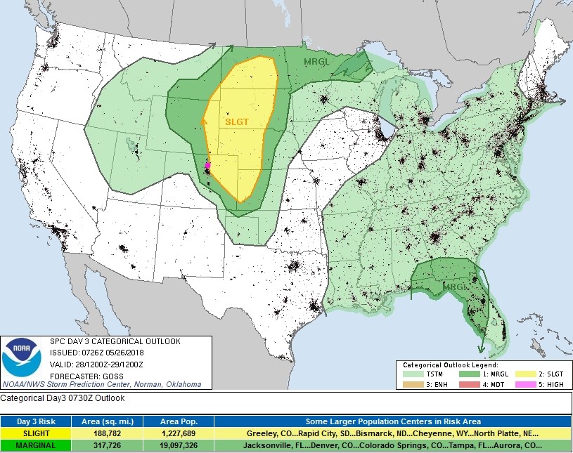
Figure 4 is Monday's (Memorial Day's) outlook, and it is very similar with the slight (2 of 5 scale) maybe just back a bit closer to us. The primary threat of severe weather both days is of hail and high winds.  There is a bit of a better chance of isolated tornadoes in the slight risk area (not too far away!).

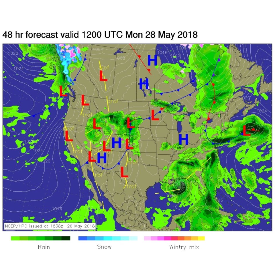
Figure 5 is the weather map for Monday morning, with more thunderstorm action behind the front.

Figure 1: The forecast surface analysis map for Saturday PM from NCEP.

Figure 2: the first 3 days of the 10 day graphical forecast for Longmont from weatherunderground.com

Figure 3: the day 2 SPC thunderstorm and severe weather forecast made Saturday (valid Sunday).

Figure 4: the day 3 SPC thunderstorm and severe weather forecast made Saturday (valid Monday).

Figure 5: The forecast surface analysis map for Monday AM from NCEP.

The longer range forecast:

We repeat last week very closely with a chance of afternoon thunderstorms Tuesday and Wednesday as the temperatures rise.  Then we break 90F again and the atmosphere dries out.  Thunderstorms, and a bit of cool down may return at the end of the week.  Nothing TOO notable!

Current Weather

Mostly cloudy

Mostly cloudy

47°F

UV Index
0 Low
Pressure
29.57 Falling
Visibility
8 miles
Dewpoint
41 °F
Humidity
79%
Wind
SSW 2.3 mph
Gust
5.6 mph
Wind Chill
47 °F

Hourly Forecast

Today
7 AM
52°F
Cloudy
Today
8 AM
55°F
Cloudy
Today
9 AM
60°F
Cloudy
Today
10 AM
62°F
Cloudy
Today
11 AM
65°F
Cloudy
Today
12 PM
68°F
Cloudy
Today
1 PM
67°F
Mostly cloudy
Today
2 PM
70°F
Mostly cloudy
Today
3 PM
68°F
Mostly cloudy
Today
4 PM
67°F
Mostly cloudy
Today
5 PM
65°F
Cloudy
Today
6 PM
58°F
Thunderstorms

7 Day Forecast

Thunderstorms

Friday

70 °F

Mostly cloudy with a couple of thundershowers this afternoon; gusty winds and small hail can accompany any downpour


Thunderstorms

Friday Night

45 °F

Cloudy; a couple of showers and a thunderstorm this evening followed by periods of rain late; gusty winds and small hail can accompany any downpour


Rain

Saturday

48 °F

Chilly with periods of rain and a thunderstorm; travel in the foothills and mountains will be slippery due to snow


Rain and snow

Saturday Night

39 °F

Cloudy with rain, mixed with a little snow late; travel in the foothills and mountains will be slippery due to snow


Mostly cloudy

Sunday

59 °F

Mostly cloudy and warmer


Partly cloudy

Sunday Night

36 °F

Partly cloudy


Partly sunny

Monday

71 °F

Partly sunny, pleasant and warmer


Partly cloudy

Monday Night

45 °F

Partly cloudy


Mostly sunny

Tuesday

73 °F

Pleasant with sunshine and patchy clouds


Partly cloudy

Tuesday Night

43 °F

Partly cloudy


Sunrise and Sunset

Sunrise
6:06 AM
Sunset
7:51 PM

Based on AccuWeather data