This content was originally published by the Longmont Observer and is licensed under a Creative Commons license.
Forecast Discussion:
UPDATE 11am:
...FLASH FLOOD WATCH IN EFFECT FROM 3 PM MDT THIS AFTERNOONTHROUGH SATURDAY EVENING...
The National Weather Service in Denver has issued a
* Flash Flood Watch for portions of central Colorado, north
central Colorado, and northeast Colorado, including the
following areas, in central Colorado, Jefferson and West
Douglas Counties Above 6000 Feet/Gilpin/Clear Creek/Northeast
Park Counties Below 9000 Feet. In north central Colorado,
Larimer County Below 6000 Feet/Northwest Weld County and
Larimer and Boulder Counties Between 6000 and 9000 Feet. In
northeast Colorado, Boulder And Jefferson Counties Below 6000
Feet/West Broomfield County, Central and East Adams and
Arapahoe Counties, Central and South Weld County, Logan
County, Morgan County, North Douglas County Below 6000
Feet/Denver/West Adams and Arapahoe Counties/East Broomfield
County, Northeast Weld County, Phillips County, Sedgwick
County, and Washington County.
* From 3 PM MDT this afternoon through Saturday evening
* A slow moving upper level storm along with plenty of available
moisture will provide the potential for flooding.
* Heavy rain is possible with this system across some areas of
northeast Colorado. There is still some uncertainty regarding
the exact locations where the heaviest rain will fall. Rainfall
totals with this system could be 3 to 5 inches by Saturday
evening in the watch area.
PRECAUTIONARY/PREPAREDNESS ACTIONS...
A Flash Flood Watch means that conditions may develop that lead
to flash flooding. Flash flooding is a very dangerous situation.
You should monitor later forecasts and be prepared to take action
should Flash Flood Warnings be issued.
End Update 11am:
UPDATE 8am:
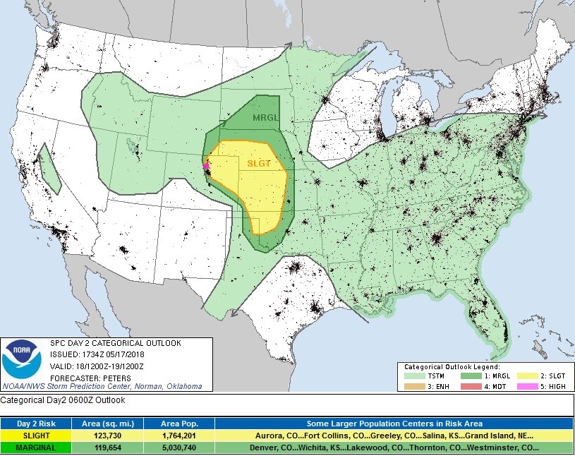
The SPC has lowered our risk of severe weather to a Marginal Risk (1 on a scale of 1-5) inducing Ft. Collins to Denver, Estes Park and Boulder. The Slight Risk (2 on a scale of 1-5) begins between Greeley and Fort Morgan and out east of DIA. Cool, moist outflow from the big thunderstorms up in Wyoming, Nebraska and NE Colorado, last night, has made it back to the Front Range and has stabilized the atmosphere here. Still, severe thunderstorms that form may produce golf ball sized hail, damaging straight line winds, and an isolated tornado.
As for rainfall, the NWS is discussing their concern of flooding with this Friday to Saturday PM event. Here is an update on what models are painting Longmont and where and what amount is at the maximum bullseye by that model:
Weatherunderground.com: 2.94 inches
The National Weather Service (NWS) 2.05 inches
The GFS has an incredible 6 inches of rain, the bullseye is just up in Greeley at 7 inches.
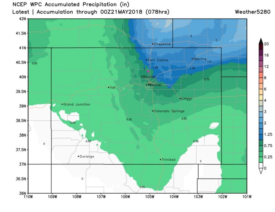
The WPC: 1.25 inches (max up on the NE Wyoming border at 2 inches)
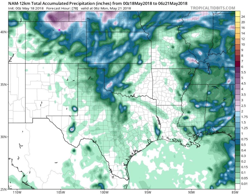
The NAM: 1.75 inches (max 4 inches out towards Sterling).
The GEPS: 1.50 inches (max 2 inches up near the Wyoming, Colorado, Nebraska border).
From the NWS:
The 00z GFS GOES bonkers with an area of 5-8 inches of rainfall from Denver north toFort Collins and extending west into the foothills for this afternoon through Saturday
afternoon. The NAM and Gem show 3-6 inches of rainfall on the backside of the
mesoscale convective vortex in the northern foothills and southeast Wyoming. The
European model (ecmwf) is lighter and only shows about 2 inches of rain.
So the GFS, this morning, was an outlier (again the NWS used the word "bonkers") - but a couple of inches is quite likely almost everywhere north of Denver with local spots getting a lot more under thunderstorms.
Concerning snow, I'll quote the NWS again:
Snow level will fall overnight and end up close to 9000 feet mean sea levelby 12z [6am MT] Saturday in the northern mountains. Will issue a Winter
Storm Watch for the Front Range mountains, north of I-70.
End 8am update.
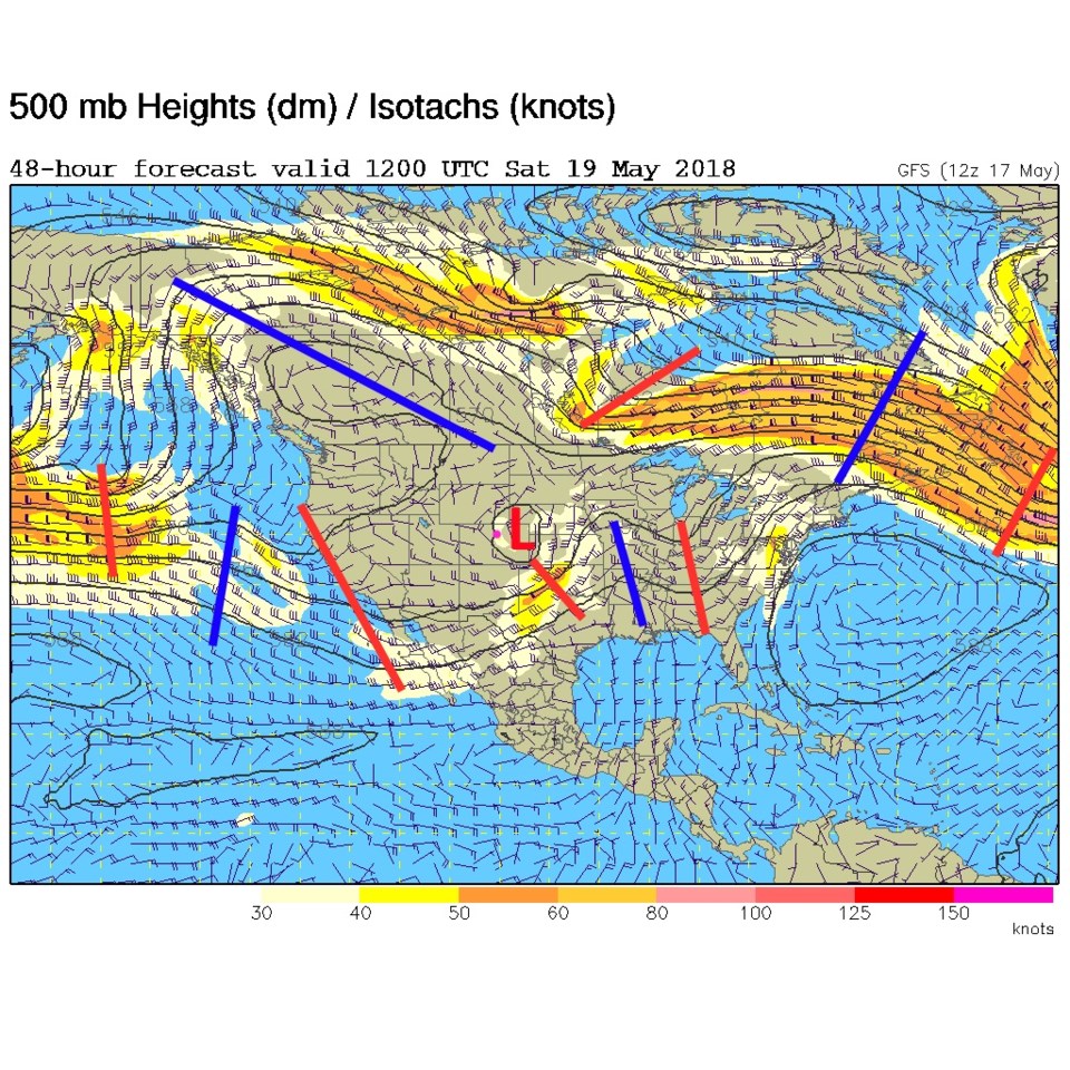
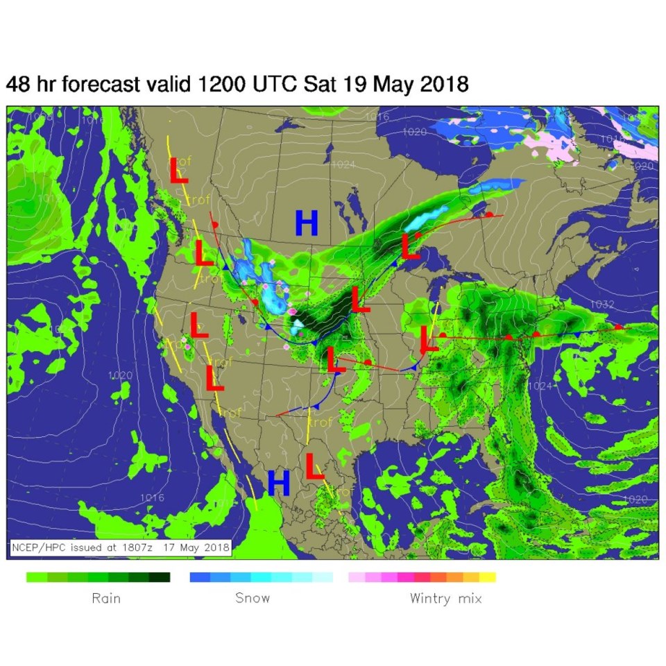
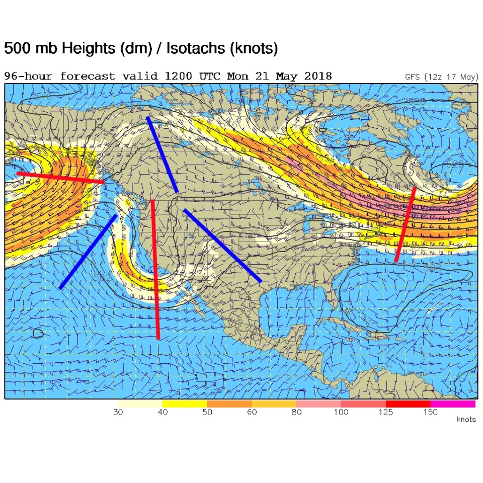
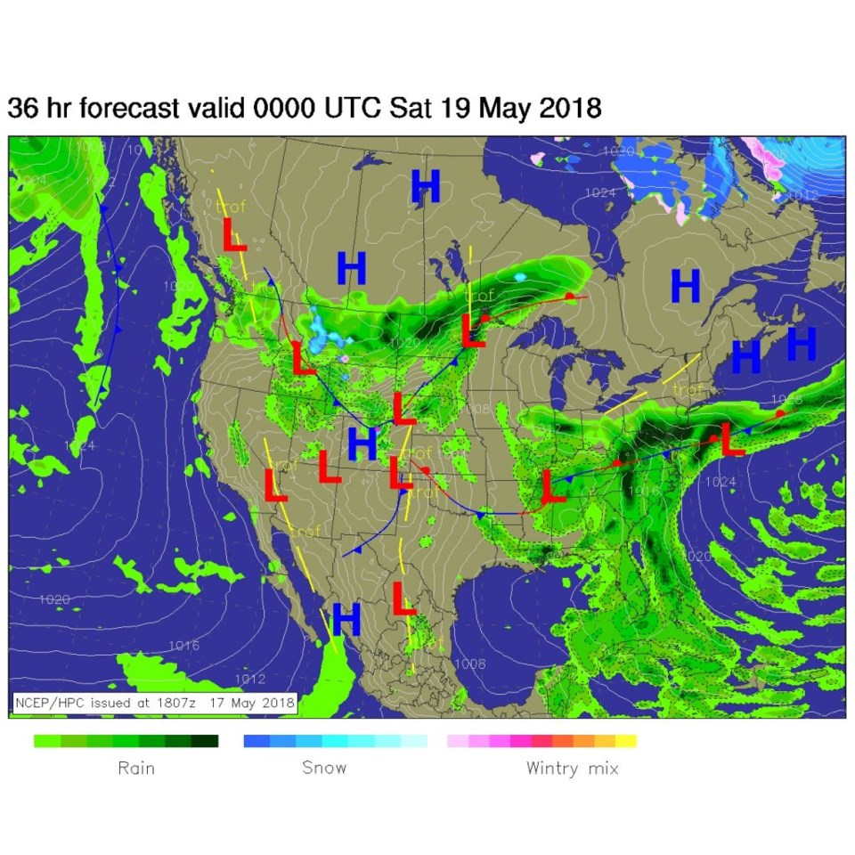
The fun begins today! Figure 1 is the 500mb upper air map today and the trough (still negatively tilted, so stronger than otherwise) is bearing down on Colorado. Figure 2 is the surface map for this evening with the front sliding down the front range. The major severe weather that will occur today will largely occur prior to that cold (more stable) surface air's arrival.
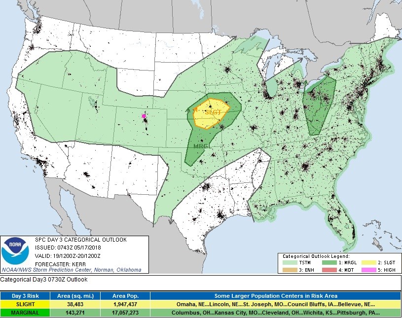
The SPC (in Figure 3) has Longmont under a Slight risk of severe weather (2 on a scale of 1-5) today. That translates to the following probability of the listed severe event occurring within 25 miles of your location:
...MAXIMUM RISK BY HAZARD...Tornado: 5% - Slight
Wind: 15% - Slight
Hail: 15% - Slight
Timing:
Rain chances begin to increase around 10am then really jump in around 2-3pm (probably when the severe risk kicks in). I'll update this post in the morning if the SPC changes things or becomes more specific about it.
After the cool front arrives (right now it looks like around 4-5pm), a strong up slope flow will begin and continue high rain chances through the the night with rain beginning to break up after 2pm Saturday (Figure 2 again). Showers may continue overnight to sunrise Sunday.
The longer range forecast:
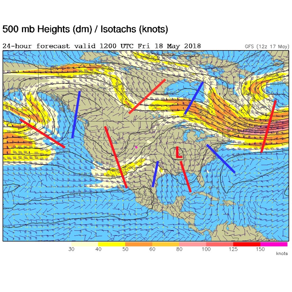
Figure 4 shows the trough over eastern Colorado with a small cutoff low embedded in the flow (red L). But there is an overall deep trough over the entire western US in the southern branch of the jet stream (note: in all the upper air maps shown today, there is a northern and southern branch of the jet stream, each with its own pattern of ridges and troughs). This cutoff low overhead lends more lift and cool air aloft for rain.
Figure 5, from the SPC, shows a general chance of thunderstorms all day, but the cool air at the surface, along with rain and low clouds all Saturday, will keep severe weather from occurring.
Figure 6 is the surface map Saturday morning. The front is down to around Colorado Springs. I don't think I've seen that dark of a shade of green painted on the weather map before (just north of us in this forecast).
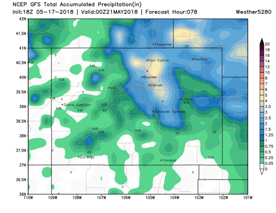
How about the models and rainfall?
Figure 7 is the GFS up through Sunday PM (it keeps raining beyond this, some, but the bulk of this system will have passed). We are given 3.5 inches of water Fri-Sun.
Figure 8 is the WPC for this same time period. It only gives us around 0.90 inches of rain.
Figure 9 is the NAM up through late Sunday PM - we are in the 2 to 2.5 inch area.
You still get to take your pick of 1, 2.5, or 3.5 inches of water.
As a bonus, Figure 10 is the upper air map for Monday AM and another trough is headed in to kick of severe weather Monday PM. This could end up being a VERY VERY wet Spring if this pattern doesn't change.
I'll update with severe weather information if needed in the morning.