Skip to content

The Next Storm/Next Snow Forecast Discussion from the Cherrywood Observatory – May 16, 2018

This content was originally published by the Longmont Observer and is licensed under a Creative Commons license.

Forecast Discussion:

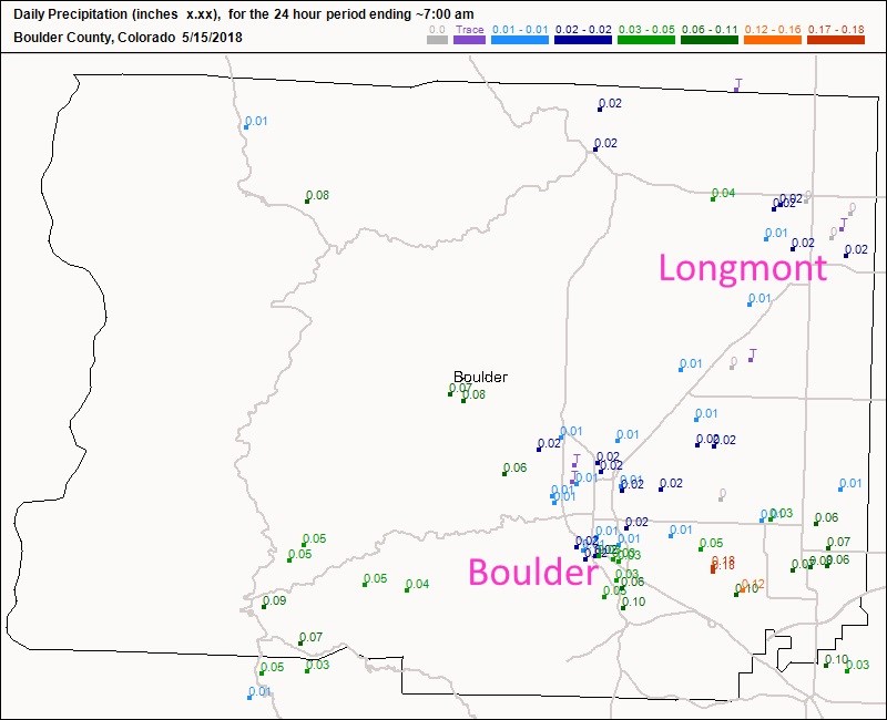
Even though we had a marginal risk (on the eastern side of Longmont, at least) - nothing happened around her for a second day.  Denver and south Denver got hit by hail and thunderstorms again.  For yesterday, though, Figure 1 shows that Longmont picked up just a few hundredths of an inch of rain on Monday.  Boulder didn't do much better except down on their south side where 1/10th of an inch fell.

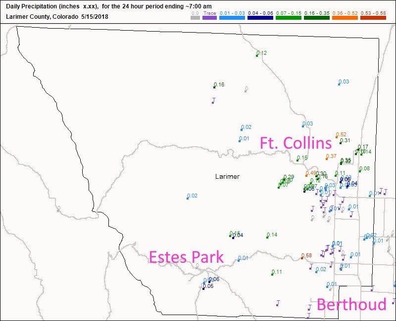
Figure 2 shows parts of Ft. Collins picked up 1/3rd to 1/2 inch of rain while other parts of town didn't see any rain. Estes Park still only got a few hundredths.  Berthoud saw a sprinkle.

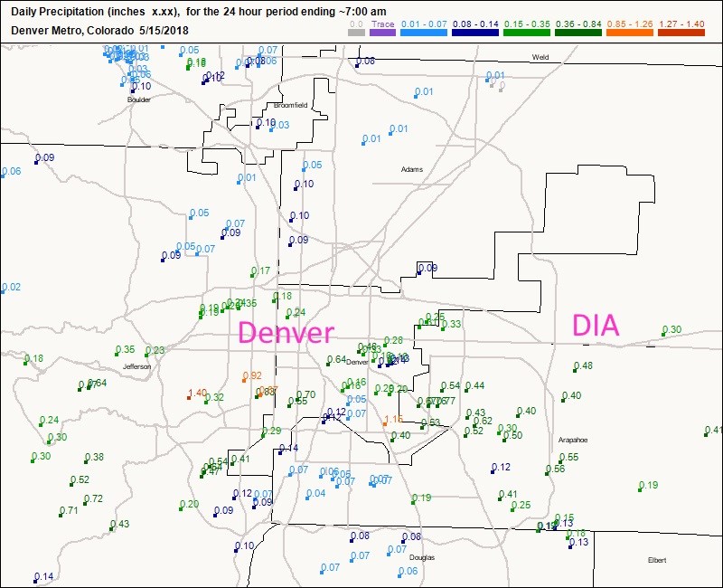
Figure 3 has Denver getting up to 1 and 4/10ths inch of rain in one spot, wide spread 1/2 inch amounts, and other places getting nearly nothing.  Oh the joys of thunderstorm rain coverage.

Today and tomorrow will see dry weather with temperatures near 80F. (There is always a chance of a lonely storm wandering off the mountains to get us.... but a small chance.)

Then things change for the weekend... see below...

Figure 1: the CoCoRaHS precipitation reports for Boulder county by 7am Tuesday (the prior 24 hours of accumulation).

Figure 2: the CoCoRaHS precipitation reports for Larimer county by 7am Tuesday (the prior 24 hours of accumulation).

Figure 3: the CoCoRaHS precipitation reports for the Denver Metro by 7am Tuesday (the prior 24 hours of accumulation).

The longer range forecast:

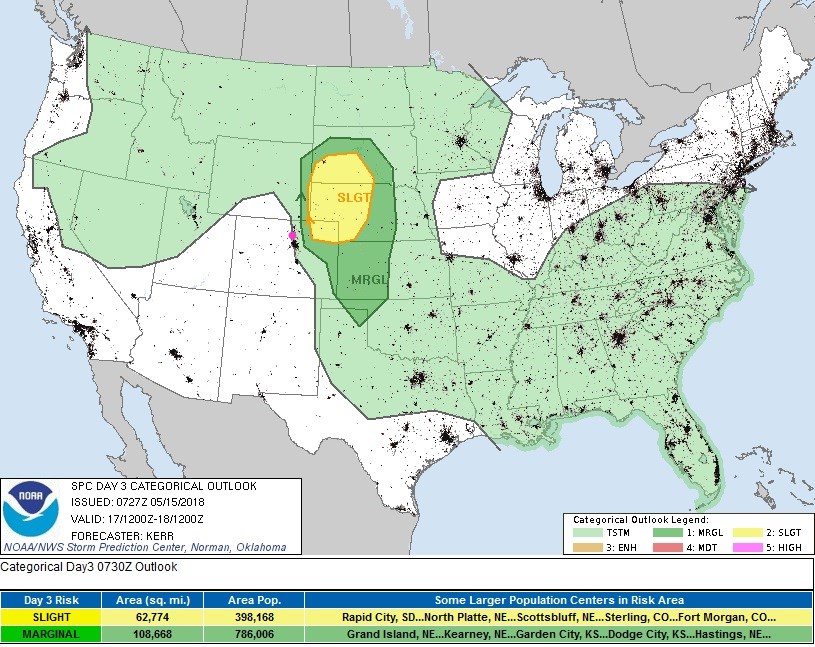
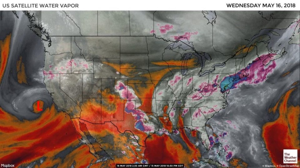
Our next system is a cutoff low that one can see in the water vapor satellite image in Figure 5 (red L off the California coast).  As that approaches, thunderstorm chances begin to return.  Figure 4 has us painted with a chance of thunderstorms on Thursday, but severe weather is just a few 10's of miles off to our east and northeast. There is guidance that severe weather chances will be much higher around Longmont on Friday.

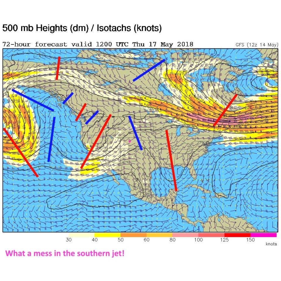
Figure 6 is a complex (messy) upper air forecast map for Thursday AM.  Our thunderstorm chances are increasing as that low (in figure 5) moves towards us (in figure 6).

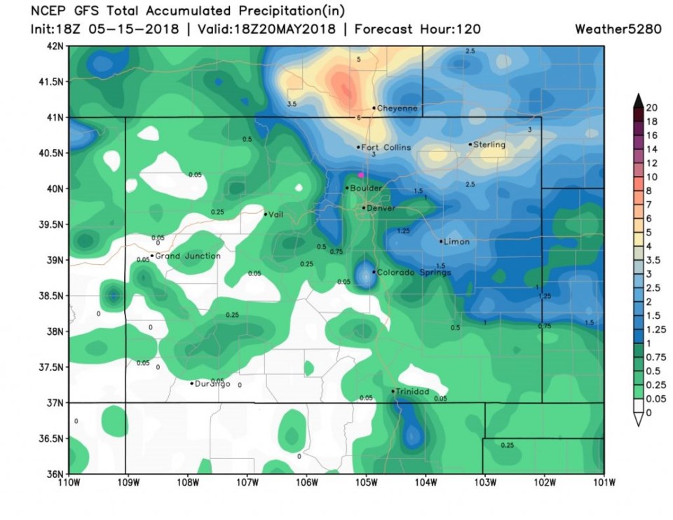
Messy patterns are harder to forecast, so we'll see a lot of variability in the forecast until the weekend gets closer. Figure 7 is the GFS precipitation total by Monday next week.  The super bullseye of rainfall that was near Longmont yesterday is now up around Ft. Collins and further up into Wyoming. We'll see that hop around a bit each day until it gets a hold on reality. Still, Figure 7 puts Longmont on the edge of the 1 inch rainfall region.

More later!

Figure 4: the day 3 SPC thunderstorm and severe weather forecast made Tuesday (valid Thursday).

Figure 5: the water vapor satellite image live Tuesday PM (reds/browns are dry air, whites and grey (and pink) are moist air.

Figure 6: The 500mb upper air analysis forecast from the GFS for Thursday AM.

Figure 7: The total precipitation estimate between Tuesday PM and Monday May 21st at noon from the GFS and weather5280.com

Current Weather

Cloudy

Cloudy

32°F

UV Index
0 Low
Pressure
30.35 Steady
Visibility
7 miles
Dewpoint
30 °F
Humidity
94%
Wind
ENE 1.1 mph
Gust
2.2 mph
Wind Chill
32 °F

Hourly Forecast

Today
2 AM
33°F
Cloudy
Today
3 AM
33°F
Cloudy
Today
4 AM
33°F
Snow
Today
5 AM
33°F
Snow
Today
6 AM
33°F
Snow
Today
7 AM
33°F
Cloudy
Today
8 AM
30°F
Flurries
Today
9 AM
32°F
Snow
Today
10 AM
33°F
Cloudy
Today
11 AM
34°F
Cloudy
Today
12 PM
35°F
Cloudy
Today
1 PM
37°F
Cloudy

7 Day Forecast

Rain and snow

Friday

41 °F

Chilly; rain and snow showers in the morning with little or no accumulation followed by rain and drizzle in the afternoon


Snow

Friday Night

30 °F

Periods of wet snow, accumulating 1-3 inches; roads could be slippery


Flurries

Saturday

40 °F

A bit of morning snow with little or no accumulation; otherwise, cloudy and cold; storm total snowfall 1-3 inches


Intermittent clouds

Saturday Night

32 °F

A shower in places this evening; otherwise, partly cloudy


Partly sunny

Sunday

63 °F

Partly sunny and warmer


Mostly clear

Sunday Night

40 °F

Mainly clear


Intermittent clouds

Monday

79 °F

Warmer with intervals of clouds and sun


Partly cloudy

Monday Night

40 °F

Partly cloudy


Mostly cloudy

Tuesday

66 °F

Mostly cloudy and not as warm


Intermittent clouds

Tuesday Night

40 °F

Partly cloudy


Sunrise and Sunset

Sunrise
6:15 AM
Sunset
7:44 PM

Based on AccuWeather data