Skip to content

The Next Storm/Next Snow Forecast Discussion from the Cherrywood Observatory – March 13 , 2018

This content was originally published by the Longmont Observer and is licensed under a Creative Commons license.

Forecast Discussion:

A weak cool front traveled in before sunset and put down sprinkles around the Wyoming border and Ft. Collins Monday PM (Figure 1). Things stabilized after dark and a few drops hit Longmont.  Now we return you to your regularly scheduled warm-up.

Figure 1: MyRadarPro life radar image Monday afternoon (iOS app).

The longer range forecast:

We do have an interesting 'bonus' storm that may give Longmont some measurable rain come Thursday PM and Friday AM.  We'll cover this, now, instead of the weekend pattern change and unsettled turn to the weather expected then.

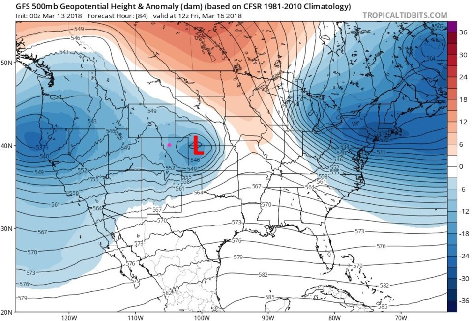
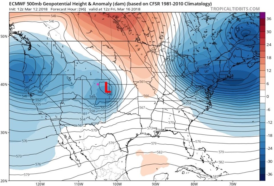
The next four images will be a quick study of the difference between the GFS (Global Forecast System - from our National Weather Service) model and the ECMWF (European Centre for Medium-Range Weather Forecasts) model.

Figure 2 is Friday morning at 500mb heights with a low center in NW Kansas. Figure 3 is the European model for the same time with the low closer to Longmont.  I always cover the 500mb level for simplicity and consistency, but we have maps at lower levels (like the 850mb and 700mb) and higher (like the 300mb) heights.  Storms are not always vertically stacked in the atmosphere, which can impact their speed and severity.

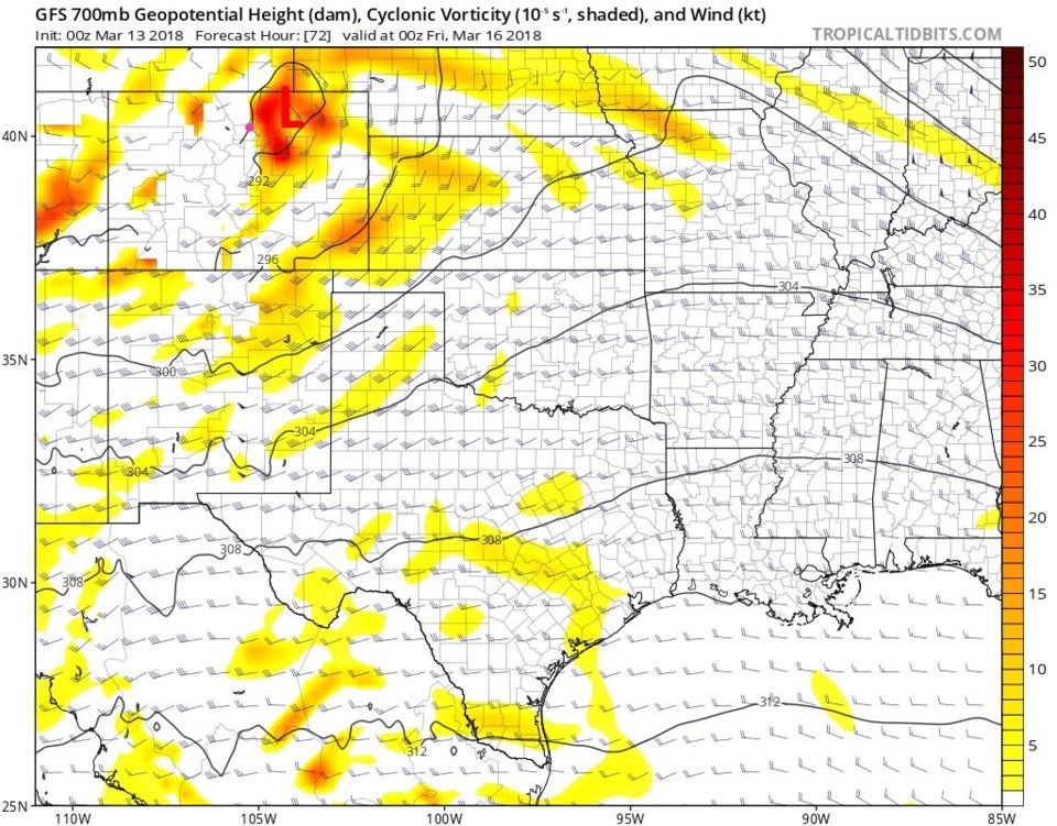
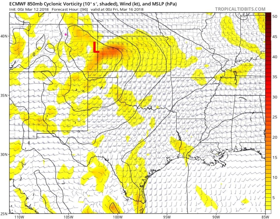
Figure 4 is the 700mb map (at and below ground level for the Rockies) with the Low just east of town late Thursday PM on the GFS. Figure 5 for the same time at 850mb (even lower - so extrapolated for levels below ground level) from the European model. The Low center is off on the Kansas boundary in the lower atmosphere.

The European is better positioned for mountain snows (and rain for us) - but both now give us some weather by Friday AM.

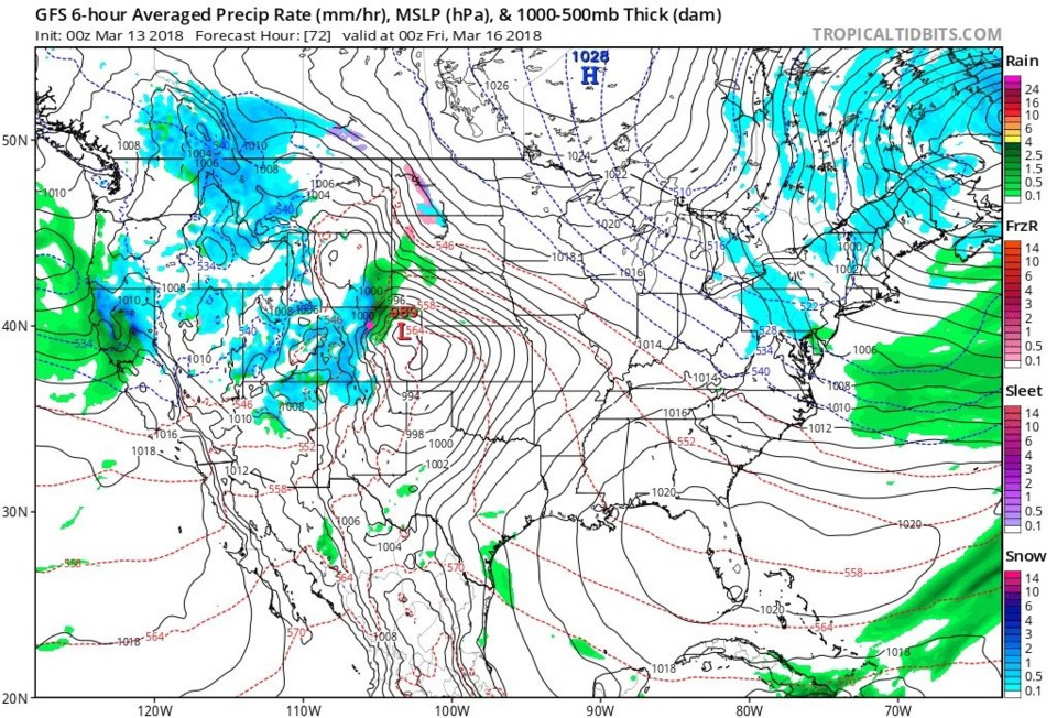
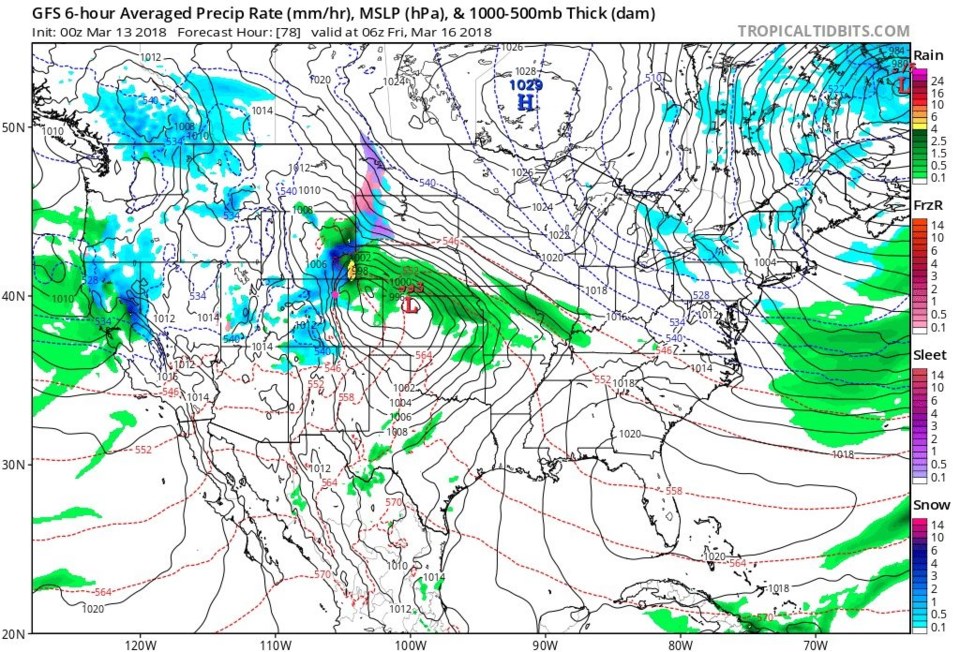
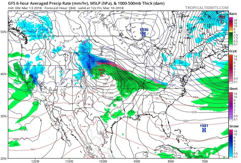
Figures 6, 7 and 8 are the Thursday PM, Friday early AM, and Friday AM surface maps showing the surface low, from the GFS, out east of us and stalling briefly in NW Kansas.  Some nice wrap-around precipitation hits Longmont (even though there is a strip of down slope dry air that forms mid-storm, grrrr).

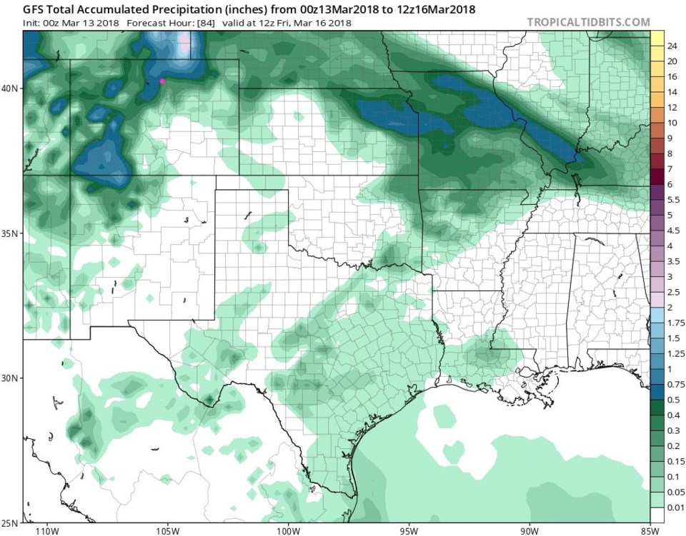
Figure 9 shows total water amounts by Friday morning around 1/2 inch for Longmont.  This is a nice gift out of nowhere ... as long as it doesn't vanish back into model-nowhwere.

Figure 2: The GFS 500mb upper air height and anomaly map for Friday morning from tropicaltidbits.com

Figure 3: The ECMWF 500mb upper air height and anomaly map for Friday morning from tropicaltidbits.com

Figure 4: The GFS 700mb upper air height and vorticity map for Friday morning from tropicaltidbits.com

Figure 5: The ECMWF 850mb upper air height and vorticity map for Friday morning from tropicaltidbits.com

Figure 6: The U.S. surface pressure and precipitation forecast map from the GFS and for Thursday PM from tropicaltidbits.com

Figure 6: The U.S. surface pressure and precipitation forecast map for early Friday AM from the GFS andtropicaltidbits.com

Figure 8: The U.S. surface pressure and precipitation forecast map for Friday AM from the GFS and tropicaltidbits.com

Figure 9: The total accumulated precipitation forecast map between Monday PM and Friday AM from the GFS and tropicaltidbits.com

Current Weather

Mostly cloudy

Mostly cloudy

68°F

UV Index
9 Very High
Pressure
29.6 Steady
Visibility
8 miles
Dewpoint
29 °F
Humidity
24%
Wind
WNW 6.1 mph
Gust
12.9 mph
Wind Chill
68 °F

Hourly Forecast

Today
1 PM
68°F
Showers
Today
2 PM
69°F
Intermittent clouds
Today
3 PM
70°F
Intermittent clouds
Today
4 PM
68°F
Intermittent clouds
Today
5 PM
66°F
Mostly cloudy
Today
6 PM
61°F
Thunderstorms
Today
7 PM
58°F
Thunderstorms
Today
8 PM
56°F
Cloudy
Today
9 PM
53°F
Cloudy
Today
10 PM
51°F
Thunderstorms
Today
11 PM
49°F
Thunderstorms
Tomorrow
12 AM
48°F
Cloudy

7 Day Forecast

Mostly cloudy w/ t-storms

Friday

70 °F

Variable cloudiness; a morning shower in spots followed by a couple of thundershowers this afternoon; gusty winds and small hail can accompany any downpour


Thunderstorms

Friday Night

44 °F

Cloudy; a couple of showers and a thunderstorm this evening followed by periods of rain late; gusty winds and small hail can accompany any downpour


Rain

Saturday

47 °F

Chilly with periods of rain and a thunderstorm; travel in the foothills and mountains will be slippery due to snow


Rain and snow

Saturday Night

36 °F

Cloudy with rain, mixed with a little snow late; travel in the foothills and mountains will be slippery due to snow


Mostly cloudy

Sunday

61 °F

Mostly cloudy and warmer


Intermittent clouds

Sunday Night

36 °F

A thunderstorm in spots in the evening; otherwise, partly cloudy


Partly sunny

Monday

71 °F

Partly sunny, pleasant and warmer


Partly cloudy

Monday Night

45 °F

Partly cloudy


Mostly sunny

Tuesday

73 °F

Pleasant with sunshine and patchy clouds


Partly cloudy

Tuesday Night

43 °F

Partly cloudy


Sunrise and Sunset

Sunrise
6:06 AM
Sunset
7:51 PM

Based on AccuWeather data