Skip to content

The Next Storm/Next Snow Forecast Discussion from the Cherrywood Observatory – June 16, 2018

This content was originally published by the Longmont Observer and is licensed under a Creative Commons license.

Forecast Discussion:

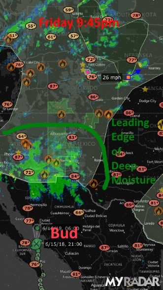
The early moisture interacted with afternoon heating to give Longmont a loud thunderstorm Friday afternoon.  We didn't receive much rain, but it poured for a few minutes. By evening, the center of Bud was just into Mexico (Figure 1). The deepest moisture is still down in New Mexico Friday evening.

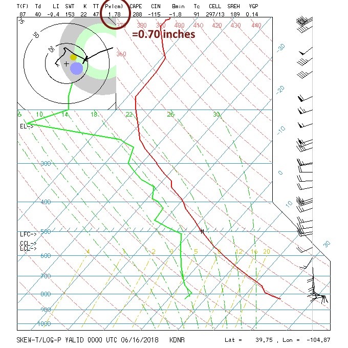
We were going to watch the precipitatable water values on the soundings.

It was 1.19cm Thursday AM (which is 0.47 inches of water). The Thursday PM precipitatable water value had already risen to 1.69cm / 0.67 inches. From Figure 2, it is at 1.78cm (0.70 inches). Models are showing 1.25 to 1.50 inches of precipitatable water by Sunday over the region. This is far above normal for June - it is similar to what one sees in the late Summer, sometimes.

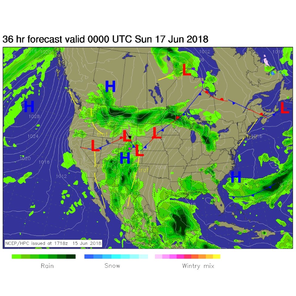
By this afternoon, the moisture will be arriving.  You can see the front that will push down later in the day (Figure 3).  This front will matter more on Sunday as it advances again. Rain is definitely hitting a LOT of the fire regions.  Figure 1 shows the flash flood watch that is already in effect in the SW corner of our state. Burn scars will flood easily and a lot of debris can be washed into waterways quickly after the fires.

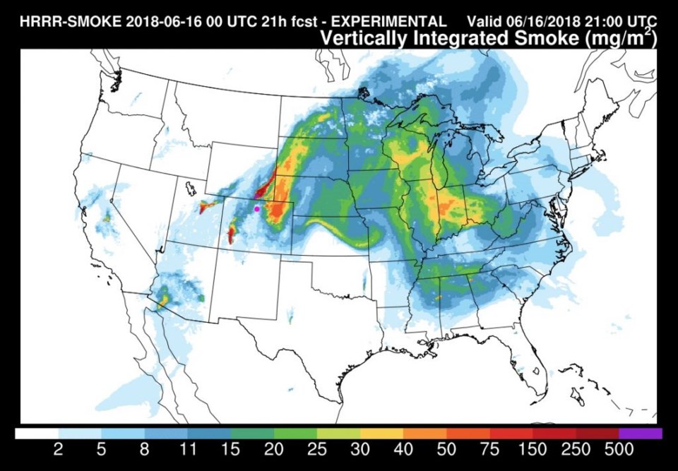
As winds increase, the smoke should blow off to the northeast a bit quicker (Figure 4). Rain will help clear the air as the weekend wears on (and, hopefully, the lower temperatures, higher humidities, and rain, will diminish fire activity).

Figure 1: MyRadar iOS app image of live radar from Friday PM. Bud's circulation center is shown. Longmont is the pink dot.

Figure 2: The sounding from Friday PM with precipitatable water highlighted for future comparison.

Figure 3: The forecast surface map for this afternoon. From NCEP.

Figure 4: The HRRR model forecast for smoke at all levels for Saturday afternoon. From NOAA.gov

The longer range forecast:

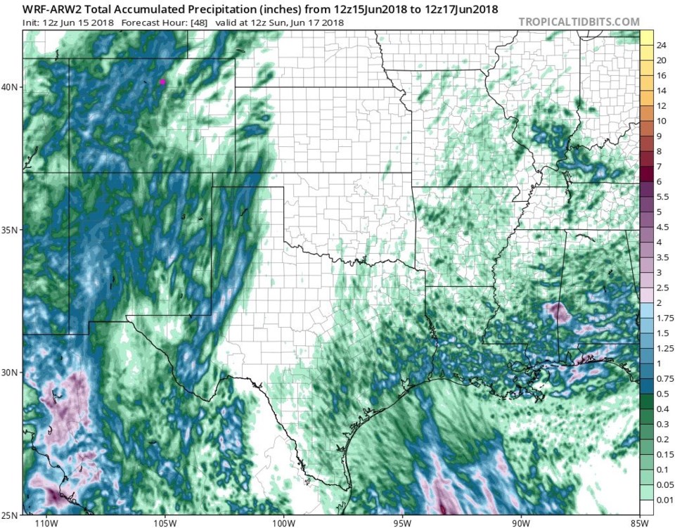
The WRF has the next 48 hours of precipitation for us.  Longmont is in the 0.5 inch to 1 inch area by Sunday morning (Figure 5).

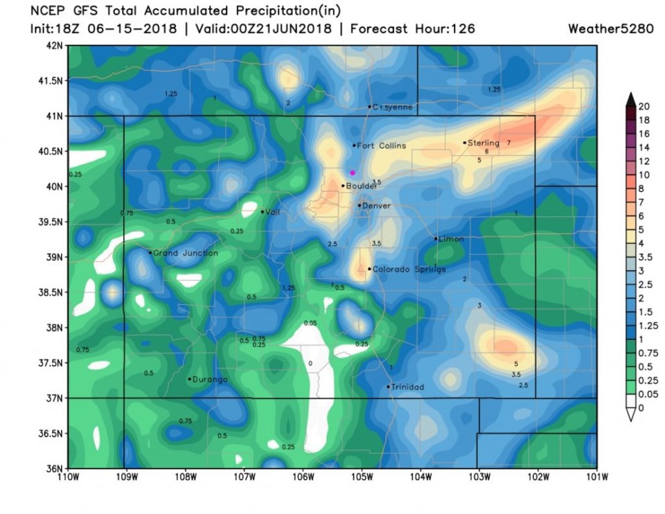
Looking out to Wednesday PM, the total precipitation for Longmont predicted by the GFS is around 1.5-2.0 inches (seems extreme, but it has been consistent). Note the 5 inch totals above Boulder. Yikes - if true. (Figure 6).

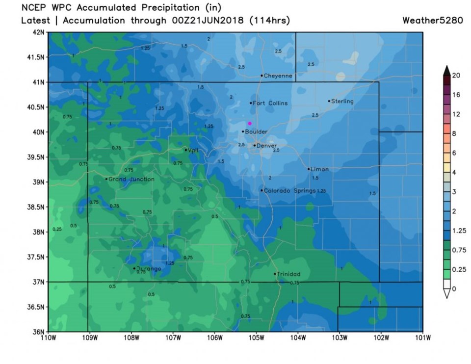
The WPC model, for this time window, gives us almost 2.5 inches of rain. Rainfall above Boulder approaches 3 inches between now and Wednesday night (Figure 7).

More tomorrow. Hopefully I'll be typing in the rain.

And happy Father's Day (early) for all the Dads out there. (We're going to a Dad-themed movie ourselves.)

Figure 5: The WRF total precipitation estimate between Friday PM and Sunday AM (48 hours) from tropicaltidbits.com

Figure 6: total precipitation from the GFS between Friday PM and late Wednesday PM. and weather5280.com. Longmont is the pink dot.

Figure 7: total precipitation from the WPC model between Friday PM and late Wednesday PM. and weather5280.com. Longmont is the pink dot.

Current Weather

Snow

Snow

34°F

UV Index
0 Low
Pressure
30.22 Falling
Visibility
2 miles
Dewpoint
32 °F
Humidity
92%
Wind
ENE 1.1 mph
Gust
2.8 mph
Wind Chill
34 °F

Hourly Forecast

Today
3 AM
34°F
Cloudy
Today
4 AM
34°F
Mostly cloudy
Today
5 AM
34°F
Mostly cloudy
Today
6 AM
34°F
Cloudy
Today
7 AM
35°F
Cloudy
Today
8 AM
34°F
Intermittent clouds
Today
9 AM
35°F
Intermittent clouds
Today
10 AM
36°F
Intermittent clouds
Today
11 AM
38°F
Intermittent clouds
Today
12 PM
40°F
Intermittent clouds
Today
1 PM
41°F
Intermittent clouds
Today
2 PM
42°F
Cloudy

7 Day Forecast

Rain and snow

Thursday

37 °F

Cloudy and much colder; snow showers in the morning, accumulating a coating to an inch followed by brief showers in the afternoon


Showers

Thursday Night

34 °F

Mostly cloudy with a brief shower or two late


Mostly cloudy w/ showers

Friday

43 °F

Chilly with some sun, then turning cloudy; a little rain this afternoon


Rain and snow

Friday Night

32 °F

Periods of snow; rain mixed in early, accumulating an inch or two


Flurries

Saturday

40 °F

A bit of morning snow with little or no accumulation; otherwise, cloudy and chilly; storm total snowfall an inch or two


Intermittent clouds

Saturday Night

31 °F

Partly cloudy


Partly sunny

Sunday

64 °F

Partly sunny, pleasant and warmer


Partly cloudy

Sunday Night

41 °F

Partly cloudy


Intermittent clouds

Monday

79 °F

Warmer with a blend of sun and clouds


Partly cloudy

Monday Night

36 °F

Partly cloudy


Sunrise and Sunset

Sunrise
6:17 AM
Sunset
7:43 PM

Based on AccuWeather data