Skip to content

The Next Storm/Next Snow Forecast Discussion from the Cherrywood Observatory – July 11th and 12th, 2018

This content was originally published by the Longmont Observer and is licensed under a Creative Commons license.

Forecast discussion:

Note: I'm nearing the end of my two week family camping trip.  My available bandwidth is very low so I'm keeping posts shorter than normal and less graphically intensive.

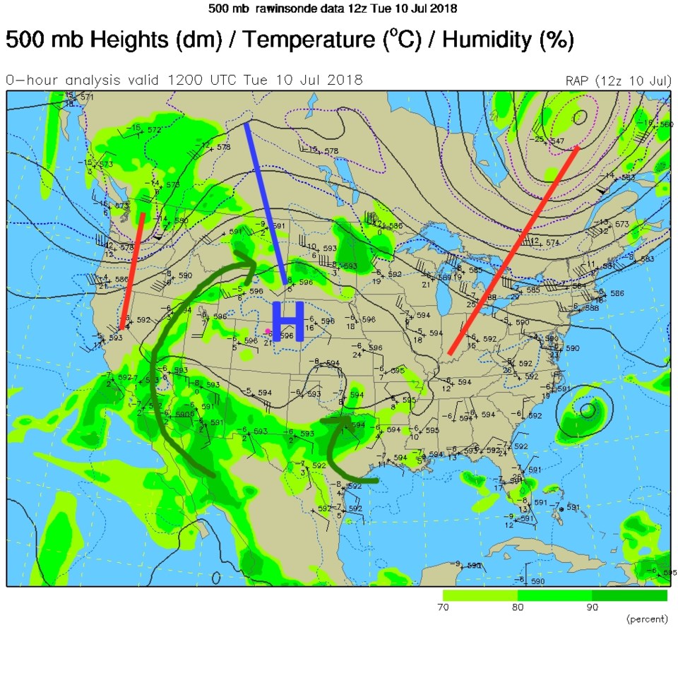
We are clearly in the where's-the-monsoon-moisture? time of year.  The giant upper air ridge and high center (Figure 1) are parked almost on top of Longmont Tuesday.  It won't move far by Wednesday, explaining the 100°F + temperatures. Remember, we average one 100°F + day every other year... so we've really hit the heat hard this year so far.  I've indicated the tropical moisture flow as dark green arrows.  The circulation around the high is pushing it all to the south and up into the west and over us to the north.

This high is also stirring the smoke from various Western U.S. fires making the skies mildly milky.  This probably won't clear out in the near future.

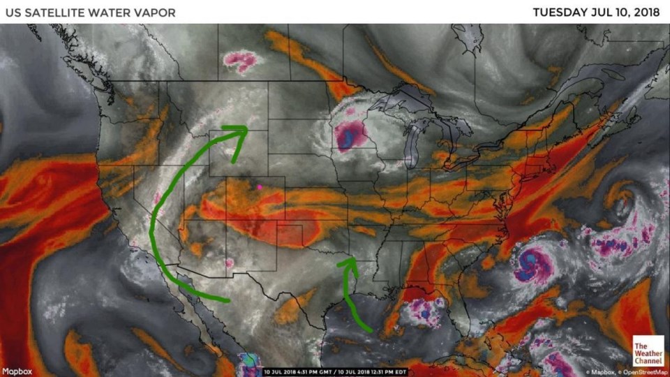
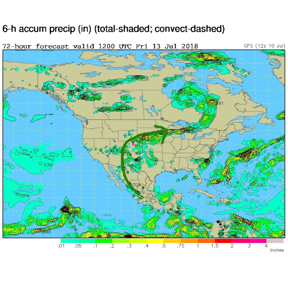
You can see the above mentioned moisture as the grey and white colors in Figure 2 - the water vapor satellite image. The change that is coming over these two days comes from the high migrating eastward and the moisture plume bending eastward with it to give Colorado cooler temperatures and chances of thunderstorm rainfall.  Thursday and Friday will see a chance of storms statewide, but no severe weather is predicted at this time.

Figure 1: The 500mb upper air analysis for Tuesday PM. Pink dot is Longmont. Red lines are troughs, blue lines are ridges.

Figure 2: the water vapor satellite image from Tuesday PM. Reds/Oranges are dry air, greys/whites are moist air regions.

Figure 3: The forecast precipitation map from the GFS and NCEP for Friday morning.

The longer range forecast:

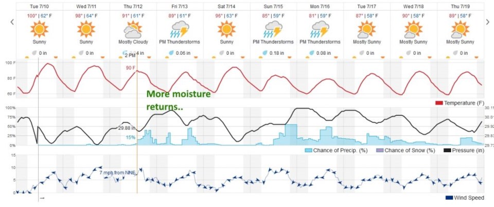
After cracking 100°F early week, we cool to around 90°F (just a bit above average) and thunderstorm chances return.  Saturday looks dry and hot again (as the plume moves east of us briefly) then the moisture rocks back to cover Colorado early next week.

Figure 4: the next 10 days of the graphical forecast for Longmont, CO from weatherunderground.com

Current Weather

Rain

Rain

48°F

UV Index
0 Low
Pressure
29.72 Rising
Visibility
7 miles
Dewpoint
44 °F
Humidity
84%
Wind
NNE 4.2 mph
Gust
8.3 mph
Wind Chill
47 °F

Hourly Forecast

Today
8 PM
56°F
Thunderstorms
Today
9 PM
53°F
Thunderstorms
Today
10 PM
50°F
Thunderstorms
Today
11 PM
48°F
Thunderstorms
Tomorrow
12 AM
46°F
Cloudy
Tomorrow
1 AM
46°F
Cloudy
Tomorrow
2 AM
45°F
Cloudy
Tomorrow
3 AM
44°F
Rain
Tomorrow
4 AM
44°F
Cloudy
Tomorrow
5 AM
44°F
Rain
Tomorrow
6 AM
44°F
Rain
Tomorrow
7 AM
44°F
Rain

7 Day Forecast

Mostly cloudy w/ t-storms

Friday

69 °F

Variable cloudiness with a couple of thundershowers this afternoon; gusty winds and small hail can accompany any downpour


Thunderstorms

Friday Night

41 °F

Cloudy; a couple of showers and a thunderstorm this evening followed by periods of rain late; gusty winds and small hail can accompany any downpour


Rain

Saturday

44 °F

Chilly with periods of rain and a thunderstorm; travel in the foothills and mountains will be slippery due to snow


Rain and snow

Saturday Night

36 °F

Cloudy with rain, mixed with a little snow late; travel in the foothills and mountains will be slippery due to snow


Mostly cloudy

Sunday

61 °F

Mostly cloudy and warmer


Intermittent clouds

Sunday Night

36 °F

A thunderstorm in spots in the evening; otherwise, partly cloudy


Partly sunny

Monday

71 °F

Partly sunny, pleasant and warmer


Partly cloudy

Monday Night

45 °F

Partly cloudy


Mostly sunny

Tuesday

73 °F

Pleasant with sunshine and patchy clouds


Partly cloudy

Tuesday Night

40 °F

Partly cloudy


Sunrise and Sunset

Sunrise
6:06 AM
Sunset
7:51 PM

Based on AccuWeather data