Skip to content

The Next Storm/Next Snow Forecast Discussion from the Cherrywood Observatory – August 8th, 2018

This content was originally published by the Longmont Observer and is licensed under a Creative Commons license.

Forecast Discussion:

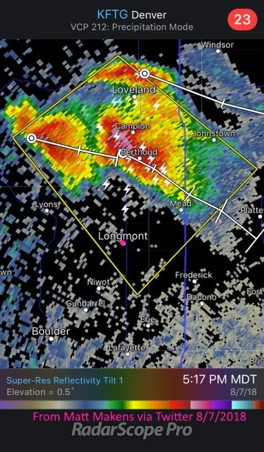
The big storms formed, were far apart (on Tuesday), and dumped serious hail on a few locations. Longmont dodged a big one around 5pm Tuesday (Figure 1).

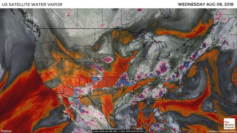
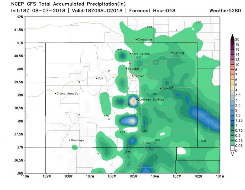
The atmosphere continues to dry out at most levels (low level moisture kept Tuesday storms alive).  The red and black colors are atmospheric columns are low on moisture content in Figure 2.  The GFS is forecasting little rain over the next 48 hours (Figure 3).  Both this model and the one used Tuesday morning on Channel 7 news had storms up in Nebraska send a gust front back to the Front Range today that initiated a big storm around Fort Collins.  That will be interesting to see if it occurs.

Figure 1: Radar image from iOS app RadarScope Pro posted on Twitter by Matt Makens

Figure 2: the water vapor satellite image from Tuesday night. Reds/Oranges are dry air, greys/whites are moist air regions.

Figure 3: The total accumulated precipitation between Tuesday PM and Thursday late PM from the GFS and weather5280.com

The longer range forecast:

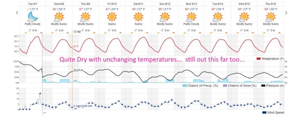
The 10 day forecast has a chance of a storm Wednesday (our storm from above?) then very little but a few afternoon storms in afternoon by the weekend and beyond. Temperatures change very little and hover in the upper 80's F throughout the forecast period (Figure 4).

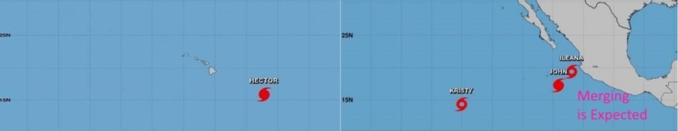
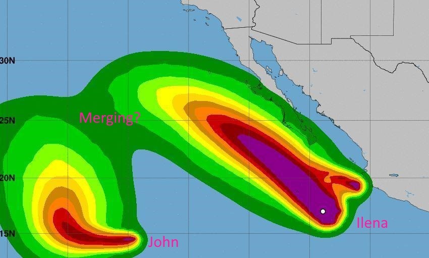
As an interesting note, we have four tropical systems between Mexico and Hawaii (Figure 5). As Joe Bastardi from WeatherBell says, you get a "Ridge over Troubled Water."  There has been a big ridge over the southwest for a long time, so this makes sense. What is even more interesting is that the eastern two-most storms (Llena and John) might merge in a few days.  I've seen tropical system dance around one another, but I've not seen two merge (Figure 6).

Figure 4: the next 10 days of the graphical forecast for Longmont, CO from weatherunderground.com

Figure 5: The hurricane lineup Tuesday in the western Pacific. From the National Hurricane Center.

Figure 6: Hurricane John impacted Tropical Storm Ileana on Tuesday, bringing rough surf conditions and heavy rain to the coast of Baja California. Forecast winds speeds. National Hurricane Center.

Current Weather

Cloudy

Cloudy

67°F

UV Index
2 Low
Pressure
29.6 Steady
Visibility
8 miles
Dewpoint
30 °F
Humidity
25%
Wind
NW 5.6 mph
Gust
10.3 mph
Wind Chill
67 °F

Hourly Forecast

Today
4 PM
68°F
Intermittent clouds
Today
5 PM
66°F
Mostly cloudy
Today
6 PM
61°F
Thunderstorms
Today
7 PM
58°F
Thunderstorms
Today
8 PM
56°F
Cloudy
Today
9 PM
53°F
Cloudy
Today
10 PM
51°F
Thunderstorms
Today
11 PM
49°F
Thunderstorms
Tomorrow
12 AM
48°F
Cloudy
Tomorrow
1 AM
48°F
Cloudy
Tomorrow
2 AM
47°F
Cloudy
Tomorrow
3 AM
46°F
Rain

7 Day Forecast

Mostly cloudy w/ t-storms

Friday

70 °F

Variable cloudiness with a couple of thundershowers this afternoon; gusty winds and small hail can accompany any downpour


Thunderstorms

Friday Night

44 °F

Cloudy; a couple of showers and a thunderstorm this evening followed by periods of rain late; gusty winds and small hail can accompany any downpour


Rain

Saturday

47 °F

Chilly with periods of rain and a thunderstorm; travel in the foothills and mountains will be slippery due to snow


Rain and snow

Saturday Night

36 °F

Cloudy with rain, mixed with a little snow late; travel in the foothills and mountains will be slippery due to snow


Mostly cloudy

Sunday

61 °F

Mostly cloudy and warmer


Intermittent clouds

Sunday Night

36 °F

A thunderstorm in spots in the evening; otherwise, partly cloudy


Partly sunny

Monday

71 °F

Partly sunny, pleasant and warmer


Partly cloudy

Monday Night

45 °F

Partly cloudy


Mostly sunny

Tuesday

73 °F

Pleasant with sunshine and patchy clouds


Partly cloudy

Tuesday Night

43 °F

Partly cloudy


Sunrise and Sunset

Sunrise
6:06 AM
Sunset
7:51 PM

Based on AccuWeather data