Skip to content

The Next Storm/Next Snow Forecast Discussion from the Cherrywood Observatory – August 25th, 2018

This content was originally published by the Longmont Observer and is licensed under a Creative Commons license.

Forecast Discussion:

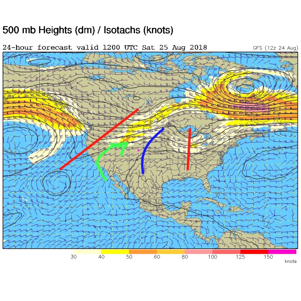
The ridge is sitting overhead and a lot of smoke has returned to the Front Range, but there is a bit of a change coming for the weekend. The ridge is being deformed to the east a bit as a trough nudges in from the west (Figure 1). There won't be much of a cool down, but a bit of monsoonal moisture and cleaner air is on the way (green arrows).

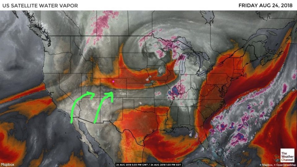
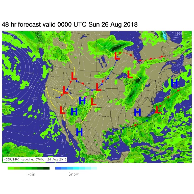
Figure 2 shows the dry air over northern Colorado on Friday (reds/oranges) but the return flow of moisture from the southwest (green arrows) isn't far away. The surface map for Saturday afternoon (Figure 3) has some showers and storms from Arizona up into the western and southern mountains of Colorado (and on the SE Plains).

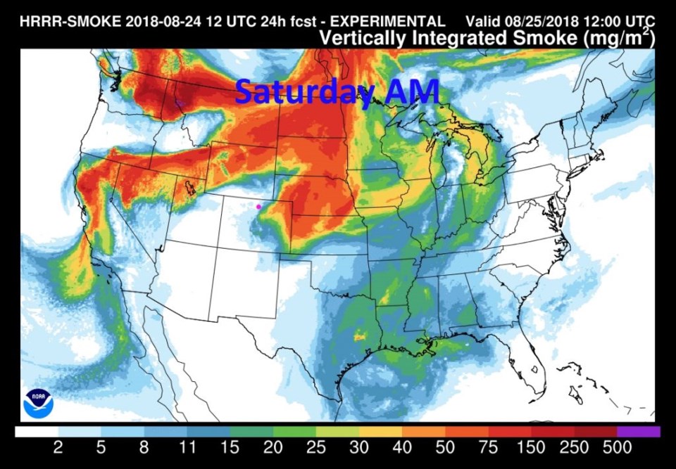
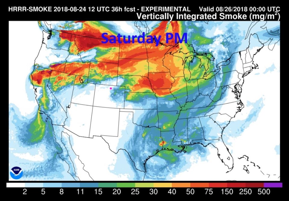
With the flow ahead of the trough, cleaner air is approaching (Figure 4). Downwind of the Rockies, it will take longer to clear since the mountains disrupt the flow. Figure 5, for tonight, has us breathing easier.

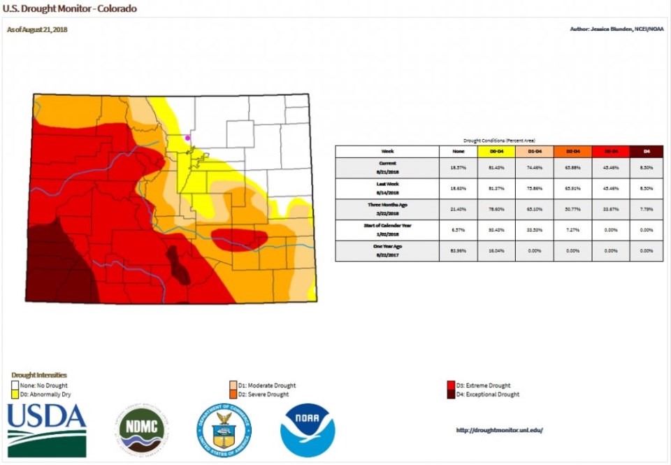
Just to check on the status of the Colorado drought quickly, Figure 6 still paints Longmont in the 'no drought' zone. There has been a bit of relief in the southwestern half of the state, but severe drought conditions still persist out there.

Figure 1: The 500mb forecast upper air analysis for Thursday PM. Pink dot is Longmont. Red lines are troughs, blue lines are ridges.

Figure 2: the water vapor satellite image from Friday noon. Reds/Oranges are dry air, greys/whites are moist air regions.

Figure 3: The forecast surface map for Saturday PM. From NCEP.

Figure 4: The HRRR (high resolution rapid refresh) model forecast of smoke at all levels for Saturday AM.

Figure 5: The HRRR (high resolution rapid refresh) model forecast of smoke at all levels for Saturday PM.

Figure 6: the Colorado page of the USGS and NOAA drought monitor index created Aug 21.

The longer range forecast:

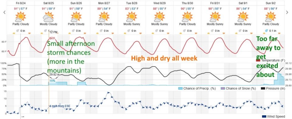
The monsoon moisture (meager for Longmont) will linger through the weekend (Figure 7) with a very small chance of afternoon storms making it off the mountains. The week looks really dry with a chance of a change next weekend (but that is far off into the future). More tomorrow!

Figure 7: the next 10 days of the graphical forecast for Longmont, CO from weatherunderground.com

Current Weather

Light rain

Light rain

51°F

UV Index
0 Low
Pressure
29.69 Steady
Visibility
7 miles
Dewpoint
46 °F
Humidity
83%
Wind
SE 3.2 mph
Gust
6.5 mph
Wind Chill
51 °F

Hourly Forecast

Today
1 AM
52°F
Cloudy
Today
2 AM
51°F
Cloudy
Today
3 AM
51°F
Cloudy
Today
4 AM
50°F
Cloudy
Today
5 AM
51°F
Cloudy
Today
6 AM
51°F
Cloudy
Today
7 AM
52°F
Cloudy
Today
8 AM
56°F
Cloudy
Today
9 AM
59°F
Cloudy
Today
10 AM
63°F
Mostly cloudy
Today
11 AM
64°F
Mostly cloudy
Today
12 PM
66°F
Mostly cloudy w/ t-storms

7 Day Forecast

Mostly cloudy w/ showers

Thursday

72 °F

Turning cloudy, warm; an afternoon shower or two


Thunderstorms

Thursday Night

50 °F

A thunderstorm in parts of the area this evening; otherwise, considerable cloudiness and mild


Thunderstorms

Friday

70 °F

Mostly cloudy with a couple of thundershowers


Thunderstorms

Friday Night

43 °F

Cloudy with a couple of thundershowers


Rain

Saturday

46 °F

Chilly with periods of rain and a thunderstorm


Rain and snow

Saturday Night

39 °F

Cloudy with rain, mixed with a little snow late


Mostly cloudy

Sunday

59 °F

Mostly cloudy and warmer


Partly cloudy

Sunday Night

36 °F

Partly cloudy


Partly sunny

Monday

71 °F

Partly sunny, pleasant and warmer


Partly cloudy

Monday Night

42 °F

Partly cloudy


Sunrise and Sunset

Sunrise
6:07 AM
Sunset
7:50 PM

Based on AccuWeather data