Skip to content

The Next Storm/Next Snow Forecast Discussion from the Cherrywood Observatory – August 18th, 2018

This content was originally published by the Longmont Observer and is licensed under a Creative Commons license.

Forecast Discussion:

As i write, there are some thunderstorms out on the eastern Plains, but only light showers and weak storms in the foothills (even though we are still under a marginal risk (1 on a scale of 1-5) of severe weather). The moisture is increasing, flowing in from the south and southwest (Figure 1).

The next upper level short wave trough is racing towards us today (Saturday) and is entering the state this morning (Figure 2). We expect more widespread storms and showers across the state this afternoon (Figure 3).

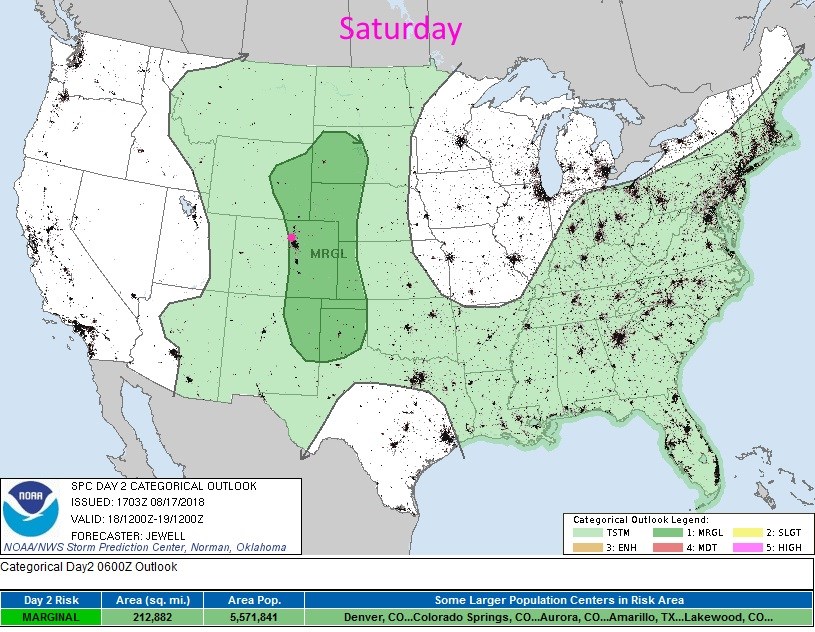
The SPC has painted us with a marginal risk of severe weather (hail, high winds, and locally flooding rains -and an isolate tornado is not out of the question today as well). The SPC is thinking about the need for a slight risk for parts of Colorado today (2 on a scale of 1-5).  I'll update this post if that happens. (Figure 4)

Figure 5 shows that cleaner air is flowing in with this southern air.  Hopefully we'll breath easier later today into Sunday.

Figure 1: the water vapor satellite image from Friday PM. Reds/Oranges are dry air, greys/whites are moist air regions. Green arrows show approx. moisture flow.

Figure 2: The 500mb forecast upper air analysis for Saturday AM. Pink dot is Longmont. Red lines are troughs, blue lines are ridges.

Figure 3: The forecast surface map for Saturday PM. From NCEP.

Figure 4: the day 2 SPC thunderstorm and severe weather forecast made Friday (valid Saturday).

Figure 5: The HRRR (high resolution rapid refresh) model forecast of smoke at all levels for Saturday noon.

The longer range forecast:

The trough passes Sunday and pushes a stout cold front down with it (Figure 6). After a wet Saturday in most locations, we still have lingering showers (green circle in Figure 7) through Sunday afternoon.  Overall, we experience a notable cool period from Saturday to Tuesday (blue circle in Figure 7).  After that, upper 80'sF return with afternoon storms always possible.

Figure 6: The 500mb forecast upper air analysis for Sunday AM. Pink dot is Longmont. Red lines are troughs, blue lines are ridges.

Figure 7: the next 10 days of the graphical forecast for Longmont, CO from weatherunderground.com

Current Weather

Partly sunny

Partly sunny

78°F

UV Index
4 Moderate
Pressure
29.83 Rising
Visibility
7 miles
Dewpoint
41 °F
Humidity
26%
Wind
WNW 9.1 mph
Gust
17 mph
Wind Chill
78 °F

Hourly Forecast

Today
4 PM
78°F
Showers
Today
5 PM
78°F
Intermittent clouds
Today
6 PM
76°F
Mostly sunny
Today
7 PM
75°F
Mostly sunny
Today
8 PM
71°F
Mostly sunny
Today
9 PM
68°F
Mostly clear
Today
10 PM
64°F
Mostly clear
Today
11 PM
61°F
Mostly clear
Tomorrow
12 AM
58°F
Mostly clear
Tomorrow
1 AM
57°F
Mostly clear
Tomorrow
2 AM
55°F
Mostly clear
Tomorrow
3 AM
54°F
Mostly clear

7 Day Forecast

Partly sunny w/ showers

Sunday

79 °F

Partly sunny with a brief shower or two this afternoon


Mostly clear

Sunday Night

49 °F

Breezy this evening; otherwise, mainly clear


Partly sunny w/ t-storms

Monday

71 °F

Not as warm with clouds and sunshine; a thunderstorm in spots in the afternoon


Thunderstorms

Monday Night

47 °F

Cloudy with a couple of thundershowers


Thunderstorms

Tuesday

59 °F

Mostly cloudy and cooler with a couple of showers and a thunderstorm, mainly later


Partly cloudy

Tuesday Night

37 °F

Partly cloudy


Partly sunny

Wednesday

70 °F

Partly sunny, pleasant and warmer


Mostly clear

Wednesday Night

40 °F

Mainly clear


Partly sunny

Thursday

82 °F

Warmer with partial sunshine


Mostly cloudy

Thursday Night

44 °F

Mostly cloudy


Sunrise and Sunset

Sunrise
5:41 AM
Sunset
8:14 PM

Based on AccuWeather data