Skip to content

The Next Storm/Next Snow Forecast Discussion from the Cherrywood Observatory – August 11th, 2018

This content was originally published by the Longmont Observer and is licensed under a Creative Commons license.

Forecast Discussion:

What are you doing here reading about the weather, instead of enjoying it outside?! It is warm to almost hot, but not too bad. Really clear blue skies returned. Winds are mild. It is really nice! (But I grew up in Phoenix... so this is typical Halloween to Thanksgiving Day weather to me.)

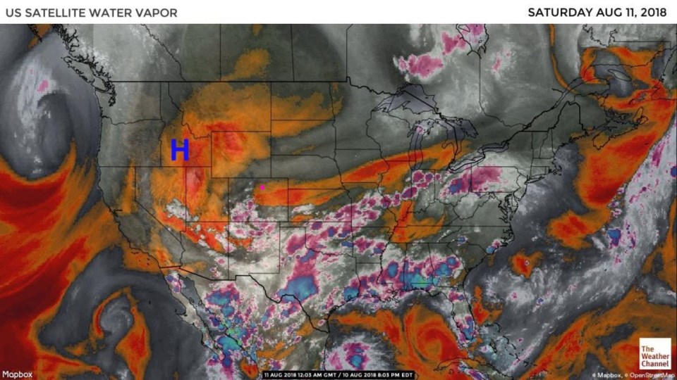
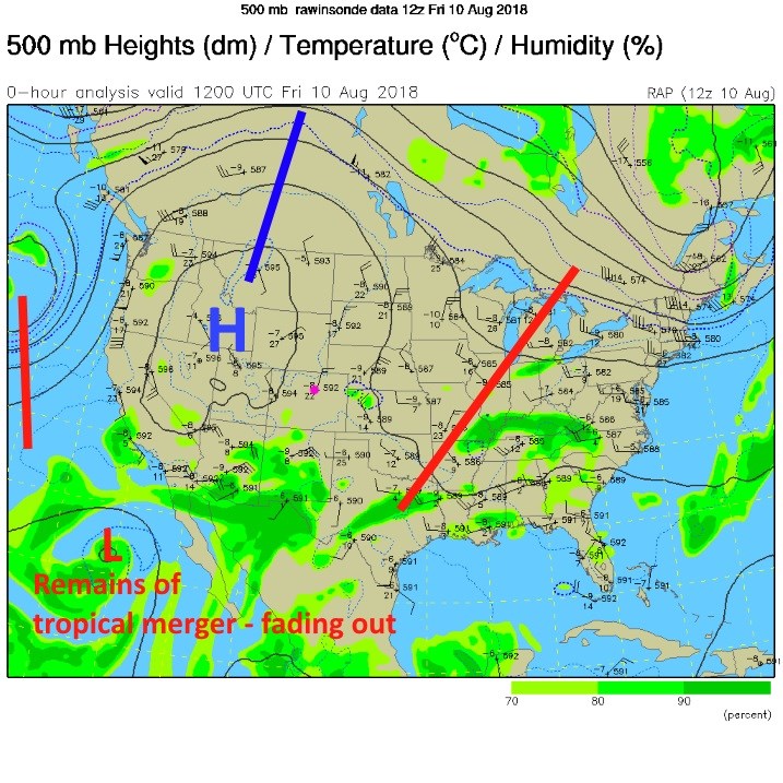
Briefly, Figure 1 shows the very dry air over northern Colorado (reds and oranges). The upper level high has become quite stout (the big blue H in Figure 2). You can catch a glimpse of the merged tropical systems way down in the southwest corner of the image.  That moisture might return next week with the next approaching (stronger) upper level trough.

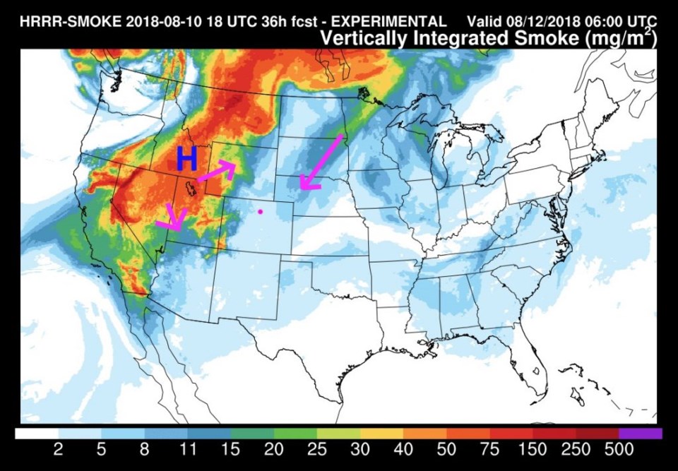
Smoke is thick off to the west and north of our state. It is currently very light over Colorado. I don't see it returning for a few days (Figure 3) at least.

Figure 1: the water vapor satellite image from Friday night. Reds/Oranges are dry air, greys/whites are moist air regions.

Figure 2: The 500mb upper air analysis for Friday PM. Pink dot is Longmont. Red lines are troughs, blue lines are ridges.

Figure 3: The HRRR (high resolution rapid refresh) model forecast of smoke at all levels for Saturday night.

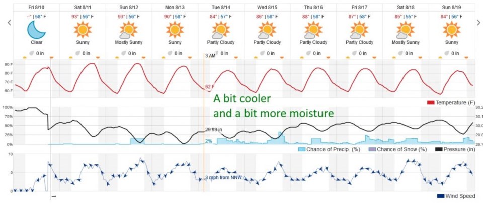
The longer range forecast:

There will be a tiny bit of moisture and a minor upper level short wave on Sunday that gives us a small chance of an afternoon storm (Figure 4) - but I wouldn't place bets on it. We hover around 90° F each day until that next upper level (stronger) trough approaches on Tuesday. We only drop to lower 80's F for a high and have a small increase in storm chances after that. It is just quiet!

Figure 4: the next 10 days of the graphical forecast for Longmont, CO from weatherunderground.com

Current Weather

Cloudy

Cloudy

36°F

UV Index
1 Low
Pressure
30.26 Rising
Visibility
7 miles
Dewpoint
32 °F
Humidity
88%
Wind
NNE 4.4 mph
Gust
8.1 mph
Wind Chill
33 °F

Hourly Forecast

Today
5 PM
40°F
Cloudy
Today
6 PM
39°F
Rain
Today
7 PM
38°F
Rain
Today
8 PM
37°F
Cloudy
Today
9 PM
36°F
Flurries
Today
10 PM
36°F
Cloudy
Today
11 PM
36°F
Rain and snow
Tomorrow
12 AM
36°F
Rain and snow
Tomorrow
1 AM
35°F
Cloudy
Tomorrow
2 AM
35°F
Snow
Tomorrow
3 AM
34°F
Flurries
Tomorrow
4 AM
34°F
Snow

7 Day Forecast

Rain and snow

Friday

41 °F

Chilly; rain and snow showers this morning with little or no accumulation followed by rain and drizzle this afternoon


Rain and snow

Friday Night

33 °F

Periods of snow; rain mixed in early, accumulating 1-3 inches; roads could be slippery


Flurries

Saturday

39 °F

A bit of morning snow with little or no accumulation; otherwise, cloudy and cold; storm total snowfall 1-3 inches


Intermittent clouds

Saturday Night

30 °F

A shower in places in the evening; otherwise, partly cloudy


Partly sunny

Sunday

64 °F

Partly sunny and warmer


Mostly clear

Sunday Night

41 °F

Mainly clear


Intermittent clouds

Monday

79 °F

Warmer with a blend of sun and clouds


Partly cloudy

Monday Night

40 °F

Partly cloudy


Mostly cloudy

Tuesday

66 °F

Mostly cloudy and not as warm


Mostly cloudy

Tuesday Night

40 °F

Mostly cloudy


Sunrise and Sunset

Sunrise
6:15 AM
Sunset
7:44 PM

Based on AccuWeather data