Skip to content

[Update 4/7 1PM] The Next Storm/Next Snow Forecast Discussion from the Cherrywood Observatory – April 7, 2018

This content was originally published by the Longmont Observer and is licensed under a Creative Commons license.

Forecast Discussion:

[Saturday 4/7 1pm Update- Post storm reports.]

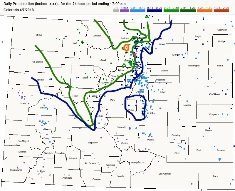
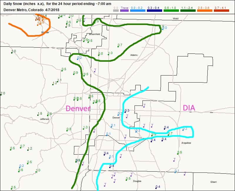
Figure 1 update shows the total water amounts (with rough division analysis of the amount binning generated by CoCoRaHS site) for the state. The northern mountains and northern front range definable won the water lottery this time!

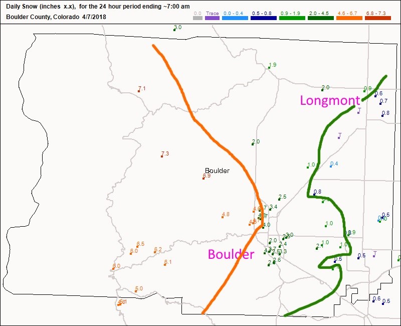
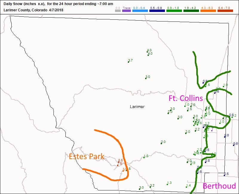
Figure 2 update has Longmont in the 'just below' one inch snowfall amounts.  The higher foothills picked up a nice 4-8 inches. Figure 3 update has Estes Park pulling a nice 5-7 inches of snow while the western sides of Ft. Collins and Loveland getting a couple of inches.

Figure 4 update shows Denver getting much less snow (it was too warm).  The Rockies baseball game was still held (for better or for worse). One had to go to the foothills to the west to get a reliable 1 inch of snow.

Figure 1 update: CoCoRaHS 24 hr precipitation reports up to 7am today for all of Colorado. Color contours try to outline large scale patterns based on the key colors.

Figure 2 update: CoCoRaHS 24 hr snow reports up to 7am today for Boulder Co.. Color contours try to outline large scale patterns based on the key colors.

Figure 3 update: CoCoRaHS 24 hr snow reports up to 7am today for Larimer Co.. Color contours try to outline large scale patterns based on the key colors.

Figure 4 update: CoCoRaHS 24 hr snow reports up to 7am today for the Denver Metro. Color contours try to outline large scale patterns based on the key colors.

[End UPDATE]

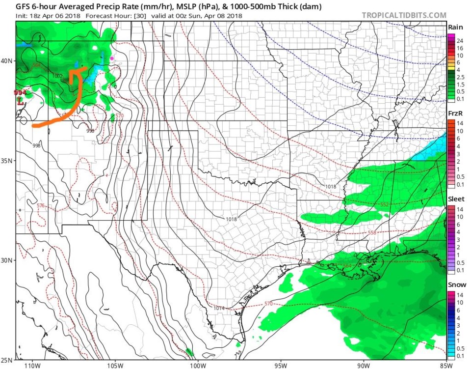
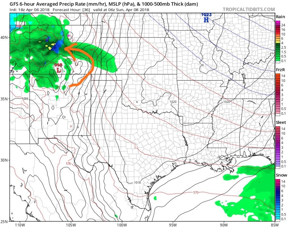
Our current weather event is underway so I'll keep this brief and update with snow/water reports midday today (Saturday).  The next round of showers, actually caused by an upper air trough (missing in the Friday/Saturday snow storm) as it passes- will increase rain chances around 6pm tonight and continuing through the night to about 6am to 8am Sunday. The low Sunday morning should be 35F - don't expect much snow. Figure 1 shows the storm approaching the Four Corners area this afternoon, pumping warm moist air into the mountains. By midnight tonight, the low is near Raton and Trinidad and is pushing warm moist air uphill further to the east.

Figure 1: The GFS forecast precipitation type and intensity for 6 hours around Saturday night 6pm from tropicaltidbits.com

Figure 2: The GFS forecast precipitation type and intensity for 6 hours around Saturday night; 12am Sunday from tropicaltidbits.com

The longer range forecast:

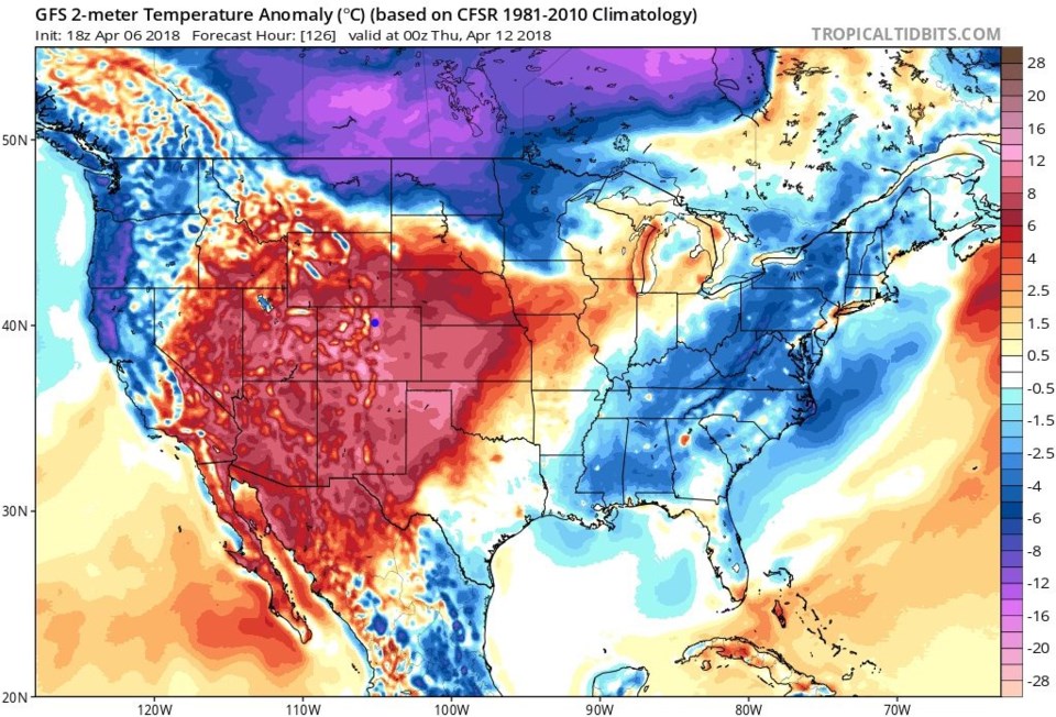
Next week looks very mild (and dry) with temperatures quite close to 80F for highs on Wednesday and Thursday. Figure 3 is an example of the surface temperature departure from normal.  Amazingly warm! Tune in tomorrow for snow totals (we've had 10 hours of snow but maybe 1/2 to 1 inch build up in some grassy locations--- the ground is quite warm).

Figure 3: The surface temperature anomaly for Wednesday night from the GFS and tropicaltidbits.com

Current Weather

Cloudy

Cloudy

55°F

UV Index
0 Low
Pressure
29.68 Rising
Visibility
8 miles
Dewpoint
41 °F
Humidity
59%
Wind
NW 2.9 mph
Gust
8.2 mph
Wind Chill
55 °F

Hourly Forecast

Today
11 PM
54°F
Thunderstorms
Tomorrow
12 AM
53°F
Cloudy
Tomorrow
1 AM
52°F
Cloudy
Tomorrow
2 AM
51°F
Cloudy
Tomorrow
3 AM
51°F
Cloudy
Tomorrow
4 AM
50°F
Cloudy
Tomorrow
5 AM
51°F
Cloudy
Tomorrow
6 AM
51°F
Cloudy
Tomorrow
7 AM
52°F
Cloudy
Tomorrow
8 AM
56°F
Cloudy
Tomorrow
9 AM
59°F
Cloudy
Tomorrow
10 AM
63°F
Mostly cloudy

7 Day Forecast

Mostly cloudy w/ showers

Thursday

72 °F

Turning cloudy, warm; an afternoon shower or two


Thunderstorms

Thursday Night

50 °F

A thunderstorm in parts of the area this evening; otherwise, considerable cloudiness and mild


Thunderstorms

Friday

70 °F

Mostly cloudy with a couple of thundershowers


Thunderstorms

Friday Night

43 °F

Cloudy with a couple of thundershowers


Rain

Saturday

46 °F

Chilly with periods of rain and a thunderstorm


Rain and snow

Saturday Night

39 °F

Cloudy with rain, mixed with a little snow late


Mostly cloudy

Sunday

59 °F

Mostly cloudy and warmer


Partly cloudy

Sunday Night

36 °F

Partly cloudy


Partly sunny

Monday

71 °F

Partly sunny, pleasant and warmer


Partly cloudy

Monday Night

42 °F

Partly cloudy


Sunrise and Sunset

Sunrise
6:07 AM
Sunset
7:50 PM

Based on AccuWeather data