Skip to content

The Next Storm/Next Snow Forecast Discussion from the Cherrywood Observatory – April 22, 2018

This content was originally published by the Longmont Observer and is licensed under a Creative Commons license.

Forecast Discussion and the Longer Range Forecast:

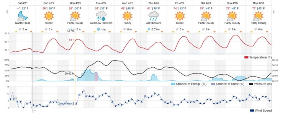
I need to catch up on some life with the passage of this storm, so I'll take the easy way out and just discuss the next 10 days at-a-glance with help from weatherunderground.com...

We warm immediately up to 70F today (Sunday) and experience wonderful weather.  We have another beautiful day on Monday before another cold front moves in around 2pm on Monday.  Temperatures drop and we have another (more substantial than originally forecast a couple of days ago) chance of rain ending with maybe a coating of snow on grassy surfaces and car tops again- Tuesday morning.  It will melt immediately again IF it happens as we warm to the 50'sF that day.  There is some indication of enough instability Monday night that we might see some rumbles of thunder.  A meteorologist can only hope.

More on the spring weather and small rain chances in the week beyond in tomorrow's update!

Figure 1: the 10 day graphical forecast for Longmont from weatherunderground.com

Current Weather

Partly sunny

Partly sunny

46°F

UV Index
2 Low
Pressure
29.58 Rising
Visibility
8 miles
Dewpoint
42 °F
Humidity
86%
Wind
WNW 2.3 mph
Gust
6.1 mph
Wind Chill
46 °F

Hourly Forecast

Today
8 AM
50°F
Cloudy
Today
9 AM
54°F
Cloudy
Today
10 AM
58°F
Cloudy
Today
11 AM
63°F
Cloudy
Today
12 PM
68°F
Cloudy
Today
1 PM
67°F
Mostly cloudy
Today
2 PM
70°F
Mostly cloudy
Today
3 PM
68°F
Mostly cloudy
Today
4 PM
67°F
Mostly cloudy
Today
5 PM
65°F
Cloudy
Today
6 PM
58°F
Thunderstorms
Today
7 PM
56°F
Thunderstorms

7 Day Forecast

Thunderstorms

Friday

70 °F

Mostly cloudy with a couple of thundershowers this afternoon; gusty winds and small hail can accompany any downpour


Thunderstorms

Friday Night

45 °F

Cloudy; a couple of showers and a thunderstorm this evening followed by periods of rain late; gusty winds and small hail can accompany any downpour


Rain

Saturday

48 °F

Chilly with periods of rain and a thunderstorm; travel in the foothills and mountains will be slippery due to snow


Rain and snow

Saturday Night

39 °F

Cloudy with rain, mixed with a little snow late; travel in the foothills and mountains will be slippery due to snow


Mostly cloudy

Sunday

59 °F

Mostly cloudy and warmer


Partly cloudy

Sunday Night

36 °F

Partly cloudy


Partly sunny

Monday

71 °F

Partly sunny, pleasant and warmer


Partly cloudy

Monday Night

45 °F

Partly cloudy


Mostly sunny

Tuesday

73 °F

Mostly sunny, breezy and pleasant


Partly cloudy

Tuesday Night

43 °F

Partly cloudy


Sunrise and Sunset

Sunrise
6:06 AM
Sunset
7:51 PM

Based on AccuWeather data