Skip to content

The Next Storm/Next Snow Forecast Discussion from the Cherrywood Observatory – April 16, 2018

This content was originally published by the Longmont Observer and is licensed under a Creative Commons license.

Forecast Discussion:

An interesting change has occurred in the models this morning concerning the week-end storm, but first we'll be warm today and chilly and windy tomorrow... let's look at it:

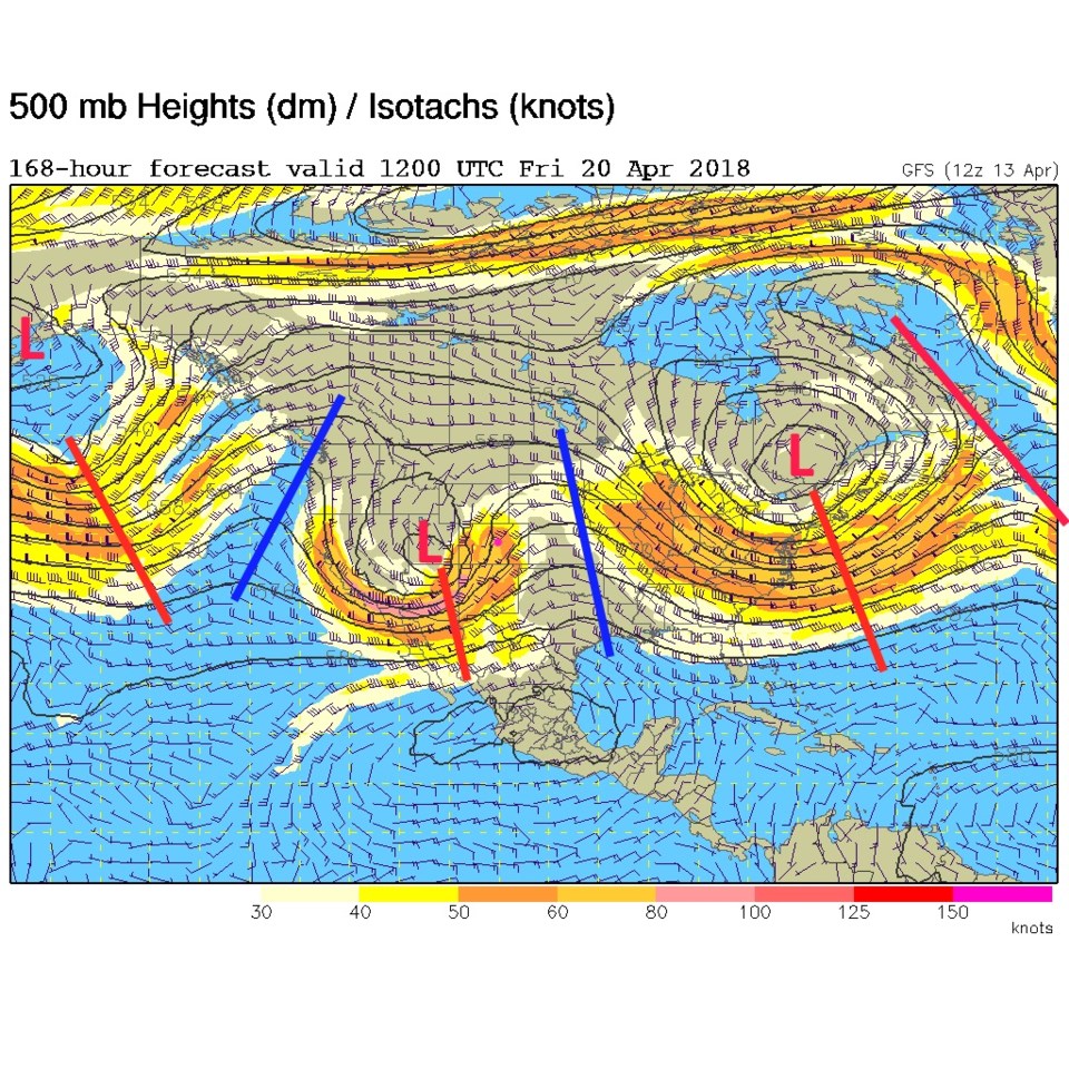
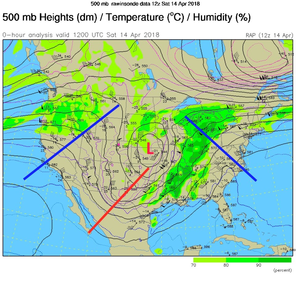
Figure 1 shows the upper air pattern from Sunday with the departing low and trough and the approaching ridge. That ridge passes overhead today making things quite warm (the fact that the wavelengths are shorter than the distance between the US east and west coast means they are on the move - progressing eastward).

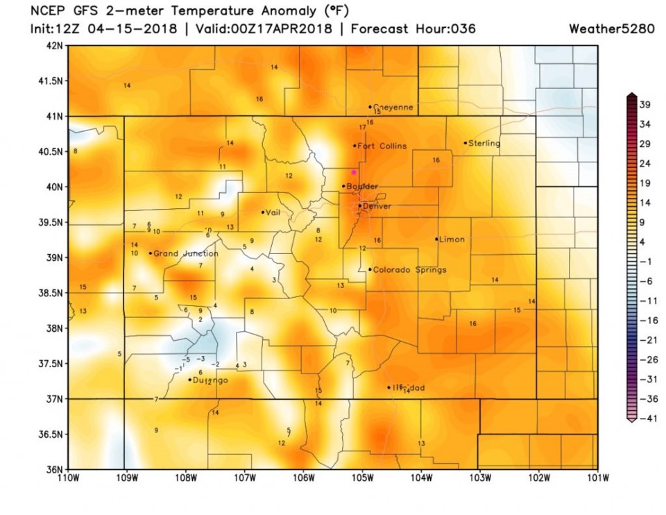
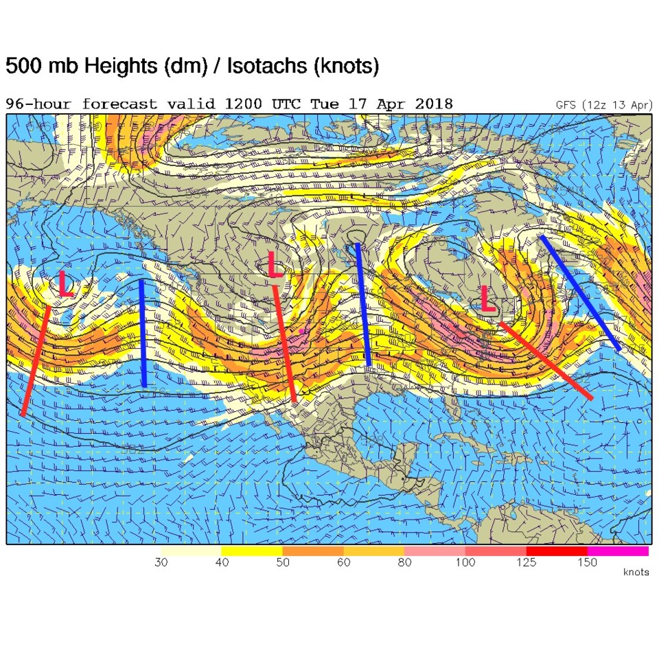
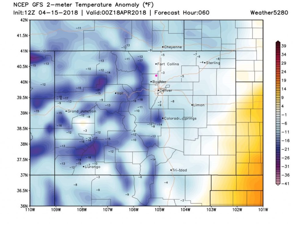
Figure 2 has Longmont some 18F above normal today!  Figure 3, the upper air map for tomorrow, shows the next trough here already here. Figure 4 is the temperature anomaly for Tuesday; Longmont is about 4 degrees below normal. An almost 20F drop in one day will be noticeable!

Figure 1: The 'current' 500mb upper air map from Sunday PM. Troughs = red lines, ridges = blue lines, Longmont = pink dot.

Figure 2: The forecast surface temperature anomaly (departure from normal) for Monday PM from the GFS and weather5280.com

Figure 3: The forecast 500mb upper air map for Tuesday AM from the GFS. Troughs = red lines, ridges = blue lines, Longmont = pink dot.

Figure 4: The forecast surface temperature anomaly (departure from normal) for Tuesday PM from the GFS and weather5280.com

The longer range forecast:

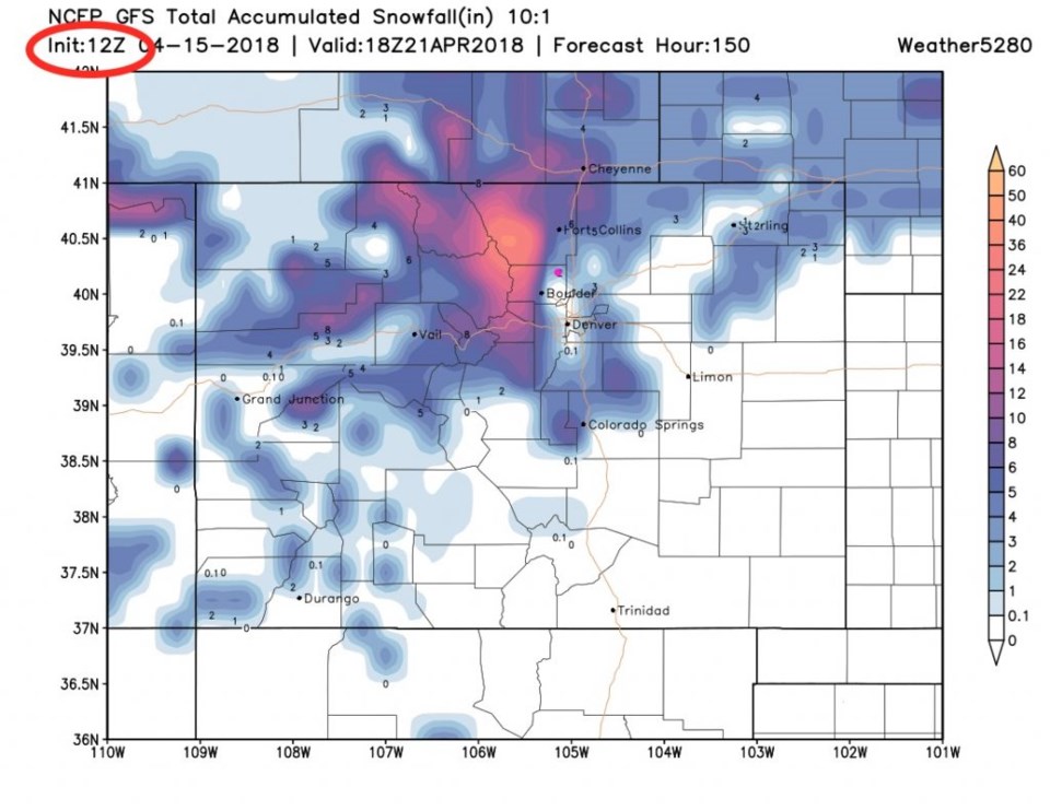
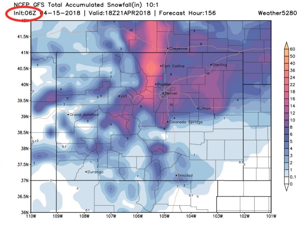
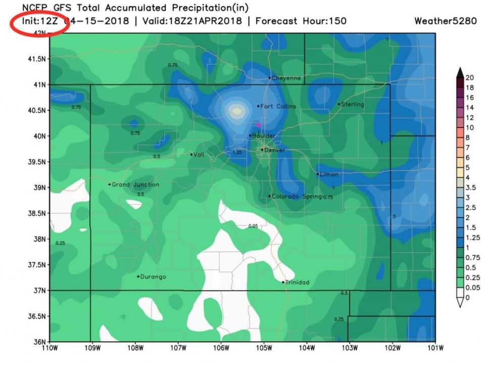
Figure 5 is the week-end storm.  Notice (like yesterday's discussion) how much further south the Low center is on that trough.  Colder, slower, and wetter is the story. But, as we can see in Figure 6 the model run from 6am on Sunday has Longmont only receiving a couple of inches of snow (and nothing just down in Niwot)-Figure 6.  Compare this to the model run at midnight Saturday into Sunday (Figure 7) and we were getting 8 inches or more.  Things are suddenly coming out MUCH warmer for this storm.  Back to the model run from later Sunday morning, we are still getting a lot of water (Figure 8) with Longmont getting 1.5 inches of rain or more.

We'll keep on this storm all week.

Figure 5: The forecast 500mb upper air map for Friday AM from the GFS. Troughs = red lines, ridges = blue lines, Longmont = pink dot.

Figure 6: the total snowfall between Sunday PM and midday Saturday from the GFS and weather5280.com from the computer run at 6am Sunday.

Figure 7: the total snowfall between Sunday PM and midday Saturday from the GFS and weather5280.com from the computer run at 12am Sunday.

Figure 8: the total precipitation between Sunday PM and midday Saturday from the GFS and weather5280.com from the computer run at 6am Sunday.

Current Weather

Mostly cloudy

Mostly cloudy

46°F

UV Index
0 Low
Pressure
29.57 Falling
Visibility
8 miles
Dewpoint
41 °F
Humidity
85%
Wind
SW 2.2 mph
Gust
5.6 mph
Wind Chill
46 °F

Hourly Forecast

Today
7 AM
52°F
Cloudy
Today
8 AM
55°F
Cloudy
Today
9 AM
60°F
Cloudy
Today
10 AM
62°F
Cloudy
Today
11 AM
65°F
Cloudy
Today
12 PM
68°F
Cloudy
Today
1 PM
67°F
Mostly cloudy
Today
2 PM
70°F
Mostly cloudy
Today
3 PM
68°F
Mostly cloudy
Today
4 PM
67°F
Mostly cloudy
Today
5 PM
65°F
Cloudy
Today
6 PM
58°F
Thunderstorms

7 Day Forecast

Thunderstorms

Friday

70 °F

Mostly cloudy with a couple of thundershowers this afternoon; gusty winds and small hail can accompany any downpour


Thunderstorms

Friday Night

45 °F

Cloudy; a couple of showers and a thunderstorm this evening followed by periods of rain late; gusty winds and small hail can accompany any downpour


Rain

Saturday

48 °F

Chilly with periods of rain and a thunderstorm; travel in the foothills and mountains will be slippery due to snow


Rain and snow

Saturday Night

39 °F

Cloudy with rain, mixed with a little snow late; travel in the foothills and mountains will be slippery due to snow


Mostly cloudy

Sunday

59 °F

Mostly cloudy and warmer


Partly cloudy

Sunday Night

36 °F

Partly cloudy


Partly sunny

Monday

71 °F

Partly sunny, pleasant and warmer


Partly cloudy

Monday Night

45 °F

Partly cloudy


Mostly sunny

Tuesday

73 °F

Mostly sunny, breezy and pleasant


Partly cloudy

Tuesday Night

43 °F

Partly cloudy


Sunrise and Sunset

Sunrise
6:06 AM
Sunset
7:51 PM

Based on AccuWeather data