Skip to content

The Next Storm/Next Snow Forecast Discussion from the Cherrywood Observatory – April 14, 2018

This content was originally published by the Longmont Observer and is licensed under a Creative Commons license.

Forecast Discussion and Long Range Forecast:

I'm going to take my family out on a date tonight and go light (lite) on the discussion today.  We'll look at storm reports tomorrow!

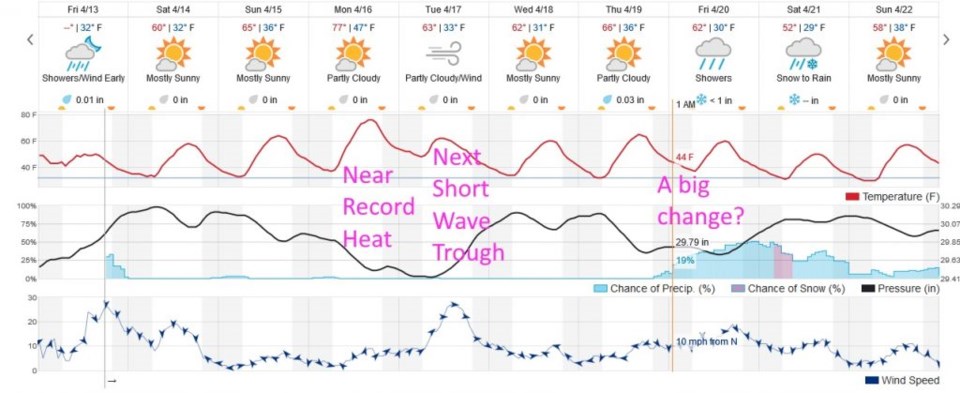
Figure 1 shows the next 10 days at a glance.  After the low retreats, as Saturday morning passes, winds will drop and temperatures begin to warm up.  An upper level ridge passes overhead on Monday warming us almost to 80F again. It is gone very quickly to be replaced by the next short wave trough. Winds kick up again on Tuesday and temperatures drop about 15F.  We warm up again for the end of the week before a (possible) extended period of rain chances begins around 1am Friday.

Not too unusual for a springtime around here!  See you tomorrow.

Figure 1: The 10 day graphical forecast from weather underground.com for Longmont.

Current Weather

Rain

Rain

53°F

UV Index
0 Low
Pressure
29.71 Rising
Visibility
7 miles
Dewpoint
43 °F
Humidity
68%
Wind
ENE 4.5 mph
Gust
9 mph
Wind Chill
53 °F

Hourly Forecast

Today
8 PM
56°F
Thunderstorms
Today
9 PM
53°F
Thunderstorms
Today
10 PM
50°F
Thunderstorms
Today
11 PM
48°F
Thunderstorms
Tomorrow
12 AM
46°F
Cloudy
Tomorrow
1 AM
46°F
Cloudy
Tomorrow
2 AM
45°F
Cloudy
Tomorrow
3 AM
44°F
Rain
Tomorrow
4 AM
44°F
Cloudy
Tomorrow
5 AM
44°F
Rain
Tomorrow
6 AM
44°F
Rain
Tomorrow
7 AM
44°F
Rain

7 Day Forecast

Mostly cloudy w/ t-storms

Friday

69 °F

Variable cloudiness with a couple of thundershowers this afternoon; gusty winds and small hail can accompany any downpour


Thunderstorms

Friday Night

41 °F

Cloudy; a couple of showers and a thunderstorm this evening followed by periods of rain late; gusty winds and small hail can accompany any downpour


Rain

Saturday

44 °F

Chilly with periods of rain and a thunderstorm; travel in the foothills and mountains will be slippery due to snow


Rain and snow

Saturday Night

36 °F

Cloudy with rain, mixed with a little snow late; travel in the foothills and mountains will be slippery due to snow


Mostly cloudy

Sunday

61 °F

Mostly cloudy and warmer


Intermittent clouds

Sunday Night

36 °F

A thunderstorm in spots in the evening; otherwise, partly cloudy


Partly sunny

Monday

71 °F

Partly sunny, pleasant and warmer


Partly cloudy

Monday Night

45 °F

Partly cloudy


Mostly sunny

Tuesday

73 °F

Pleasant with sunshine and patchy clouds


Partly cloudy

Tuesday Night

40 °F

Partly cloudy


Sunrise and Sunset

Sunrise
6:06 AM
Sunset
7:51 PM

Based on AccuWeather data