Skip to content

The Next Storm/Next Snow Forecast Discussion from the Cherrywood Observatory – April 1, 2018

This content was originally published by the Longmont Observer and is licensed under a Creative Commons license.

Forecast Discussion:

I'm up in Estes Park on a slower internet connection and am giving a general science talk at the Estes Park Memorial Observatory Saturday evening.  I also have stuff for Easter morning to have ready... so this must be brief this time.   I'm also releasing this early since the forecast for Easter sunrise (when many have outdoors services) had changed a bit.

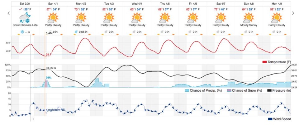
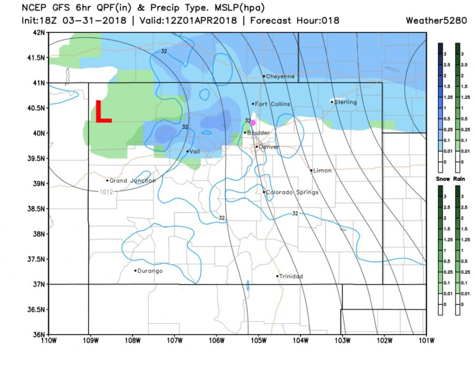
Figure 1 is the precipitation forecast for Sunday morning and there is more snow occurring across the northern Colorado tier of counties.  In Figure 2, the chance of precipitation at 5 to 7am is about 30%.  Take warm clothes and maybe an umbrella.

Figure 1: the 6 hour snapshot of surface pressures and precipitation Sunday morning from the GFS and weather5280.com

The longer range forecast:

After this really brief storm Sunday morning, things dry out and warm up quickly. We do have another chance of showers Tuesday AM (and temps drop) with the next front.  Beyond that --- more unsettled weather looks possible at the end of the week and beyond.

Happy Easter everyone!

Figure 2: The 10 day graphical forecast from weatherunderground.com for Longmont.

Current Weather

Sunny

Sunny

51°F

UV Index
3 Moderate
Pressure
30.19 Steady
Visibility
7 miles
Dewpoint
22 °F
Humidity
33%
Wind
NW 1.7 mph
Gust
3.9 mph
Wind Chill
51 °F

Hourly Forecast

Today
9 AM
52°F
Partly sunny
Today
10 AM
54°F
Intermittent clouds
Today
11 AM
56°F
Intermittent clouds
Today
12 PM
58°F
Intermittent clouds
Today
1 PM
59°F
Intermittent clouds
Today
2 PM
60°F
Mostly cloudy
Today
3 PM
62°F
Cloudy
Today
4 PM
61°F
Showers
Today
5 PM
59°F
Cloudy
Today
6 PM
57°F
Cloudy
Today
7 PM
54°F
Cloudy
Today
8 PM
52°F
Intermittent clouds

7 Day Forecast

Mostly cloudy w/ showers

Tuesday

62 °F

Cooler with some sun, then turning cloudy; a couple of afternoon showers


Partly cloudy w/ t-storms

Tuesday Night

39 °F

An evening thundershower; otherwise, partly cloudy


Mostly sunny

Wednesday

76 °F

Pleasant and warmer with sunshine and patchy clouds


Partly cloudy

Wednesday Night

41 °F

Patchy clouds


Mostly cloudy

Thursday

75 °F

Turning cloudy, warm; breezy, a thunderstorm around in the afternoon


Cloudy

Thursday Night

48 °F

Considerable cloudiness


Showers

Friday

69 °F

Mostly cloudy with a couple of showers


Thunderstorms

Friday Night

46 °F

Cloudy; thundershowers in the evening followed by periods of rain late


Showers

Saturday

53 °F

Cloudy and cooler with a couple of showers


Showers

Saturday Night

39 °F

Cloudy with occasional rain and drizzle late


Sunrise and Sunset

Sunrise
6:10 AM
Sunset
7:48 PM

Based on AccuWeather data