Skip to content

Update 4/1 8am: The Forecast Discussion from the Cherrywood Observatory –March 30-April 1, 2020

This content was originally published by the Longmont Observer and is licensed under a Creative Commons license.

In Brief:

A ripple in the upper level flow will kick off showers Monday afternoon with a few rumbles of thunder possible. We warm up and dry out wonderfully until a significant trough arrives Wednesday PM bringing rain back to the state. Cold air pours into the system on Thursday and another good hit of snow is possible Thursday into Thursday night. The weekend weather snaps temperatures back to 'warm' levels with dry conditions.

Update 4/1 8am:

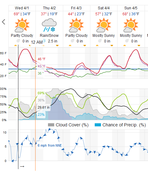
We can refine our forecast pretty well for the Thursday storm now that we've arrived at Wednesday. The chance of rain showers Wednesday afternoon/evening are lower than predicted a couple of days ago as the storm system has slowed a bit. The cold front won't arrive until Wednesday evening (Figure 1 udpate). We should see snow and snow showers most of the day Thursday (with some snow then rain showers Friday and (lesser) Saturday).

The jet stream will be contributing to the atmospheric uplift this time. We are expecting banded snow patterns. Longmont should receive 1-3 inches of snow (Figure 2 update) BUT if a band sets up over Boulder county - we could see that double. There will be snow winners and snow losers in our Thursday storm.

Figure 1 update: a snippet of the graphical forecast for the next 2 days for Longmont, CO from weatherunderground.com
Figure 2 update: 10:1 (snow to liquid) snowfall totals through the bext 5 days from the GFS and weather5280com for Colorado made Wednesday AM.

End update 4/1 8am

Forecast Discussion:

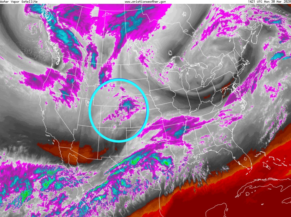
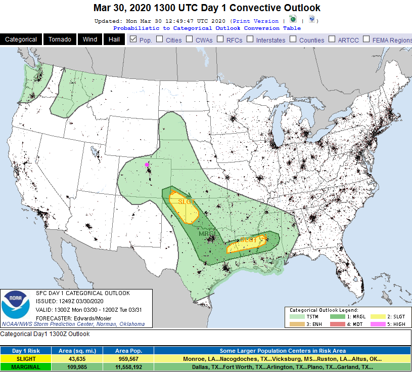
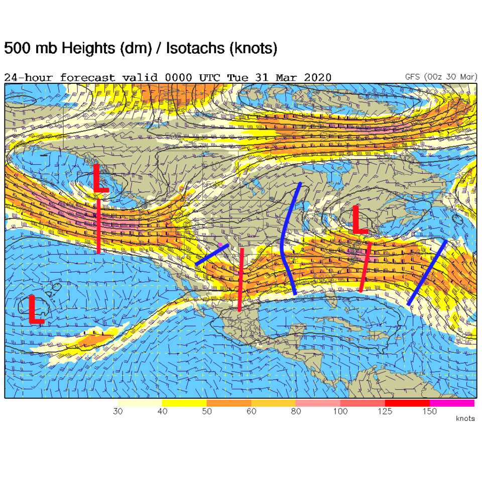
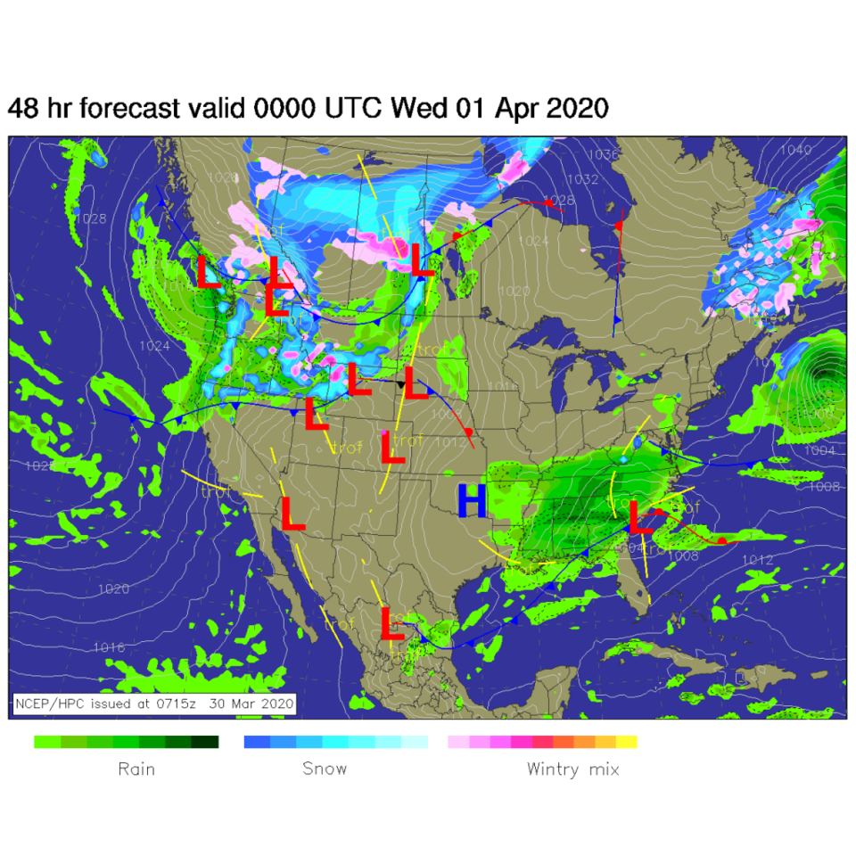
A short wave in the upper atmosphere is passing Monday. This is visible as enhanced/cold upper level clouds in Figure 1. Some showers are possible into the evening Monday. The SPC shows us that the cold air aloft could create enough instability for a few thunderstorms Monday (Figure 2). Later Monday - the trough (red line over eastern Colorado - Figure 3) is moving on to the east. The best chance of showers is in the afternoon (with peak daytime heating - Figure 4). That ridge behind the mini-trough moves in and we warm to the upper 60'sF to almost 70F Tuesday and Wednesday. Beautiful again (Figure 6).

The Longer Range Forecast:

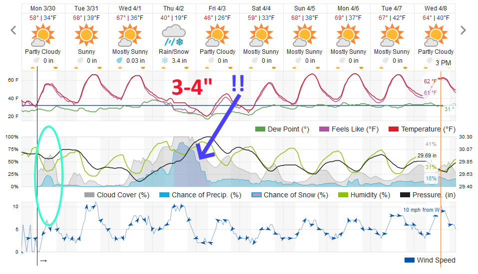
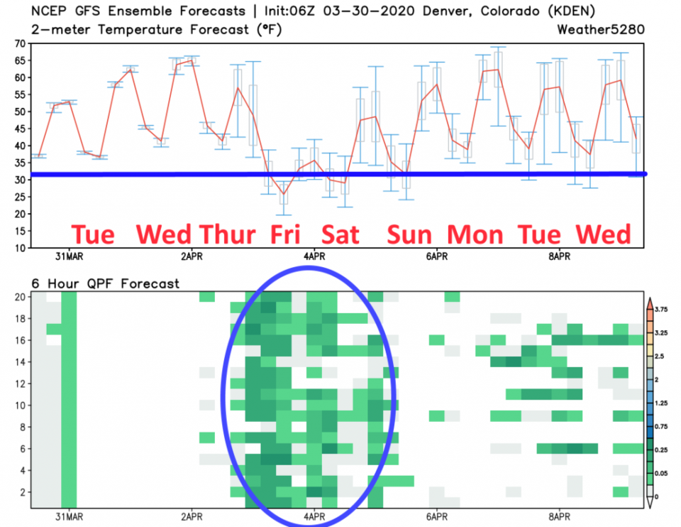
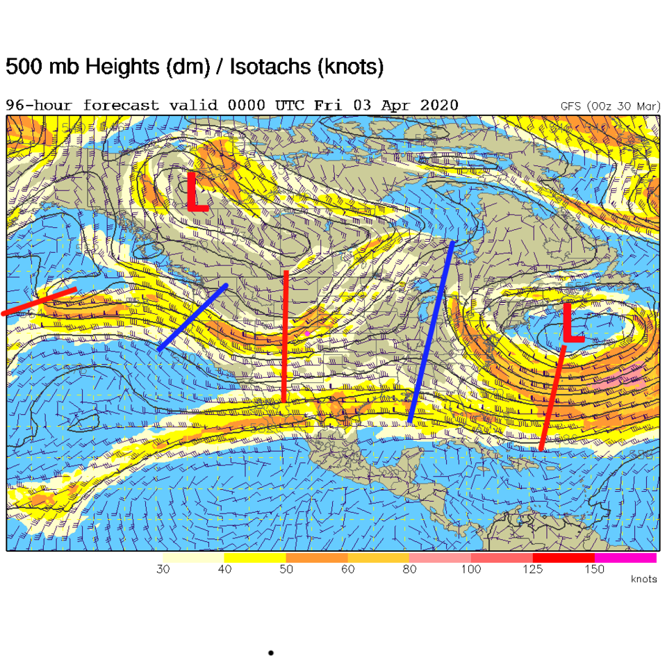
The next big story is coming in the form of a big wave and cold air that will pour out of the arctic (most of it remaining to our north and northeast this week - Figure 7). The weatherunderground model shows rainfall chances increasing midday Wednesday into Thursday morning (Figure 4). The GFS is really hopping onboard with this storm Wednesday afternoon to Friday morning (Figure 5). Note that temperatures drop below and hover near freezing Friday and Saturday morning (Figure 5).

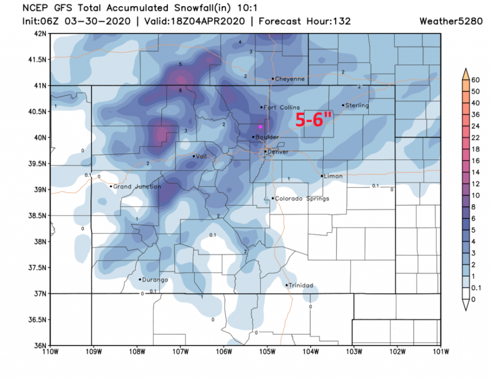
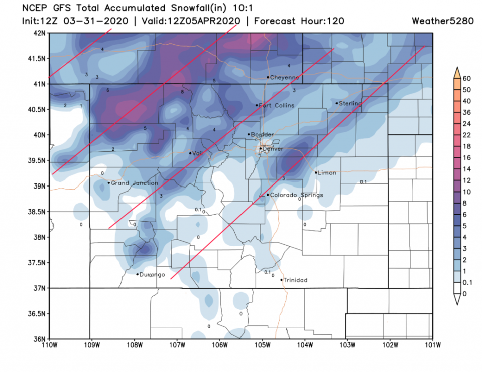
The GFS gives us an impressive 5-6 inches of snow by Saturday midday (Figure 8).
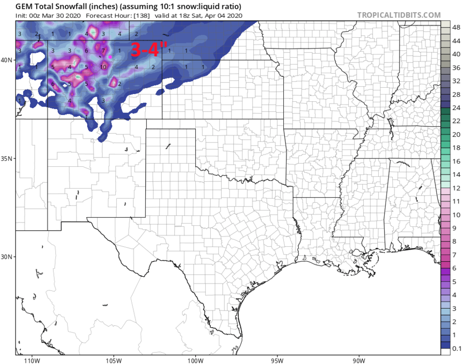
The GEM is similar but a bit below that at 3-4 inches (Figure 9).
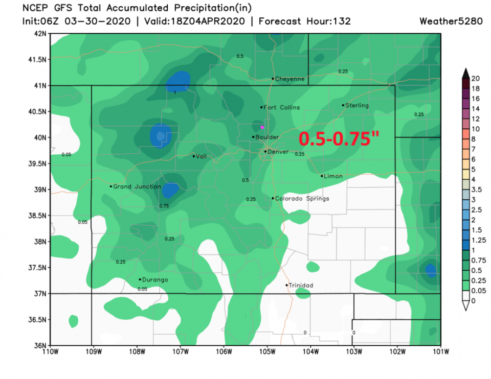
The total amount of water we may get seems to be in the 0.5 to 0.75 inch area (Figure 10).

Note, this is the 4th Friday-ish snow/rain cold snap we've had (starting with the Friday the 13th storm that gave us some snow). That happens, sometimes... the atmosphere settles into a 1 week long repeating pattern. Interesting!

Figure 1: the water vapor satellite image (browns/reds are dry air, whites and light grey is moist air, purple/blue is ice and high cloud tops). From the the NWS from Monday AM.
Figure 2: the Monday convection and severe weather chances for Wednesday from the SPC in Norman, OK.
Figure 3: The 500mb forecast upper air analysis for Monday PM. Pink dot is Longmont. Red lines are troughs, blue lines are ridges.
Figure 4: the graphical forecast for the next 10 days for Longmont, CO from weatherunderground.com
Figure 5: The ensemble GFS 10 day weather graph from weather5280.com
Figure 6: The forecast surface map for Tuesday PM from NCEP.
Figure 7: The 500mb forecast upper air analysis for Thursday PM. Pink dot is Longmont. Red lines are troughs, blue lines are ridges.
Figure 8: 10:1 (snow to liquid) snowfall totals through Saturday noon from the GFS and weather5280com for Colorado made Monday AM.
Figure 9: 10:1 (snow to liquid) snowfall totals through noon Saturday from the GEM and weather5280com for Colorado made Monday morning.
Figure 10: precipitation totals through Saturday noon from the GFS and weather5280com for Colorado made Monday AM.

Current Weather

Cloudy

Cloudy

50°F

UV Index
0 Low
Pressure
29.9 Steady
Visibility
7 miles
Dewpoint
45 °F
Humidity
83%
Wind
NNW 1.1 mph
Gust
3.7 mph
Wind Chill
50 °F

Hourly Forecast

Today
7 AM
51°F
Partly sunny
Today
8 AM
51°F
Partly sunny
Today
9 AM
59°F
Partly sunny
Today
10 AM
65°F
Intermittent clouds
Today
11 AM
71°F
Intermittent clouds
Today
12 PM
75°F
Intermittent clouds
Today
1 PM
77°F
Intermittent clouds
Today
2 PM
75°F
Thunderstorms
Today
3 PM
73°F
Cloudy
Today
4 PM
73°F
Cloudy
Today
5 PM
72°F
Cloudy
Today
6 PM
68°F
Cloudy

7 Day Forecast

Mostly cloudy w/ t-storms

Thursday

77 °F

Turning cloudy, warm; breezy, a stray thunderstorm this afternoon


Thunderstorms

Thursday Night

47 °F

A thunderstorm in spots this evening; otherwise, considerable cloudiness


Thunderstorms

Friday

69 °F

Mostly cloudy and not as warm with a couple of thundershowers


Thunderstorms

Friday Night

44 °F

Cloudy with a couple of thundershowers


Rain

Saturday

46 °F

Chilly with periods of rain and a thunderstorm


Rain and snow

Saturday Night

39 °F

Cloudy with rain, mixed with a little snow late


Mostly cloudy

Sunday

59 °F

Mostly cloudy and warmer; a stray afternoon thundershower


Partly cloudy

Sunday Night

36 °F

Partly cloudy


Mostly sunny

Monday

71 °F

Mostly sunny and warmer


Partly cloudy

Monday Night

39 °F

Partly cloudy


Sunrise and Sunset

Sunrise
6:07 AM
Sunset
7:50 PM

Based on AccuWeather data