This content was originally published by the Longmont Observer and is licensed under a Creative Commons license.
In Brief:
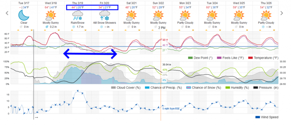
We have one more warm (very warm) and beautiful day Wednesday. Get out and take a walk! Showers move in Wednesday night (with some thunder?), become pretty heavy Thursday morning, then change to snow midday Thursday with snow lasting through Friday afternoon. We warm up and dry out through the weekend and into next week.
OH, I forgot to say Happy Spring - we are located at the Spring equinox at 9:50pm M.T. Thursday, March 19.
Update 3/19 9:45am:
The forecast is still on track. A healthy rainfall changed to snow at 9:45am. The winter storm warning for the 'rest' of Longmont is still in place. Here is the Thursday morning text on this warning (it runs a bit longer now).
Winter Storm Warning Issued: 11:39 AM Mar. 19, 2020 – National Weather Service
...WINTER STORM WARNING NOW IN EFFECT UNTIL 6 AM MDT FRIDAY...

* WHAT...Heavy snow. Additional snow accumulations of 6 to 12
inches. Winds gusting as high as 40 mph.

* WHERE...Denver, Boulder and the western suburbs of Denver.

* WHEN...Until 6 AM MDT Friday.

* IMPACTS...Plan on snow and slush covered roads. Blowing snow
will significantly reduce visibility. The combination of
treacherous road conditions and poor visibility will result in
difficult travel. The hazardous conditions will impact the
afternoon and evening commuting period. Strong winds and heavy
snow could cause power line and tree damage.

PRECAUTIONARY/PREPAREDNESS ACTIONS...

If you must travel, keep an extra flashlight, food, and water in
your vehicle in case of an emergency.

The latest road conditions for the state you are calling from can
be obtained by calling 5 1 1.
End update 3/19 9:45am.
Update 3/18 9pm:
One big question going into the morning is when will rain change to snow. The warnings begin at 9am. The GFS shows it happening between 11am and noon. Impressive snow amounts are still on the way. The weathe5280.com forecasters have released their hand-drawn forecast (Figure 1 update). The current watches and warnings are in Figure 2 update.
End 3/28 9pm update.
Update 3/18 7:30pm:
Amazingly the NWS has further upgraded our winter weather alerts (technically covering Longmont up to County Road 1... that is much of our town. Main Street is just a few miles west. We are on the edge of (or inside of) a Blizzard Warning now.
Blizzard Warning Issued: 1:02 PM Mar. 18, 2020 – National Weather Service
...BLIZZARD WARNING IN EFFECT FROM 9 AM THURSDAY TO 6 AM MDT
FRIDAY...

* WHAT...Blizzard conditions expected. Total snow accumulations
of 3 to 7 inches. Winds gusting as high as 55 mph.

* WHERE...Portions of east central and northeast Colorado.

* WHEN...From 9 AM Thursday to 6 AM MDT Friday.

* IMPACTS...Plan on snow and slush covered roads. Blowing snow
will significantly reduce visibility. The combination of
treacherous road conditions and poor visibility will result in
difficult to impossible travel. The hazardous conditions will
impact the evening commute. Strong winds and heavy snow could
cause power line and tree damage.

PRECAUTIONARY/PREPAREDNESS ACTIONS...

Travel should be restricted to emergencies only. If you must
travel, have a winter survival kit with you. If you get stranded,
stay with your vehicle.

The latest road conditions for the state you are calling from can
be obtained by calling 5 1 1.
End 3/18 7:30pm update:
Update 3/18 1pm:
The event is shaping up to be on the serious end of the forecast. We are now under a winter storm warning. Note this will be a very heavy wet snow.
Winter Storm Warning Issued: 3:02 PM Mar. 18, 2020 – National Weather Service
...WINTER STORM WARNING IN EFFECT FROM 9 AM THURSDAY TO 6 AM MDT
FRIDAY...

* WHAT...Heavy snow expected. Total snow accumulations of 4 to 10
inches. Winds gusting as high as 40 mph.

* WHERE...Fort Collins, Boulder and the western suburbs of
Denver and Denver.

* WHEN...From 9 AM Thursday to 6 AM MDT Friday.

* IMPACTS...Plan on snow and slush covered roads. Blowing snow
will significantly reduce visibility. The combination of
treacherous road conditions and poor visibility will result in
difficult to impossible travel. The hazardous conditions will
impact the evening commute. Strong winds and heavy snow could
cause power line and tree damage.

PRECAUTIONARY/PREPAREDNESS ACTIONS...

If you must travel, keep an extra flashlight, food, and water in
your vehicle in case of an emergency.

The latest road conditions for the state you are calling from can
be obtained by calling 5 1 1.
End update 3/18 1pm.
Forecast Discussion:
Let's start with the National Weather Service watch...:
NWS: Winter Storm Watch CANCELED and replace by the WARNING above:
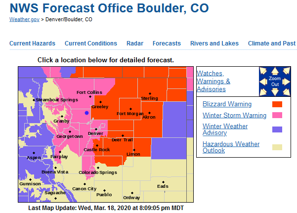
Area included in alert: Central and East Adams and Arapahoe Counties; Central and South Weld County; Morgan County; Sedgwick County; Washington County; Logan County; Larimer County Below 6000 Feet/Northwest Weld County; Phillips County; Boulder And Jefferson Counties Below 6000 Feet/West Broomfield County; North Douglas County Below 6000 Feet/Denver/West Adams and Arapahoe Counties/East Broomfield County; Elbert/Central and East Douglas Counties Above 6000 Feet; Northeast Weld County; North and Northeast Elbert County Below 6000 Feet/North Lincoln County See Figure 0.
Alert brief: Winter Storm Watch issued March 17 at 8:34PM MDT until March 20 at 6:00AM MDT by NWS Denver CO...SNOW, STRONG WINDS TO IMPACT NORTH-CENTRAL AND NORTHEAST COLORADO WEDNESDAY NIGHT THROUGH FRIDAY MORNING...
A storm system moving over Colorado Wednesday night through Friday morning will bring moderate to heavy snowfall along with wind gusts up to 45 mph. This will create hazardous travel conditions especially Thursday afternoon through Friday morning. The strongest winds will occur just east of I-25, while the heaviest snow may occur in and near the Front Range Foothills and Palmer Divide. Stay tuned to the National Weather Service for the latest updates regarding this storm.
* WHAT...Heavy snow possible. Total snow accumulations of 3 to 7 inches possible, with upwards of 10 inches over the Palmer Divide area. Winds could gust as high as 45 mph.
* WHERE...Portions of east central, north central and northeast Colorado.
* WHEN...From Thursday morning through late Thursday night.
* IMPACTS...Plan on slippery road conditions. Areas of blowing snow could significantly reduce visibility. The hazardous conditions could impact the evening commute.
* ADDITIONAL DETAILS...Rain will develop late Wednesday night and early Thursday morning, and then change over to heavy, wet snow from mid morning through the early afternoon hours.
______________________________________________
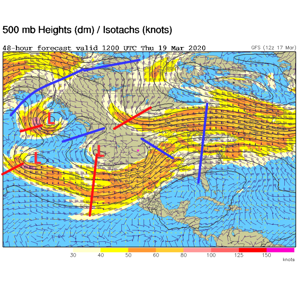
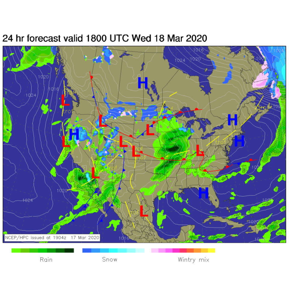
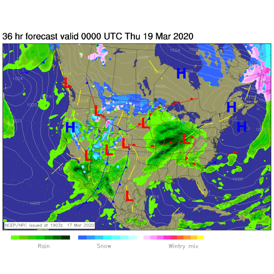
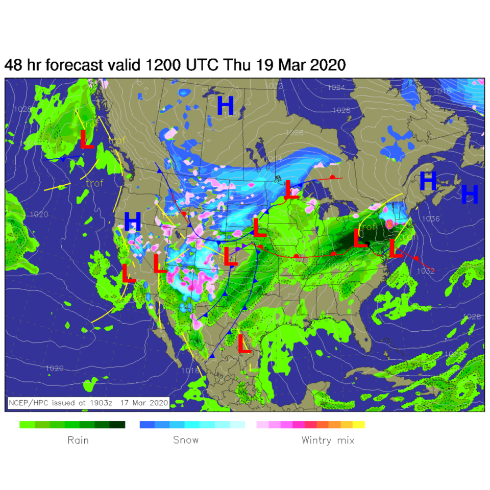
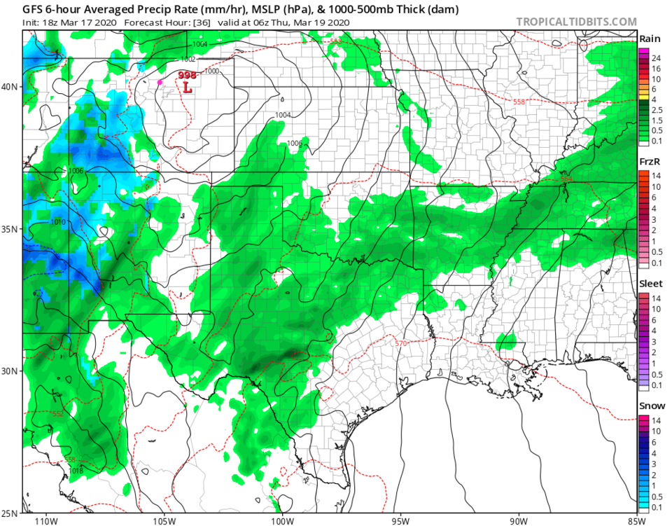
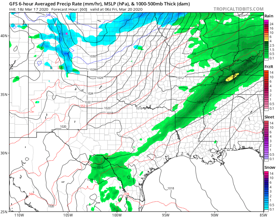
The trough is becoming pretty complex to our west, but a strong piece of the upper level energy will pass over the state Wednesday night into Friday afternoon (Figure 1). Wednesday noon we are still dry with the front just passing over the spine of the Rockies (Figure 2). By Wednesday PM, rainfall is moving out onto the plains as a secondary low begins to deepen around the four corners area. A LOT of moisture is hitting the western U.S. states (Figure 3). By Thursday AM - that low is to our east on the Plains and is bringing down colder air, turning the rain to snow, and blasting us with cold wet winds (Figure 4).
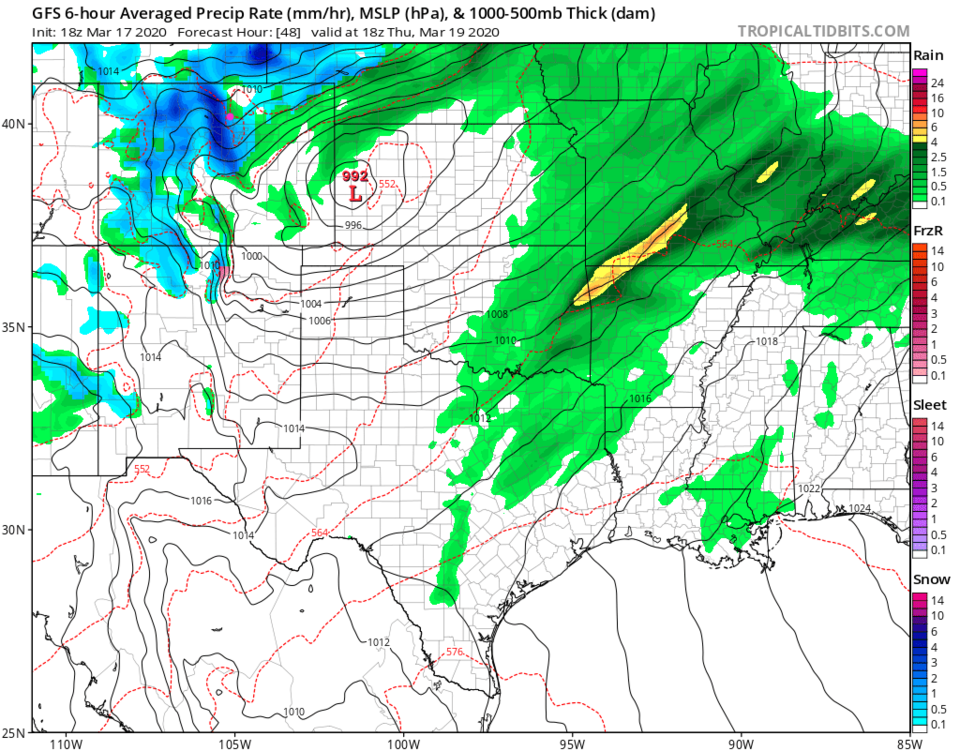
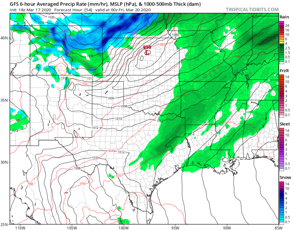
Going frame by frame, early Thursday AM, the low is organizing to our east (Figure 5) and moisture is abundant to our west, south and southeast. By Thursday noon, the rain is changing to snow that is very heavy in the foothills just a few miles to our west (Figure 6). By Thursday PM, snow continues, heavy in places (Figure 7). Friday early morning, up slope snow continues on into Friday morning, at least.
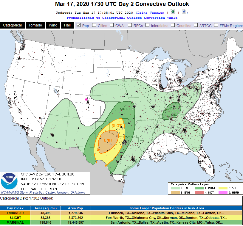
We might hear some thunder around the Front Range Wednesday PM, but the SPC (Storm Prediction Center) only has storms forming a few 10's of miles to our east (Figure 9).
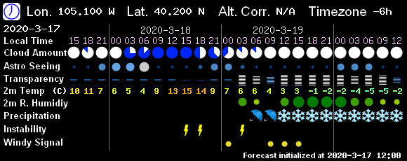
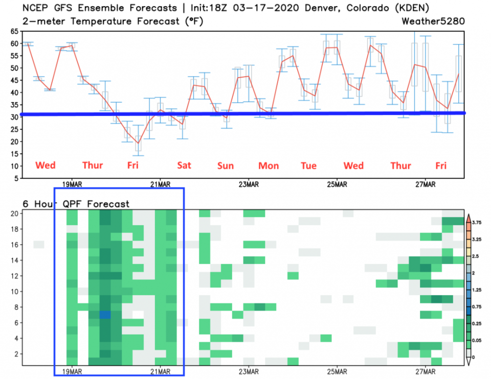
For timing, the GFS has some convection chances late Wednesday night (Figure 10), rain chances in the morning changing to snow at noon. The weatherunderground.com model has rain chances start late, around 11pm, then change to snow around 2pm Thursday (Figure 11). The ensemble model has a shot of rain late Wednesday PM, followed by good rain then snow chances Thursday. With more showers Friday evening, late (Figure 12).
Snowfall Roundup:
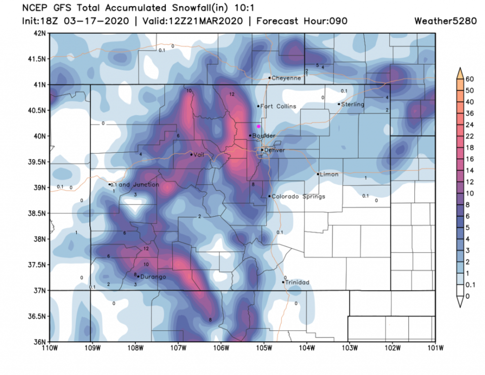
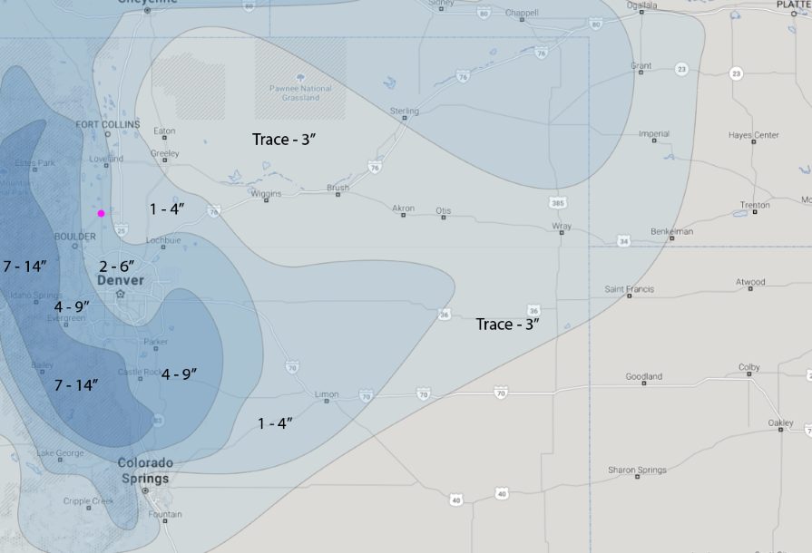
The GFS only gives us 1-2 inches (but the foothills get 1 to 1.5 feet of snow (Figure 13).
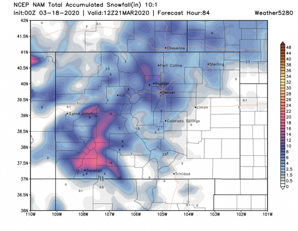
The NAM gives us 4-7 inches (with no big increase in the foothills - figure 14).
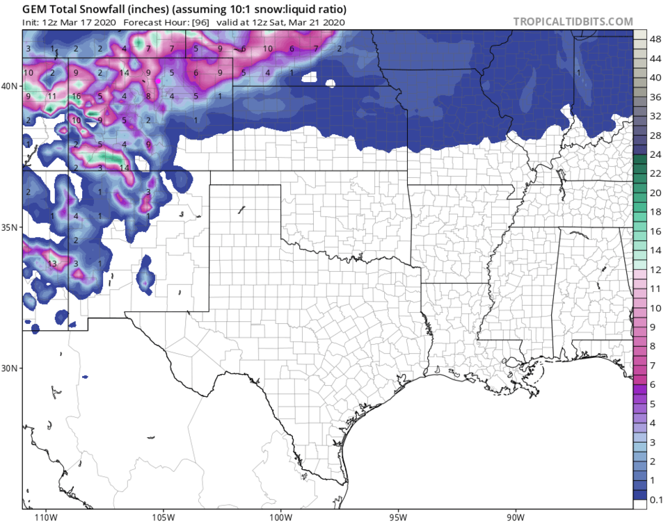
The GEM gives us 3-4 inches of snow with 9-10 in the foothills (Figure 15).
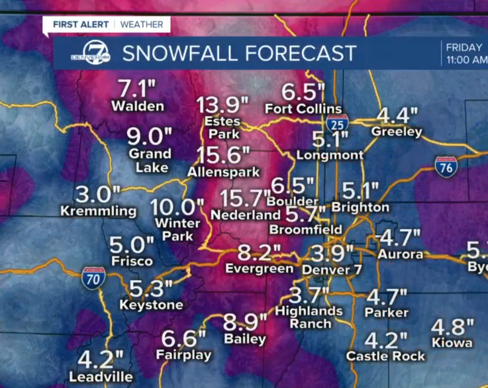
Channel 7 Denver gives us a very specific 5.1 inches of snow (Figure 16).
The NWS gives us (broadly) 3-7 inches of snow.
I'm calling for 3-5 inches, personally. Temperatures are still pretty warm.
The Longer Range Forecast:
Things return to warm and boring very quickly on Saturday with 60's F on the near horizon. It is nice to get some more water!