This content was originally published by the Longmont Observer and is licensed under a Creative Commons license.
10AM UPDATE straight from the mouth of the NWS:
Winter Storm Watch
URGENT - WINTER WEATHER MESSAGE National Weather Service Denver CO 437 AM MDT Tue Apr 9 2019
...STRONG WINTER STORM EXPECTED TO MOVE IN WEDNESDAY AFTERNOON... .Very warm temperatures are expected on Tuesday, ahead of a developing upper level storm system moving over the Great Basin. Drastic changes in the weather are expected to occur on Wednesday. A strong cold front will race across northeast Colorado Wednesday which will bring much colder temperatures, strong north winds and heavy snow. Areas of heaviest snowfall are still uncertain at this time and my occur anywhere from the Front Range to the far eastern plains. Residents of northeast Colorado should begin making preparations for this developing storm to avoid being caught by harsh winter conditions.

 The Northern Front Range Foothills- The Southern Front Range Foothills- Including the cities of Estes Park, Glendevey, Nederland, Red Feather Lakes, Bailey, Central City, Evergreen, Georgetown, Idaho Springs, and Westcreek

437 AM MDT Tue Apr 9 2019 ...WINTER STORM WATCH IN EFFECT FROM WEDNESDAY MORNING THROUGH THURSDAY MORNING...
* WHAT...Heavy snow and blowing snow possible. Total snow   accumulations of 5 to 10 inches possible. A few locations may   see greater than a foot of snow. Winds could gust as high as 45 mph.
* WHERE...The Northern Front Range Foothills and The Southern   Front Range Foothills.
* WHEN...From Wednesday morning through Thursday morning.
* ADDITIONAL DETAILS...Travel could become very difficult. Areas   of blowing snow could significantly reduce visibility. The   hazardous conditions could impact the morning and evening   commutes. Road closures could limit travel options by   Wednesday night. Strong winds could cause tree damage and   power outages.

PRECAUTIONARY/PREPAREDNESS ACTIONS... A Winter Storm Watch means there is potential for significant snow, sleet or ice accumulations that may impact travel. Continue to monitor the latest forecasts.


Hazardous Weather Outlook

Hazardous Weather Outlook National Weather Service Denver/Boulder CO 607 AM MDT Tue Apr 9 2019 COZ030>051-101215- Jackson County Below 9000 Feet- West Jackson and West Grand Counties Above 9000 Feet- Grand and Summit Counties Below 9000 Feet- South and East Jackson/Larimer/North and Northeast Grand/ Northwest Boulder Counties Above 9000 Feet- South and Southeast Grand/West Central and Southwest Boulder/ Gilpin/Clear Creek/Summit/North and West Park Counties Above 9000 Feet-Larimer and Boulder Counties Between 6000 and 9000 Feet- Jefferson and West Douglas Counties Above 6000 Feet/Gilpin/Clear Creek/Northeast Park Counties Below 9000 Feet- Central and Southeast Park County- Larimer County Below 6000 Feet/Northwest Weld County- Boulder And Jefferson Counties Below 6000 Feet/West Broomfield County- North Douglas County Below 6000 Feet/Denver/West Adams and Arapahoe Counties/East Broomfield County- Elbert/Central and East Douglas Counties Above 6000 Feet- Northeast Weld County-Central and South Weld County-Morgan County- Central and East Adams and Arapahoe Counties- North and Northeast Elbert County Below 6000 Feet/North Lincoln County- Southeast Elbert County Below 6000 Feet/South Lincoln County- Logan County-Washington County-Sedgwick County-Phillips County-

607 AM MDT Tue Apr 9 2019 ...Winter Storm Watch for most of north central and northeast Colorado for Wednesday through Thursday morning... This hazardous weather outlook is for northeast and north central Colorado.

.DAY ONE...Today and Tonight It will be very warm and dry today ahead of a strong spring storm. Record highs will be possible over northeast Colorado with highs near 80 degrees. Gusty southwest winds over parts of the plains combined with the low humidities will result red flag conditions.

.DAYS TWO THROUGH SEVEN...Wednesday through Monday A strong storm will move across Colorado Wednesday into Thursday with heavy snow expected across much of north central and northeastern Colorado. The precipitation will start out as rain on the plains Wednesday morning and quickly change over to snow during the afternoon behind the passage of a strong cold front. Strong winds behind the front combined with heavy snow at times may produce blizzard conditions across portions of the Plains and Palmer Divide from Wednesday afternoon through noon Thursday. Snowfall amounts could be significant in some places with this storm, so stay tuned for further updates. A gradual warming trend is expected Friday through Monday with a chance of showers mainly across the high country.
End 10 AM update.
Forecast Discussion:
HOLD THE PRESSES! The forecasted storm track has jogged south of the path it has been on for a few days. There is still time for the storm to wiggle north or south, but for the moment, a much more direct hit is expected.
In short - near-blizzard conditions, a nearly 50°F drop in temperature over 48 hours and significant rain and snow are possible Wednesday into Thursday.
Now to the details...
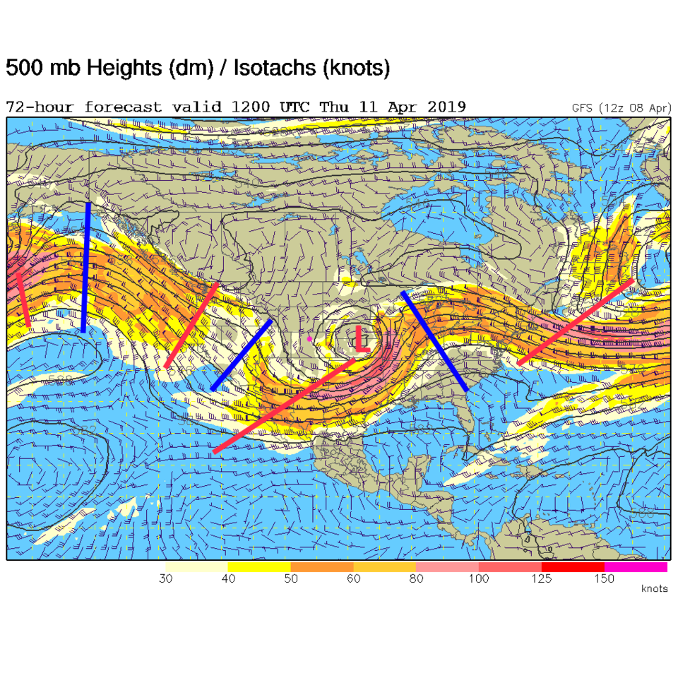
Before the storm, we have a strong ridge overhead, southwest flow, down-slope flow, and surface high pressure over the state (Figure 1). This all leads to temperatures Tuesday in the lower 80's F - some 22°F above normal (Figure 2). Even the weatherunderground model sends us up to 80°F (Figure 3).
This is the heat before the cold we are accustomed to in our state.
The longer range forecast:
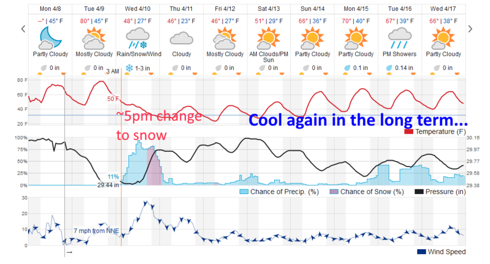
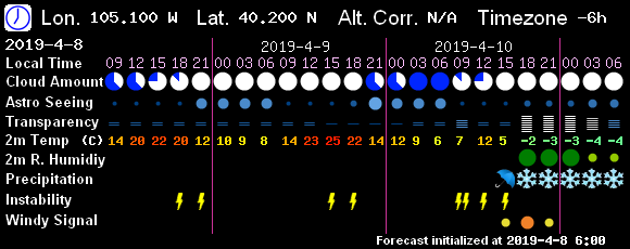
The next storm is ushered in with a cold front after midnight Wednesday early morning. Rain chances start right away in the warm air (Figure 3). Rain and thunderstorms are possible all day then a reinforcing shot of cold air (the real cold front) pours down and the rain is expected to change to snow around 5 pm (uh oh, the evening commute). Figure 4 holds off on the rain until around midday but starts the snow at about the same time as the weatherunderground.com model does.
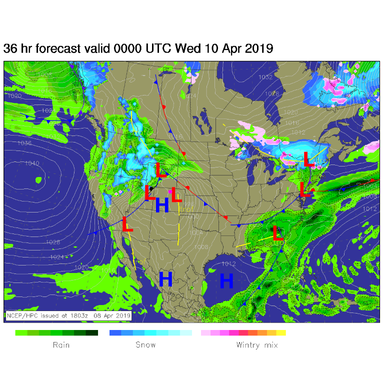
The low center aloft, that was up in Wyoming in earlier forecasts, now crosses the northern tier of Colorado counties and is sitting to our east Thursday morning (Figure 5).
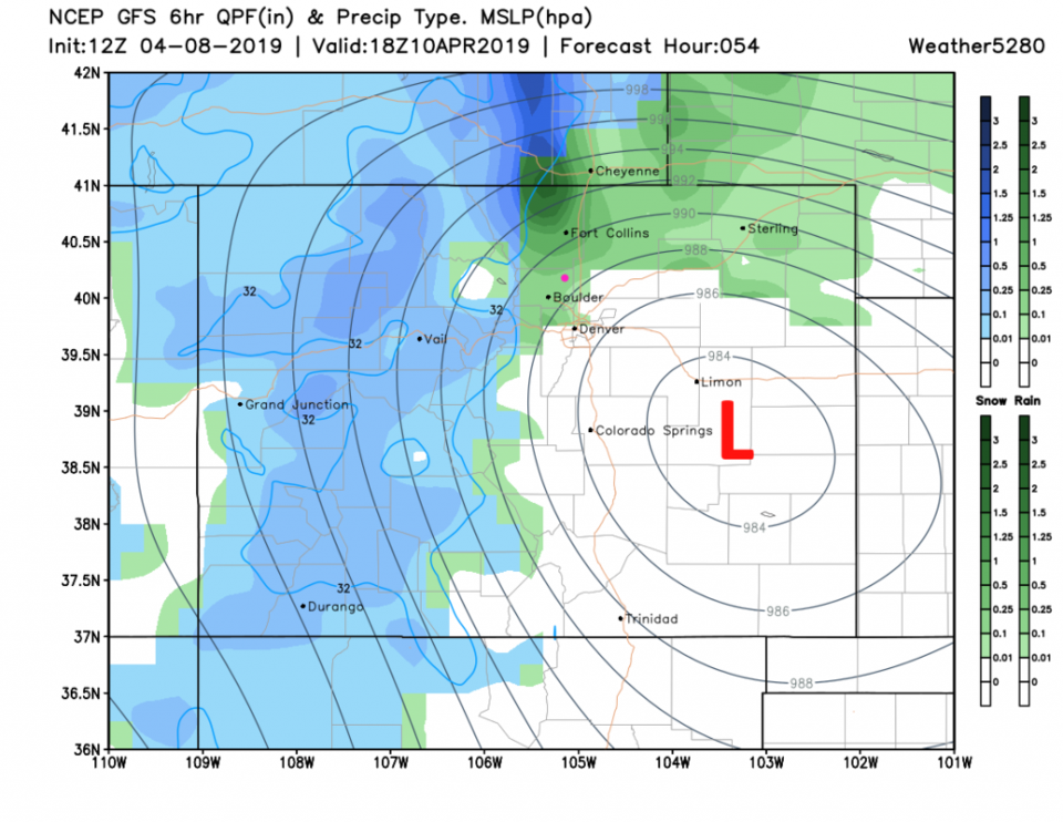
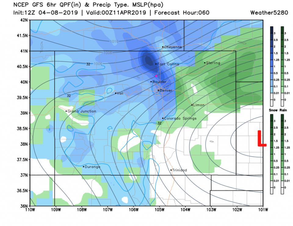
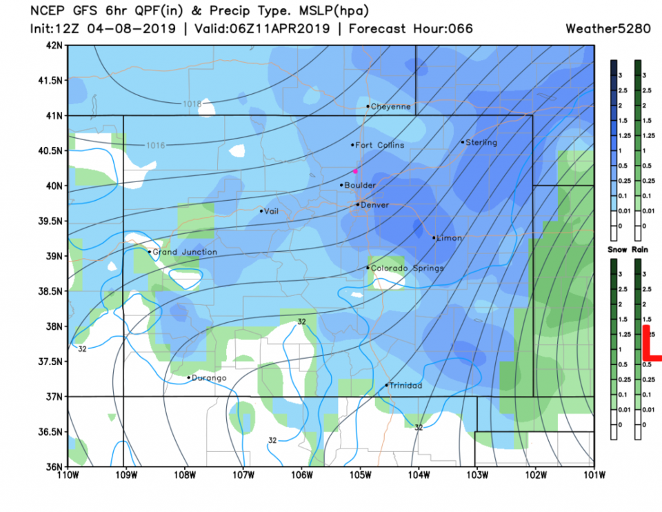
Figure 6 shows the surface low east of Colorado Springs noon Wednesday. By the evening (6 pm, Figure 7) it is near Dodge City, KS with powerful up-slope flow and heavy snow falling on the Front Range and I-25 corridor.
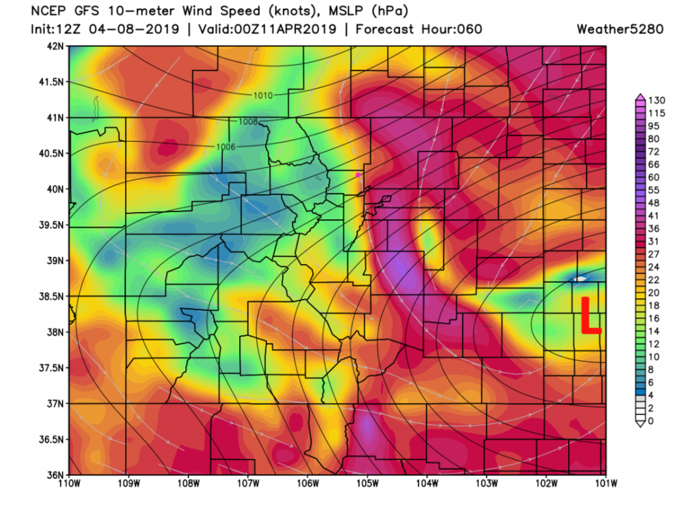
Winds will be roaring out of the northeast at 20-25 mph in town and gusting to 50 mph out on the Plains (Figure 8). Snow continues through midnight into Thursday morning (Figure 9).
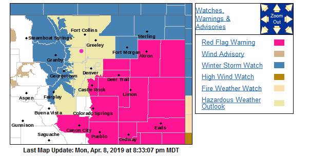
The NWS has already issued a Winter Storm Watch and a Hazardous Weather Outlook for the northern Colorado mountains, the I-25 corridor and the NE Plains to alert everyone of the dramatic changes coming (Figure 10). Some hints of explosive low deepening and winds 90+mph in Lincoln county are showing up in the models - this does make one think of our 'bomb cyclone' thing of recent. Keep an eye on your weather apps for upgrades to the watches and warnings over the next day.
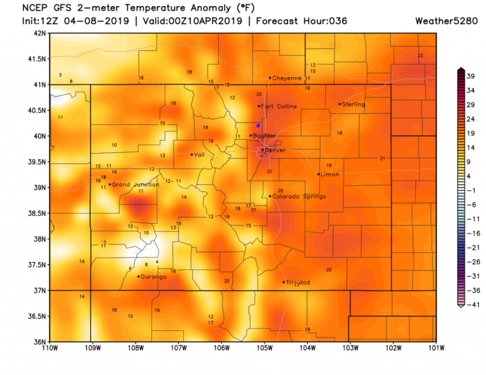
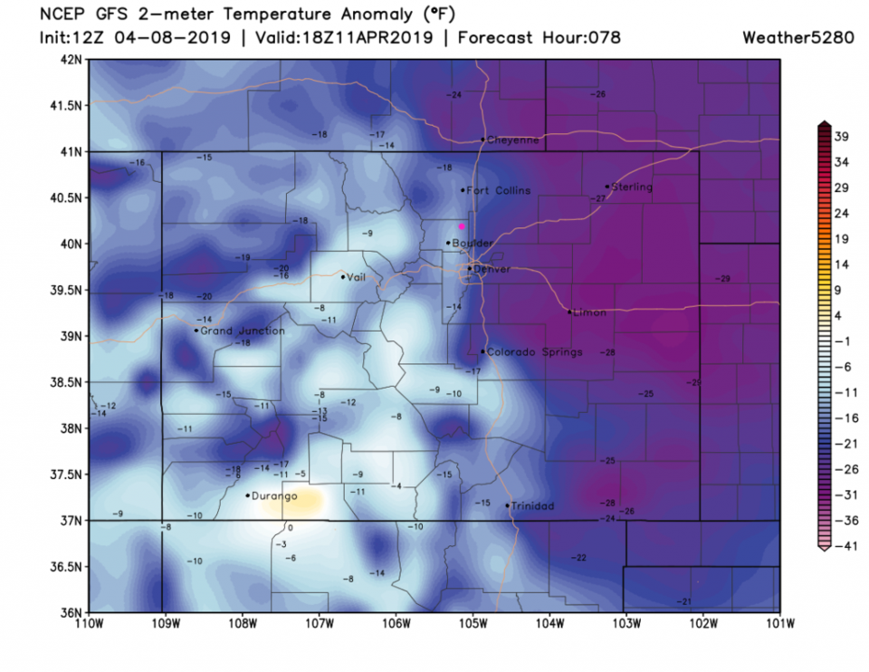
By noon Thursday, we'll see temperatures about 25° F below normal pressing back west to I-25. This is a nearly 50° F drop in temperatures in 48 hours (Figure 11).
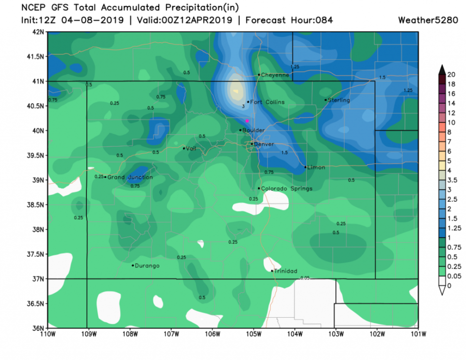
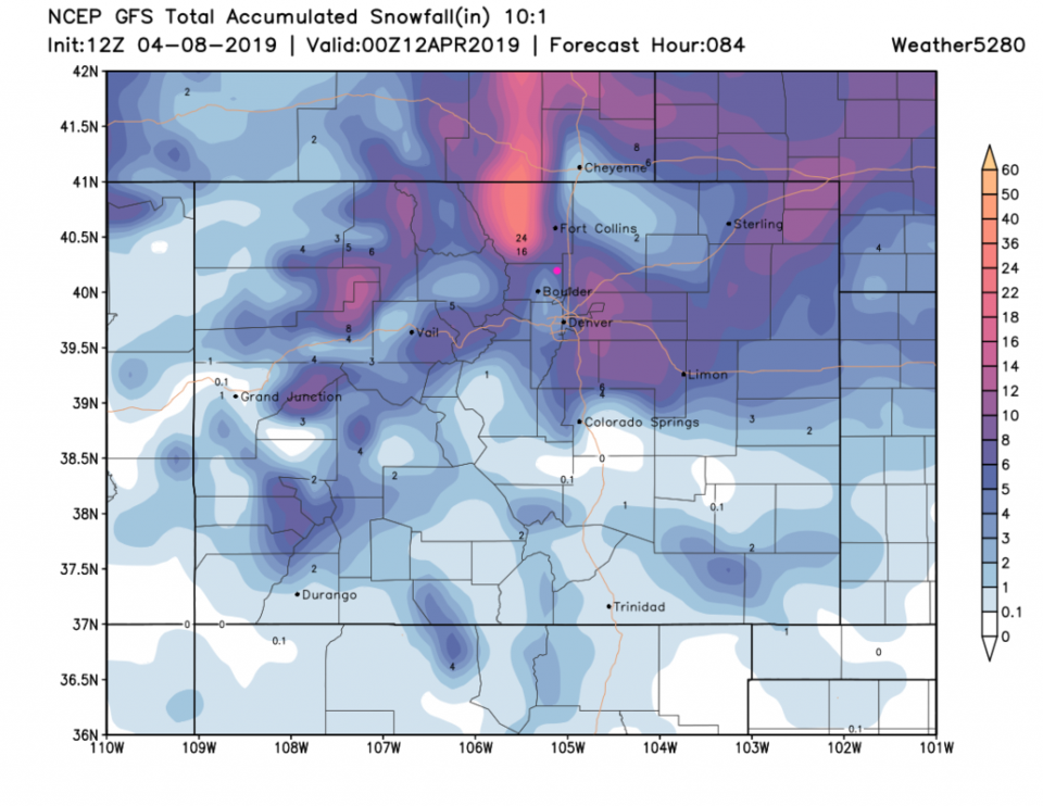
Tomorrow will be the Model Round-Up - but the GFS shows 1.5 inches of rain/water (Figure 12) and 5-6 inches of snow (Figure 13). That seems like a LOT to me, it is probably over done. We'll see what shows up tomorrow. With warm ground temperatures, I don't expect roads to get nasty for hours after the snow begins.
Beyond this storm, we stay fairly cool and showers return now and then. More on those later!