Skip to content

The Next Storm/Next Snow Forecast Discussion from the Cherrywood Observatory – September 30, 2017

This content was originally published by the Longmont Observer and is licensed under a Creative Commons license.

Forecast Discussion:

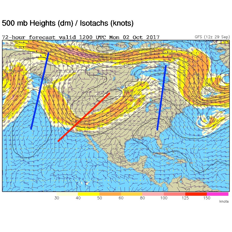
Being on vacation this week, I'm going to keep these just a bit briefer than normal... Figure 1 shows the trough pulling up into the ridge, That ridge has already slided east of the state in this progressive pattern.  This will kick off a chance of rain and higher mountain snows Saturday and Saturday PM.  The big picture is that the jet stream is going to park in the vicinity of our state for many days now. Every ripple that travels downstream can kick off another round of showers across the state.

Figure 1: The Thursday night 500mb upper air map.

In the longer range:

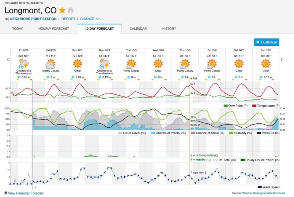
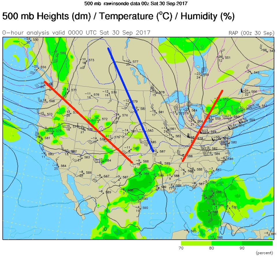
Figure 2, for example, shows another trough moving in on Monday morning, digging cooler air and lift pretty far south. Figure 3 is the 10 day -at a glance- with the greater chance of significant rain for Monday in Longmont. Achance of daily showers - and cool temperatures -  is the story for days to come.  Now I'm off to an out-of-state family wedding!

Figure 2: The GFS forecast 500mb upper air map for Monday morning.

Figure 3: The weatherunderground 10 day graphical forecast.

Current Weather

Cloudy

Cloudy

68°F

UV Index
2 Low
Pressure
29.6 Steady
Visibility
9 miles
Dewpoint
31 °F
Humidity
26%
Wind
NE 6.6 mph
Gust
11.3 mph
Wind Chill
68 °F

Hourly Forecast

Today
4 PM
67°F
Cloudy
Today
5 PM
65°F
Mostly cloudy
Today
6 PM
61°F
Thunderstorms
Today
7 PM
58°F
Thunderstorms
Today
8 PM
55°F
Cloudy
Today
9 PM
52°F
Cloudy
Today
10 PM
50°F
Thunderstorms
Today
11 PM
48°F
Thunderstorms
Tomorrow
12 AM
46°F
Cloudy
Tomorrow
1 AM
46°F
Cloudy
Tomorrow
2 AM
45°F
Cloudy
Tomorrow
3 AM
44°F
Rain

7 Day Forecast

Mostly cloudy w/ t-storms

Friday

69 °F

Variable cloudiness with a couple of thundershowers this afternoon; gusty winds and small hail can accompany any downpour


Thunderstorms

Friday Night

41 °F

Cloudy; a couple of showers and a thunderstorm this evening followed by periods of rain late; gusty winds and small hail can accompany any downpour


Rain

Saturday

44 °F

Chilly with periods of rain and a thunderstorm; travel in the foothills and mountains will be slippery due to snow


Rain and snow

Saturday Night

36 °F

Cloudy with rain, mixed with a little snow late; travel in the foothills and mountains will be slippery due to snow


Mostly cloudy

Sunday

61 °F

Mostly cloudy and warmer


Intermittent clouds

Sunday Night

36 °F

A thunderstorm in spots in the evening; otherwise, partly cloudy


Partly sunny

Monday

71 °F

Partly sunny, pleasant and warmer


Partly cloudy

Monday Night

45 °F

Partly cloudy


Mostly sunny

Tuesday

73 °F

Pleasant with sunshine and patchy clouds


Partly cloudy

Tuesday Night

40 °F

Partly cloudy


Sunrise and Sunset

Sunrise
6:06 AM
Sunset
7:51 PM

Based on AccuWeather data