Skip to content

The Next Storm/Next Snow Forecast Discussion from the Cherrywood Observatory – September 18 2017

This content was originally published by the Longmont Observer and is licensed under a Creative Commons license.

Forecast Discussion:

The lingering moisture and an upper air ripple (short wave) was enough to create thunderstorms that delayed the Denver game, but the Broncos shrugged it off.  Now it dries out and gets warm once again...but not for long.  Figure 1 shows the not-so-large ridge overhead today with the start of the west coast trough that will mean business later this week.  Jose and Maria are the most obvious tropical features over in the Atlantic.

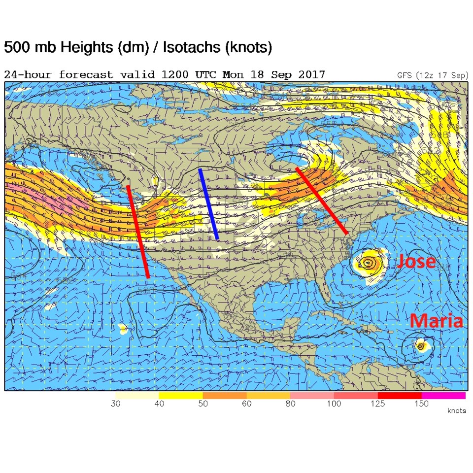
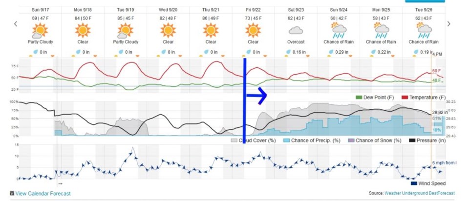
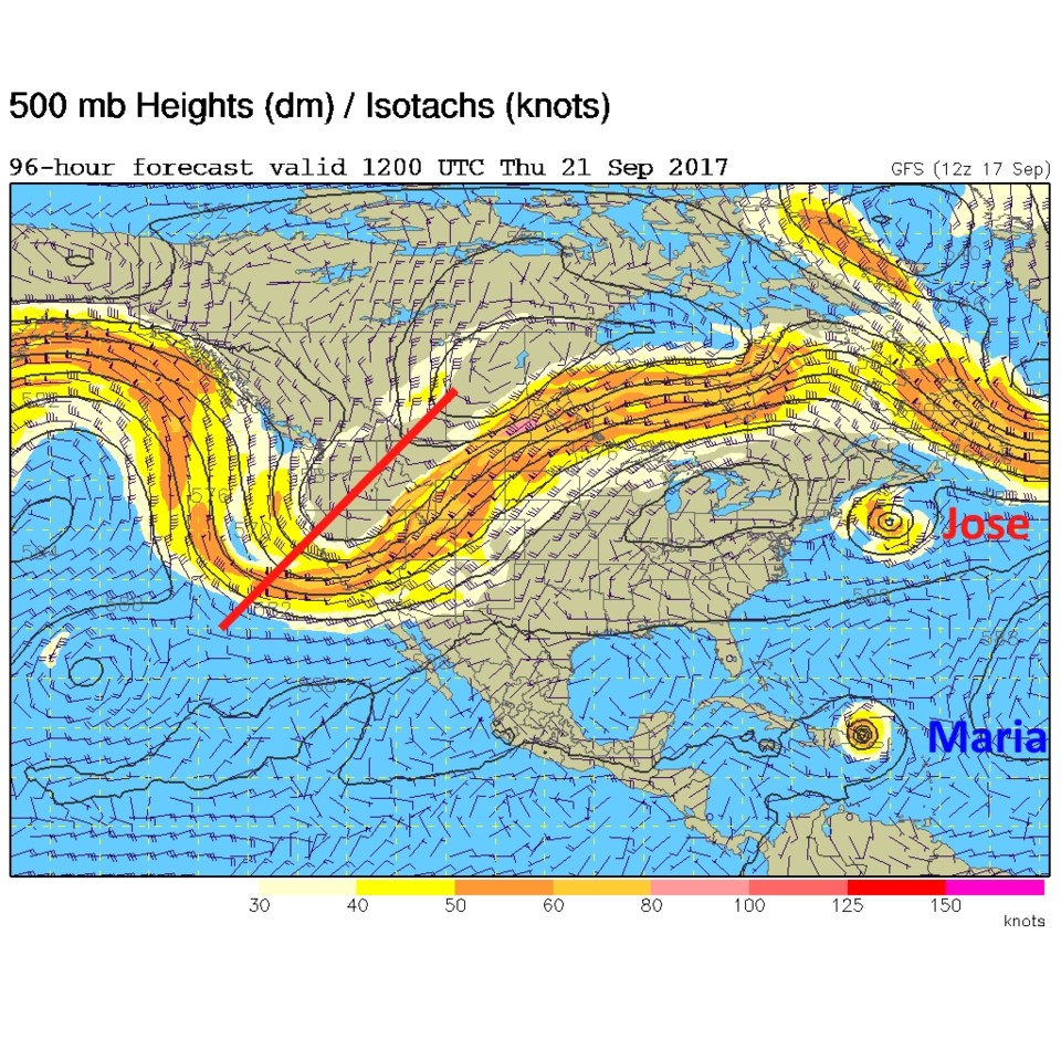
The big news is the strong cold front and pattern change coming at the end of the week.  We linger in the 80's until Friday (as seen in the forecast graph in Figure 2). I marked the earliest arrival of the big front with a bold blue line. After that we get cloudy, cold, and wet. Real Fall weather. Figure 3 is the Thursday morning 500mb map showing the giant trough that will usher in this front.  Jose and Maria have traveled further on their treks at this time.

Figure 1: Monday morning GFS 500mb upper air map, troughs in red, ridge in blue

Figure 2: Weatherunderground 10 day graphical forecast Longmont

Figure 3: Thursday AM GFS 500mb upper air forecast map

In the Longer Range (Tropics Focus):

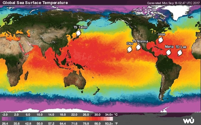
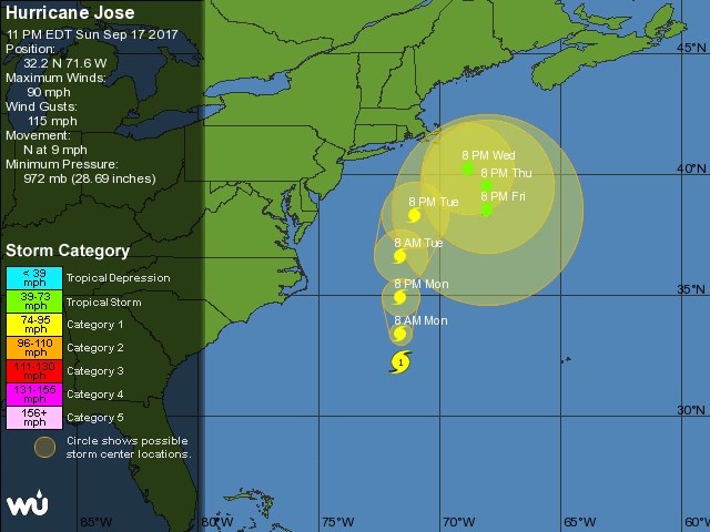
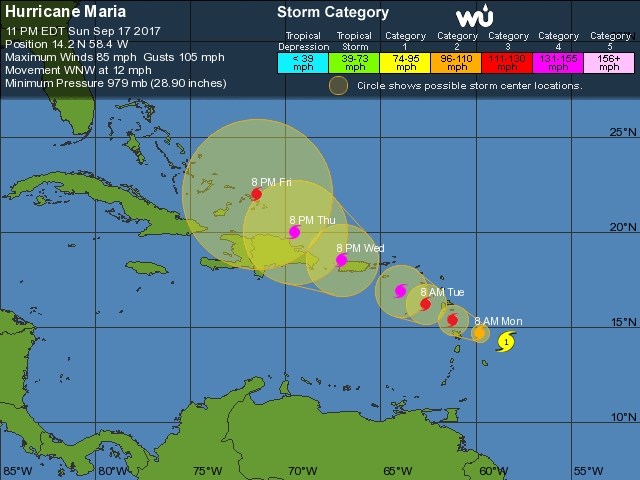
Figure 4 shows a quick view of the five named systems from the Eastern Pacific into the Northern Atlantic. Yes, we still have Jose around. Figure 5 is the 5 day forecast for Jose (currently still packing 115mph sustained winds). Incredibly, after brushing Cape Cod - it may begin to loop back around to the south.  And we need to start really watching Hurricane Maria in Figure 6. It is following a track south of Irma early on, then a bit north like Jose after that.  What will happen beyond day 5?  You'll have to tune in here to find out (or watch any of 100 hurricane Websites and apps <wink>).

Figure 4: The tropics at a glance from weatherunderground

Figure 5: The NHC 5 day forecast for Jose with current conditions.

Figure 6: The NHC 5 day forecast for Maria with current conditions.

Current Weather

Sunny

Sunny

75°F

UV Index
2 Low
Pressure
29.54 Falling
Visibility
8 miles
Dewpoint
45 °F
Humidity
35%
Wind
NE 3.9 mph
Gust
11.2 mph
Wind Chill
75 °F

Hourly Forecast

Today
6 PM
73°F
Cloudy
Today
7 PM
72°F
Cloudy
Today
8 PM
68°F
Cloudy
Today
9 PM
66°F
Cloudy
Today
10 PM
62°F
Mostly cloudy
Today
11 PM
60°F
Intermittent clouds
Tomorrow
12 AM
58°F
Intermittent clouds
Tomorrow
1 AM
56°F
Intermittent clouds
Tomorrow
2 AM
55°F
Mostly cloudy
Tomorrow
3 AM
54°F
Cloudy
Tomorrow
4 AM
52°F
Cloudy
Tomorrow
5 AM
50°F
Cloudy

7 Day Forecast

Intermittent clouds

Sunday

75 °F

Warmer with intervals of clouds and sunshine


Windy

Sunday Night

47 °F

Winds becoming strong; cloudy most of the time


Windy

Monday

56 °F

Winds gusting past 40 mph; cloudy and cooler


Intermittent clouds

Monday Night

42 °F

Partly cloudy


Partly sunny w/ showers

Tuesday

59 °F

A couple of showers in the morning; otherwise, windy and cool with times of clouds and sun


Partly cloudy

Tuesday Night

32 °F

Partly cloudy


Intermittent clouds

Wednesday

58 °F

Cool with times of clouds and sun


Intermittent clouds

Wednesday Night

38 °F

Partly cloudy


Intermittent clouds

Thursday

56 °F

Breezy and cool with sun and clouds


Intermittent clouds

Thursday Night

39 °F

Partly cloudy


Sunrise and Sunset

Sunrise
5:54 AM
Sunset
8:00 PM

Based on AccuWeather data