Skip to content

The Next Storm/Next Snow Forecast Discussion from the Cherrywood Observatory – October 7, 2017

This content was originally published by the Longmont Observer and is licensed under a Creative Commons license.

Forecast Discussion:

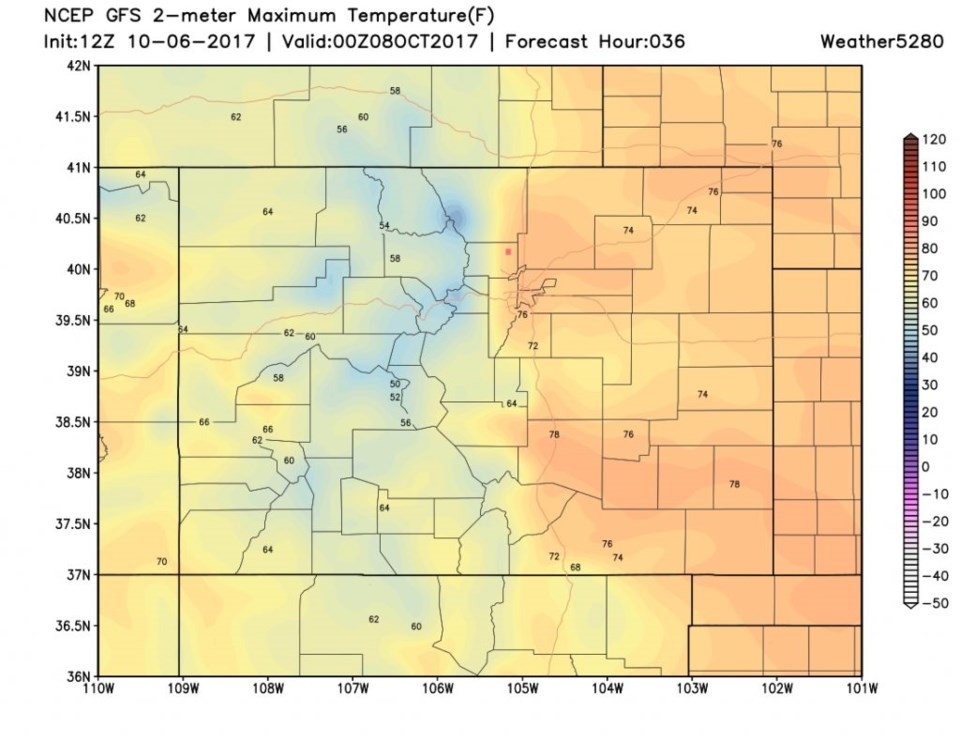
Things are on track for a warm weekend and a cold/wet/snowy Columbus Day. We have gusty down-slope winds buffeting Longmont Friday evening and it may still be breezy at times on Saturday.  Temperatures will be in the mid to upper 70's east of the mountains (Figure 1).

Figure 1: Saturday late afternoon 6 foot above ground level forecast temperatures from the GFS. Longmont is the pink dot.

In the Longer Range:

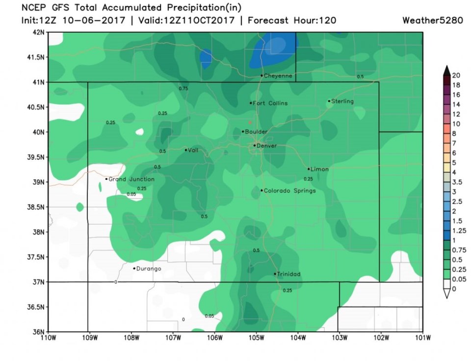
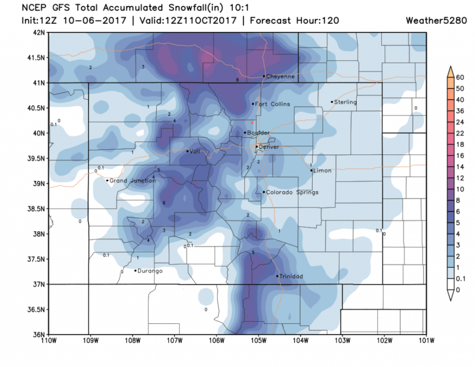
Our next storm is coming more into focus (there is more model agreement at least). The trough is barreling over us on Monday as seen in Figure 2. The GFS total liquid (rain and melted snow) forecast for this storm in Longmont (Figure 3) seems to be in the 0.25 to 0.5" range. The total snowfall (Figure 4) looks to be in the 2-3" range. The National Weather Service is calling for 1-4" along I-25 and 5-10" up in the higher mountains.

The timing seems to have the front hit Longmont around 7pm with rain chances picking up around 9pm and a change over to snow after midnight Sunday.  The snow (or rain/snow mix) should taper off later Monday morning with rapid clearing behind the trough Monday afternoon. Temperatures should be in the mid to lower 20'sF Monday night into Tuesday morning. We'll go back to the 20's F Wednesday morning as well.

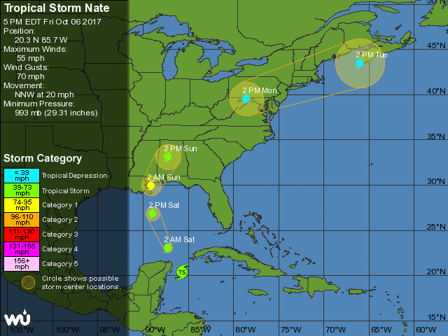
Tropical Storm Nate (in Figure 5) is already about to graze the Yucatan and will be dangerously close to New Orleans - in the present forecast- Saturday night as a Category 1 storm.   More on Nate and our snow as the weekend goes on!

Figure 2: the Monday midday 500mb upper air map model forecast from the GFS. Troughs are red lines, ridges blue lines.

Figure 3: total accumulated precipitation (liquid) between Fri PM and Tuesday PM from the GFS. Longmont is the pink dot.

Figure 4: total accumulated snow (10:1 ratio) between Fri PM and Tuesday PM from the GFS. Longmont is the pink dot.

Figure 5: NHC official 5 day forecast for tropical storm Nate.

Current Weather

Partly cloudy

Partly cloudy

57°F

UV Index
0 Low
Pressure
29.89 Steady
Visibility
8 miles
Dewpoint
35 °F
Humidity
43%
Wind
WNW 3.5 mph
Gust
5.8 mph
Wind Chill
57 °F

Hourly Forecast

Today
1 AM
54°F
Partly cloudy
Today
2 AM
51°F
Partly cloudy
Today
3 AM
48°F
Partly cloudy
Today
4 AM
46°F
Partly cloudy
Today
5 AM
44°F
Partly cloudy
Today
6 AM
42°F
Partly cloudy
Today
7 AM
43°F
Partly sunny
Today
8 AM
46°F
Intermittent clouds
Today
9 AM
49°F
Intermittent clouds
Today
10 AM
51°F
Intermittent clouds
Today
11 AM
54°F
Mostly cloudy
Today
12 PM
57°F
Cloudy

7 Day Forecast

Partly sunny w/ showers

Monday

78 °F

Warmer with a blend of sun and clouds; a couple of showers this afternoon


Partly cloudy

Monday Night

42 °F

Partly cloudy


Mostly cloudy

Tuesday

61 °F

Mostly cloudy and cooler


Partly cloudy w/ showers

Tuesday Night

39 °F

A couple of evening showers; otherwise, partly cloudy


Mostly sunny

Wednesday

76 °F

Pleasant and warmer with sunshine and patchy clouds


Partly cloudy

Wednesday Night

40 °F

Patchy clouds


Mostly cloudy

Thursday

75 °F

Turning cloudy, warm; breezy, a thunderstorm around in the afternoon


Cloudy

Thursday Night

48 °F

Considerable cloudiness with a thundershower in parts of the area


Showers

Friday

71 °F

Mostly cloudy with a couple of showers


Thunderstorms

Friday Night

46 °F

Thundershowers in the evening; cloudy


Sunrise and Sunset

Sunrise
6:11 AM
Sunset
7:47 PM

Based on AccuWeather data