Skip to content

The Next Storm/Next Snow Forecast Discussion from the Cherrywood Observatory – November 13, 2017

This content was originally published by the Longmont Observer and is licensed under a Creative Commons license.

Forecast Discussion:

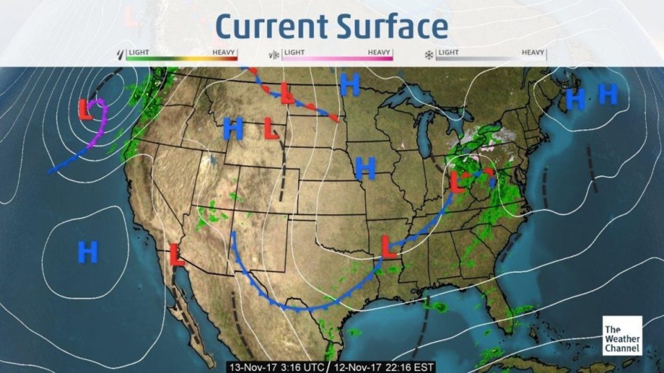
The peaceful weather rolls on.  The dry cool front of Saturday has made it to Mexico

(Figure 1) leaving us to warm up with down slope winds today/Monday.

Figure 1: The surface analysis map from the Weather Channel.

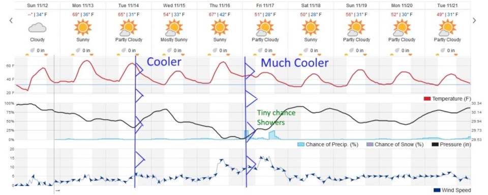
The longer range forecast:

Figure 2 shows the weather trends for the next 10 days... I've drawn in the two cool fronts that are forecasted to come through next- when ripples in the westerly upper level flow (yesterday's forecast discussion) pass over Colorado.  We'll almost hit 70F on Monday! Later on Tuesday another dry cool front drops us 15F, but not much else happens.

The cold front late Thursday into Friday AM will create more snow for the mountains, and a very small chance (at this time) of showers down along I25 - and some better winds.  We do stay more consistently cool after that front though.  Still very quiet around Longmont.

Figure 2: The 10 day forecast graph from wunderground.com.

Current Weather

Light rain

Light rain

49°F

UV Index
0 Low
Pressure
29.77 Rising
Visibility
4 miles
Dewpoint
46 °F
Humidity
90%
Wind
NW 2.9 mph
Gust
6.2 mph
Wind Chill
49 °F

Hourly Forecast

Today
10 PM
48°F
Thunderstorms
Today
11 PM
48°F
Thunderstorms
Tomorrow
12 AM
47°F
Cloudy
Tomorrow
1 AM
47°F
Cloudy
Tomorrow
2 AM
46°F
Cloudy
Tomorrow
3 AM
45°F
Rain
Tomorrow
4 AM
45°F
Cloudy
Tomorrow
5 AM
45°F
Rain
Tomorrow
6 AM
44°F
Rain
Tomorrow
7 AM
44°F
Rain
Tomorrow
8 AM
43°F
Cloudy
Tomorrow
9 AM
42°F
Rain

7 Day Forecast

Mostly cloudy w/ t-storms

Friday

69 °F

Variable cloudiness with a couple of thundershowers this afternoon; gusty winds and small hail can accompany any downpour


Thunderstorms

Friday Night

41 °F

Cloudy; a couple of showers and a thunderstorm this evening followed by periods of rain late; gusty winds and small hail can accompany any downpour


Rain

Saturday

44 °F

Chilly with periods of rain and a thunderstorm; travel in the foothills and mountains will be slippery due to snow


Rain and snow

Saturday Night

36 °F

Cloudy with rain, mixed with a little snow late; travel in the foothills and mountains will be slippery due to snow


Mostly cloudy

Sunday

61 °F

Mostly cloudy and warmer


Intermittent clouds

Sunday Night

36 °F

A thunderstorm in spots in the evening; otherwise, partly cloudy


Partly sunny

Monday

71 °F

Partly sunny, pleasant and warmer


Partly cloudy

Monday Night

45 °F

Partly cloudy


Mostly sunny

Tuesday

73 °F

Pleasant with sunshine and patchy clouds


Partly cloudy

Tuesday Night

40 °F

Partly cloudy


Sunrise and Sunset

Sunrise
6:06 AM
Sunset
7:51 PM

Based on AccuWeather data