This content was originally published by the Longmont Observer and is licensed under a Creative Commons license.
Forecast Discussion:
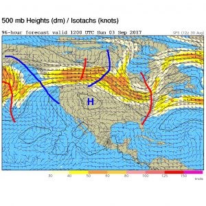
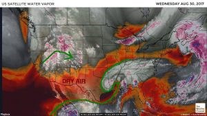
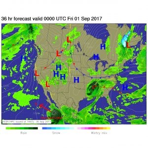
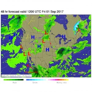
Oh so slowly, Tropical Storm Harvey inches to the northeast away from the Houston area and the Texas Gulf Coast. We are cut off from tropical air as very dry subsident motion (sinking air) dominates Arizona, New Mexico and West Texas. Our next chances of rain are coming from the Pacific as a trough cuts into the big ridge temporarily. Showers are dotting the western mountains Wednesday afternoon (Figure 1). Figure 2 shows the approaching front and the convection firing off primarily in the Rocky Mountains, but there is a chance that afternoon showers will make it down to Longmont Thursday afternoon / evening. The moisture from Harvey still covers most of Louisiana in this forecast map. That is one slow storm. Friday morning the front is through and to our south. The trough (in red in Figure 3) is helping kick Harvey along. Figure 4 shows the moisture still falling in Colorado and Harvey-remains headed to the Ohio Valley.
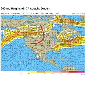
In the longer range: The ridge in the west rapidly rebuilds later Friday into Saturday heating us up again. Figure 5 shows the high pressure center over NW Colorado extending up into Canada. Near record heat is likely Sunday here. The trough picking up the remains of Harvey is on the East coast (some cities may get rained out for some of the Labor Day Weekend by that moisture). This figure also shows that the jet stream way up north with its parade of troughs and ridges.
Labor Day Forecast: Right now, Labor Day looks like a high of 90F, a low of 55F and clear skies (very low chance of rain). Our next trough (allowed in as the ridge pulls out towards the West Coast) may bring cool air and showers in on Tuesday/Wednesday.
The Last of: I like to try to forecast 'last of's' as the years end (and the first of's as the years begin). I think I can safely say that the last 100F day in Longmont is long gone in the rear view mirror. It was 102F on July 19th. Not much of a challenge there. But I'll be keeping my eye out for the last 90F day of 2017 and try to call it as it happens. Then the last 80F day after that, etc. I'll be watching for first snow too, of course. Weather5080.com likes to have a first snow forecast contest, so I'll post that link here when they announce it.