Skip to content

The Next Storm/Next Snow Forecast Discussion from the Cherrywood Observatory - August 30, 2017

This content was originally published by the Longmont Observer and is licensed under a Creative Commons license.

Discussion:

A subtle change is on the way!

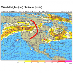
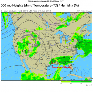
There is still some smoke from the Pacific northwest making the sky a little milky as the airflow is out of the northwest and then southward across the state (Figure 1) . Figure 2 shows the expected future track for the remains of Harvey.  It isn't headed out quickly, but it is beginning to pull away from Houston Tuesday PM.  Figure 3 shows the upper air pattern with our high center now anchored over the Great Basin but the red line shows the change.  That trough will shift the ridge westward away from us, allow a cool front to knock temperatures into the 80's in Longmont Thursday, and help to move Harvey on its way.

Figure 1: The 500mp map from Tuesday PM. The grey line shows the air flow from the northwestern U.S.

Figure 2: The National Hurricane Forecast center forecast for tropical system Harvey.

Figure 3: The 500mb forecast map for Thursday morning showing the trough beginning to cut into the ridge. This will also help move Harvey out of its position.


In a look at the longer range:

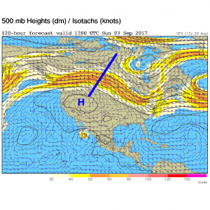
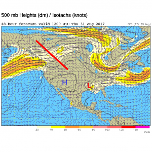
By Friday morning (Figure 4) Harvey has pulled into the lower Mississippi Valley and the cool front has swept down the Front Range. The high center is off the Oregon coast, temporarily. That relief is temporary too.  The high is back (Figure 5) and strong by Sunday morning.  We might see an all time record high temperature on Sunday.  But another cool front may knock us back to the 80's on Monday/Tuesday.

Figure 4: The GFS forecast 500mb map for Friday morning. Red line shows the trough cutting into the high pressure ridge. Harvey remains are the red L.

Figure 5: GFS forecast for Sunday morning - the 500mb pattern again.

Current Weather

Light snow

Light snow

34°F

UV Index
1 Low
Pressure
30.29 Steady
Visibility
2 miles
Dewpoint
30 °F
Humidity
87%
Wind
ENE 2.7 mph
Gust
4.9 mph
Wind Chill
32 °F

Hourly Forecast

Today
12 PM
36°F
Flurries
Today
1 PM
39°F
Flurries
Today
2 PM
40°F
Showers
Today
3 PM
41°F
Cloudy
Today
4 PM
43°F
Cloudy
Today
5 PM
44°F
Cloudy
Today
6 PM
43°F
Cloudy
Today
7 PM
42°F
Cloudy
Today
8 PM
41°F
Cloudy
Today
9 PM
40°F
Cloudy
Today
10 PM
40°F
Cloudy
Today
11 PM
39°F
Cloudy

7 Day Forecast

Rain and snow

Thursday

44 °F

Cloudy and chilly; snow showers this morning, accumulating a coating to an inch followed by a couple of showers this afternoon


Mostly cloudy

Thursday Night

35 °F

Mostly cloudy


Mostly cloudy w/ showers

Friday

48 °F

Chilly with some sun, then turning cloudy; a little rain in the afternoon


Rain and snow

Friday Night

34 °F

Snow at times, accumulating an inch or two; rain mixed in early


Flurries

Saturday

46 °F

A bit of morning snow with little or no accumulation; otherwise, cloudy and chilly; storm total snowfall an inch or two


Intermittent clouds

Saturday Night

31 °F

Partly cloudy


Partly sunny

Sunday

69 °F

Warmer with partial sunshine


Partly cloudy

Sunday Night

44 °F

Partly cloudy


Intermittent clouds

Monday

77 °F

Pleasantly warm with a blend of sun and clouds


Intermittent clouds

Monday Night

39 °F

Increasing clouds


Sunrise and Sunset

Sunrise
6:17 AM
Sunset
7:43 PM

Based on AccuWeather data