Skip to content

Next Storm/Next Snow Forecast Discussion from the Cherrywood Observatory – September 19, 2019

This content was originally published by the Longmont Observer and is licensed under a Creative Commons license.

In Brief:

A cool front Thursday evening and another Friday evening will not only drop our temperatures to very comfortable levels over the weekend but bring back a chance of afternoon showers. We hang out within a few degrees of 80F for the next 10 days (for highs) with a system that might drop significant rain over the region Tuesday and Wednesday next week.

Forecast Discussion:

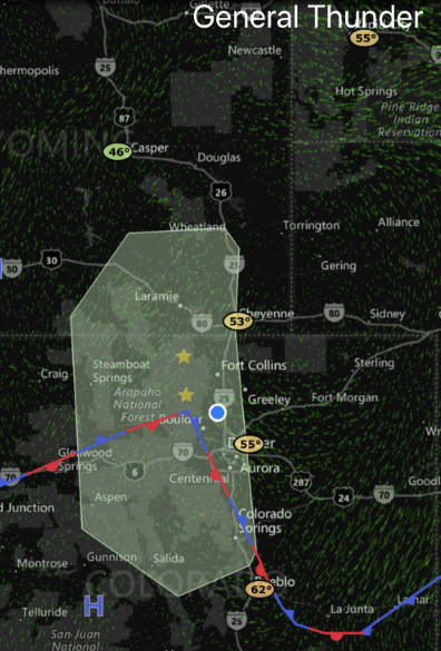
Our normal high for today is about 76F with a normal low of 46F. We are above normal, even with last night's cool down. For Wednesday, there is a chance of a few showers or thundershowers around the Front Range (Figure 1). The Tuesday PM front is draped through the state to our south.

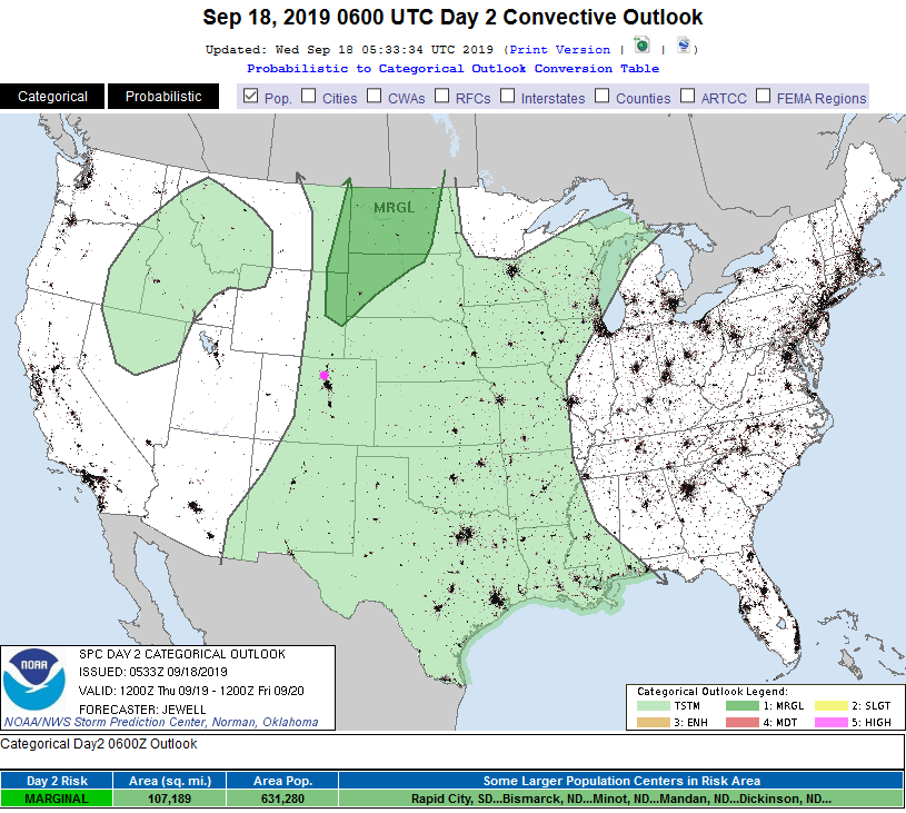
For Thursday - there is still a general chance of showers and thundershowers over the eastern 2/3rds of the state (Figure 2) with our next cool front coming down in the evening after we hit the mid 80'sF again.

The Longer Range Forecast:

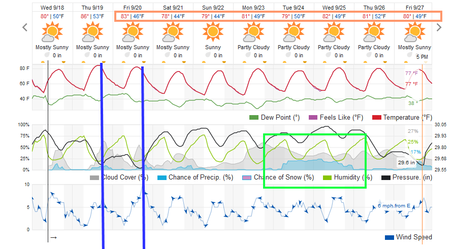
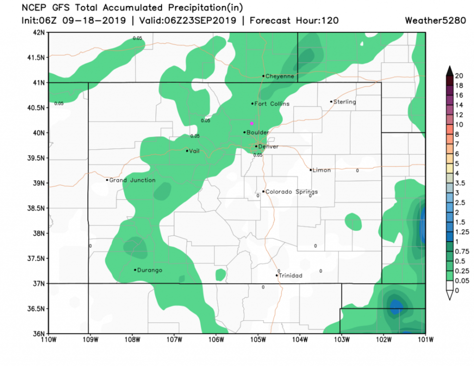
From lower 80'sF on Friday we cool to the mid/upper 70'sF over the weekend. Those mid 40'sF at night will have a snap to them (Figure 3). Over the next 5 days, very little rain will hit the state (Figure 4). Note, temperatures are still a few degrees above normal even on our upcoming coolest day.

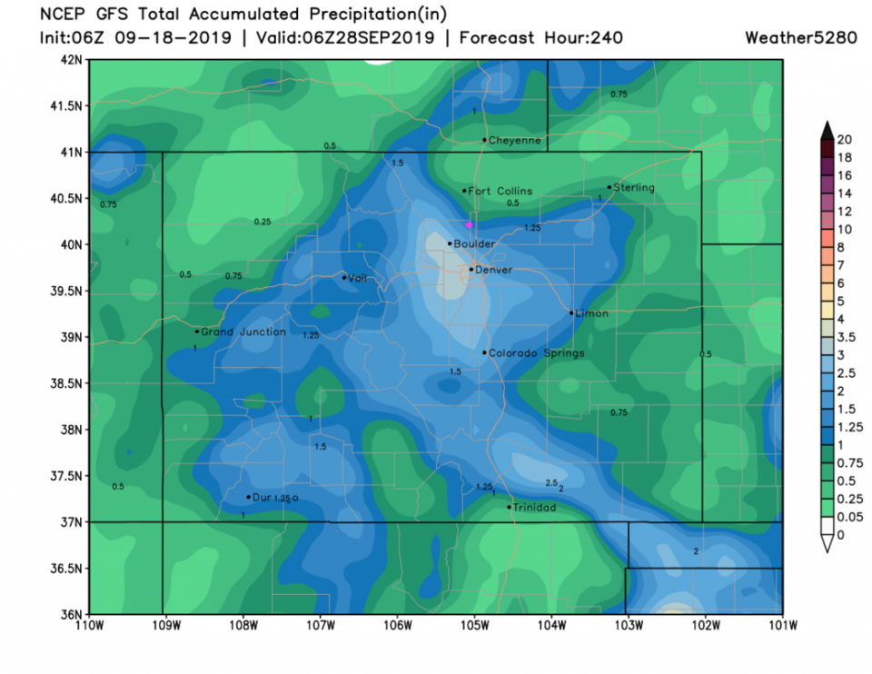
A more significant (and slow moving) storm may roll over the state Tuesday/Wednesday next week and drop real rain over most folks. The GFS paints the foothills above Boulder and Denver with 3 inches of rain over the next 10 days! (Figure 5). The plume of tropical rains visible in yesterday's update down in the four corners area is gone - such is the way with tropical moisture sources.

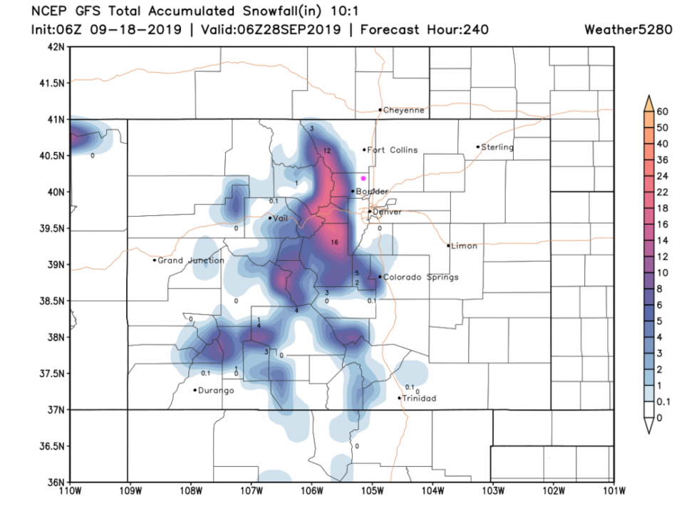
For fun, the next 10 days snowfall puts down over a foot of snow in the higher elevations the middle of next week (Figure 6). We'll see!

Figure 1: The 9am screen capture of the radar and SPC thunderstorm risk map from MyRadar app from iOS.
Figure 2: The severe storm weather forecast for the U.S. from the Storm Predication Center in Norman, OK. Made Wednesday for Wednesday.
Figure 3: the graphical forecast for the next 10 days for Longmont, CO from weatherunderground.com
Figure 4: The forecast rainfall totals for the next 5 days from the GFS and weather5280.com
Figure 5: The forecast rainfall totals for the next 10 days from the GFS and weather5280.com
Figure 6: The forecast snowfall totals for the next 10 days from the GFS and weather5280.com

Current Weather

Cloudy

Cloudy

34°F

UV Index
0 Low
Pressure
30.25 Steady
Visibility
5 miles
Dewpoint
32 °F
Humidity
90%
Wind
ENE 0.5 mph
Gust
2.3 mph
Wind Chill
34 °F

Hourly Forecast

Today
2 AM
34°F
Showers
Today
3 AM
34°F
Cloudy
Today
4 AM
34°F
Mostly cloudy
Today
5 AM
34°F
Mostly cloudy
Today
6 AM
34°F
Cloudy
Today
7 AM
35°F
Cloudy
Today
8 AM
36°F
Intermittent clouds
Today
9 AM
37°F
Intermittent clouds
Today
10 AM
40°F
Intermittent clouds
Today
11 AM
43°F
Intermittent clouds
Today
12 PM
46°F
Intermittent clouds
Today
1 PM
46°F
Intermittent clouds

7 Day Forecast

Rain and snow

Thursday

37 °F

Cloudy and much colder; snow showers this morning, accumulating a coating to an inch followed by brief showers this afternoon


Showers

Thursday Night

34 °F

Mostly cloudy with a couple of brief showers beginning late evening


Mostly cloudy w/ showers

Friday

47 °F

Chilly with some sun, then turning cloudy; a little rain in the afternoon


Rain and snow

Friday Night

33 °F

Periods of snow; rain mixed in early, accumulating an inch or two


Flurries

Saturday

43 °F

A bit of morning snow with little or no accumulation; otherwise, cloudy and chilly; storm total snowfall an inch or two


Intermittent clouds

Saturday Night

31 °F

Partly cloudy


Partly sunny

Sunday

69 °F

Pleasant and warmer with partial sunshine


Partly cloudy

Sunday Night

44 °F

Partly cloudy


Intermittent clouds

Monday

79 °F

Very warm with a blend of sun and clouds


Intermittent clouds

Monday Night

36 °F

Increasing clouds


Sunrise and Sunset

Sunrise
6:17 AM
Sunset
7:43 PM

Based on AccuWeather data