Skip to content

3pm 9/10 Update: Next Storm/Next Snow Forecast Discussion from the Cherrywood Observatory – September 10-11, 2019

This content was originally published by the Longmont Observer and is licensed under a Creative Commons license.

In Brief:

A vigorous short wave trough is passing to the north over the next couple of days . This will give us a small chance of afternoon storms and cool temperatures first to the lower 80'sF then upper 70'sF for the end of the week. We see highs climb back up to the mid and upper 80'sF - somewhat above average - temperatures next week. Dryness will be the overall rule.

3pm 9/10 Update:

The apology tour update: Note, a recent forecast called for quiet weather the rest of the week, but this short wave is looking quite strong and will impact northern Colorado more than appeared a few days ago.

Also, I mentioned that the GFS created a hurricane that hit around New York City later this week. That has vanished from the model, but it continues to create wandering storms around the Atlantic Basin and even in the Gulf over the next 2 weeks. Anything is possible, but long range hurricane forecasting is not a GFS strength. (It is entertaining to watch though <grin>.

Look for an earlier update tomorrow (Wednesday) to catch the details of the severe weather chances in the afternoon.

End 3pm 9/10 Update.

1:30 pm 9/10 Update:

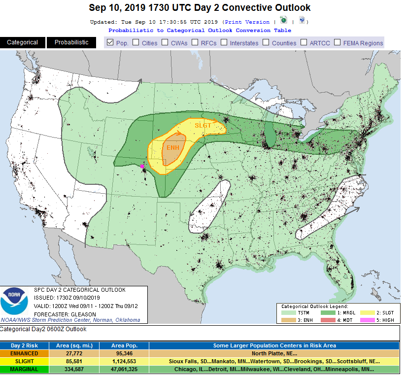
The strong short wave will be doing "it's thing" tomorrow (Wednesday) with very large hail and supercells up in Nebraska. Areas just north of Denver and in the northern mountains of Colorado may see some of this severe thunderstorm activity with large hail as well. The SPC has issued a Marginal Risk for the Front Range with a Slight Risk and Enhanced Risk up in the northeast corner of the state.

Figure 1 update: The severe storm weather forecast for the U.S. from the Storm Predication Center in Norman, OK. Made Tuesday for Wednesday.

End 1:30pm 9/10 Update.

Forecast Discussion:

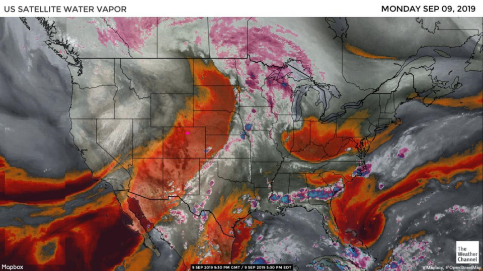
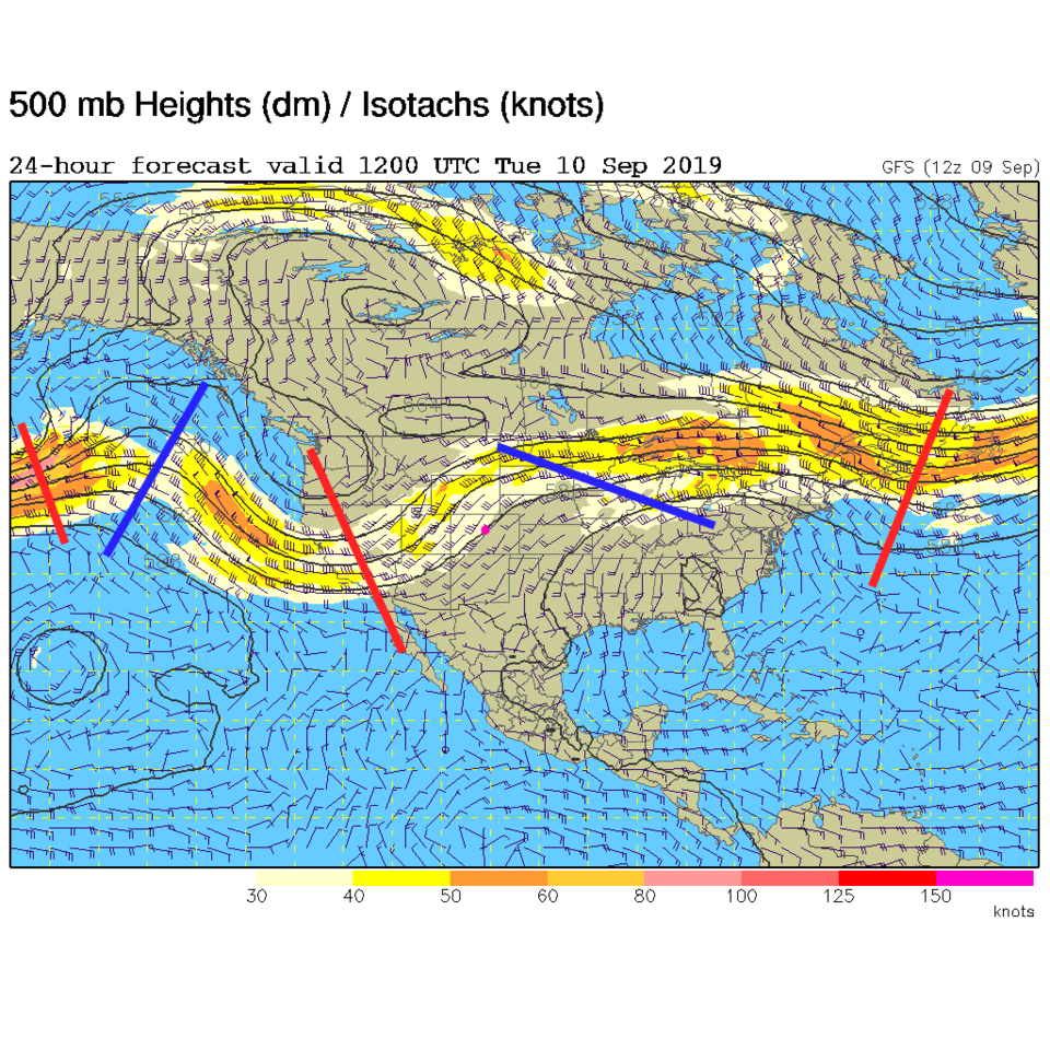
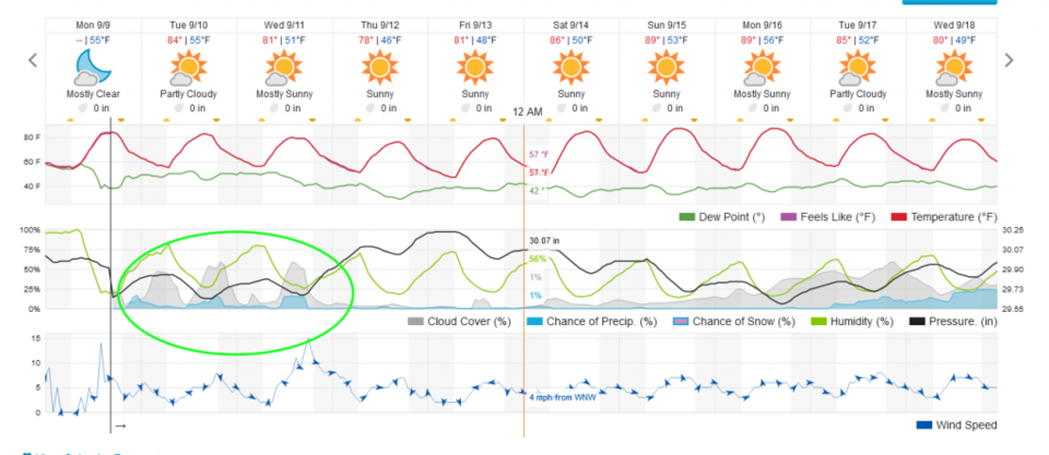
Even though there is some surface moisture around, the bulk of the atmosphere over the state is really dry (red and oranges in Figure 1). The next trough is pretty dry and most of the energy is to the north of the state. As it approaches, we cool down and do see a chance of afternoon showers (Figure 2 and Figure 5).

The Longer Range Forecast:

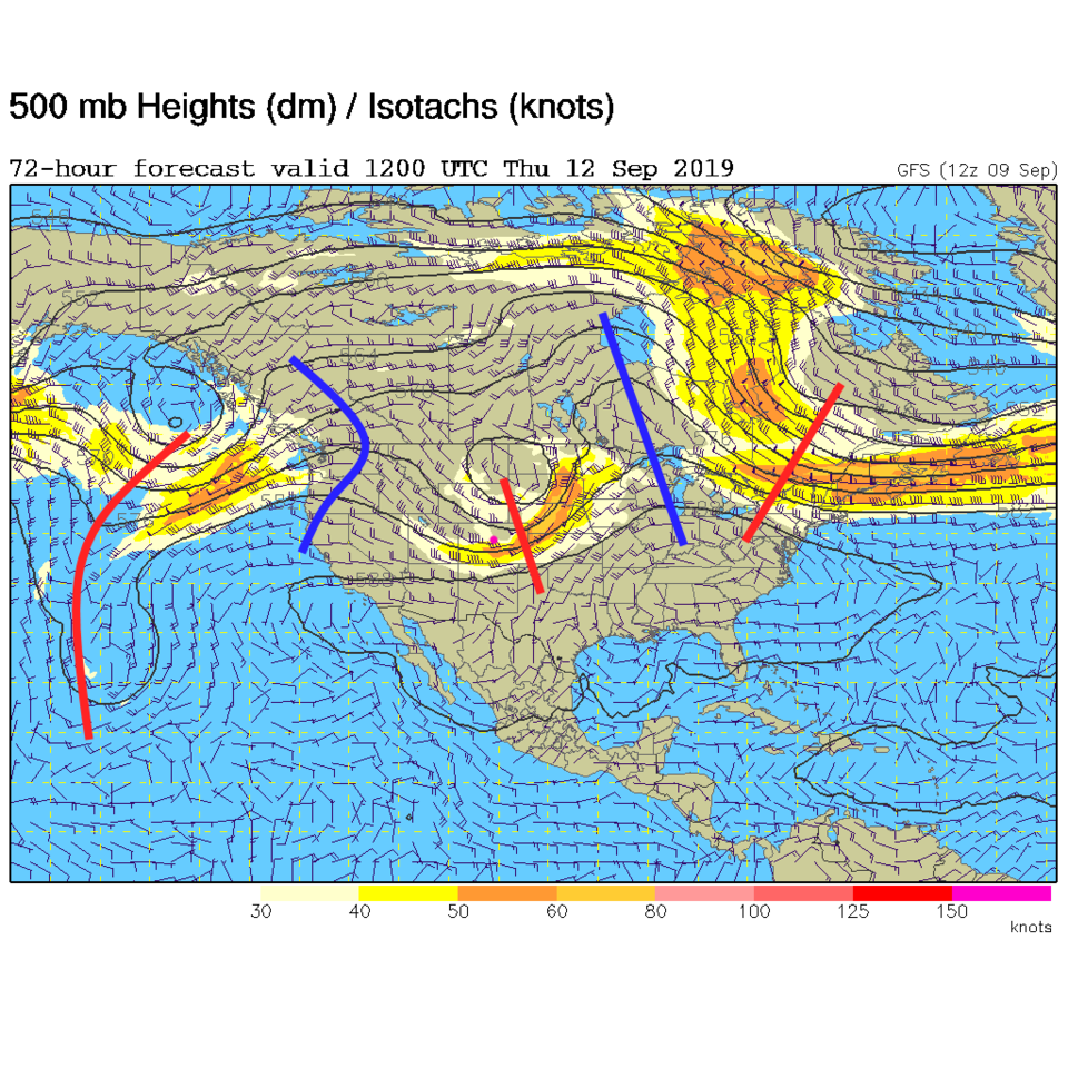
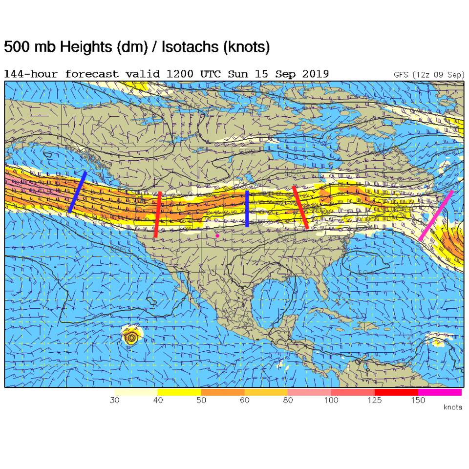
The trough cools us the most on Thursday (Figure 3 and Figure 5) and things dry out (as far as rain chances go). We warm next week as the jet stream really flattens out (becomes zonal Figure 4). We stop seeing 'weather' for a while (Figure 5).

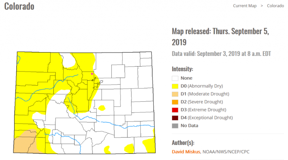
Taking a peak at our drought conditions, there are larger regions of abnormally dry and some regions of moderately dry (near the Four Corners area) forming. This is to be expected in the hot dry summer, but it is the most-moist I've seen the state at the end of summer since I've been watching it here. (Figure 6).

Figure 1: the water vapor satellite image (browns/reds are dry air, whites and light grey is moist air, purple/blue is ice and high cloud tops). From the the Weather Channel from Monday afternoon.
Figure 2: The 500mb forecast upper air analysis for Tuesday AM. Pink dot is Longmont. Red lines are troughs, blue lines are ridges.
Figure 3: The 500mb forecast upper air analysis for Thursday AM. Pink dot is Longmont. Red lines are troughs, blue lines are ridges.
Figure 4: The 500mb forecast upper air analysis for Sunday AM. Pink dot is Longmont. Red lines are troughs, blue lines are ridges.
Figure 5: the graphical forecast for the next 10 days for Longmont, CO from weatherunderground.com
Figure 6: The Colorado drought index map issued Thursday Sept 5 from NOAA/NWS/NCEP and the CPC.

Current Weather

Heavy rain

Heavy rain

50°F

UV Index
0 Low
Pressure
29.75 Rising
Visibility
5 miles
Dewpoint
46 °F
Humidity
85%
Wind
N 3.3 mph
Gust
7.1 mph
Wind Chill
50 °F

Hourly Forecast

Today
9 PM
49°F
Thunderstorms
Today
10 PM
48°F
Thunderstorms
Today
11 PM
48°F
Thunderstorms
Tomorrow
12 AM
47°F
Cloudy
Tomorrow
1 AM
47°F
Cloudy
Tomorrow
2 AM
46°F
Cloudy
Tomorrow
3 AM
45°F
Rain
Tomorrow
4 AM
45°F
Cloudy
Tomorrow
5 AM
45°F
Rain
Tomorrow
6 AM
44°F
Rain
Tomorrow
7 AM
44°F
Rain
Tomorrow
8 AM
44°F
Cloudy

7 Day Forecast

Mostly cloudy w/ t-storms

Friday

69 °F

Variable cloudiness with a couple of thundershowers this afternoon; gusty winds and small hail can accompany any downpour


Thunderstorms

Friday Night

41 °F

Cloudy; a couple of showers and a thunderstorm this evening followed by periods of rain late; gusty winds and small hail can accompany any downpour


Rain

Saturday

44 °F

Chilly with periods of rain and a thunderstorm; travel in the foothills and mountains will be slippery due to snow


Rain and snow

Saturday Night

36 °F

Cloudy with rain, mixed with a little snow late; travel in the foothills and mountains will be slippery due to snow


Mostly cloudy

Sunday

61 °F

Mostly cloudy and warmer


Intermittent clouds

Sunday Night

36 °F

A thunderstorm in spots in the evening; otherwise, partly cloudy


Partly sunny

Monday

71 °F

Partly sunny, pleasant and warmer


Partly cloudy

Monday Night

45 °F

Partly cloudy


Mostly sunny

Tuesday

73 °F

Pleasant with sunshine and patchy clouds


Partly cloudy

Tuesday Night

40 °F

Partly cloudy


Sunrise and Sunset

Sunrise
6:06 AM
Sunset
7:51 PM

Based on AccuWeather data