Skip to content

3:30pm Sun 10/6 Update: Next Storm/Next Snow Forecast Discussion from the Cherrywood Observatory – October 6-7, 2019

This content was originally published by the Longmont Observer and is licensed under a Creative Commons license.

In Brief:

Another dry front sweeps down the Front Range this afternoon/evening cooling us further for Sunday to having a high almost limited to the upper 50'sF. We warm through Tuesday to almost 80'F then a strong cold front blasts in bringing rain and (still looking true) an inch or so of snow Wed/Thur.

3:30pm 10/6 Update:

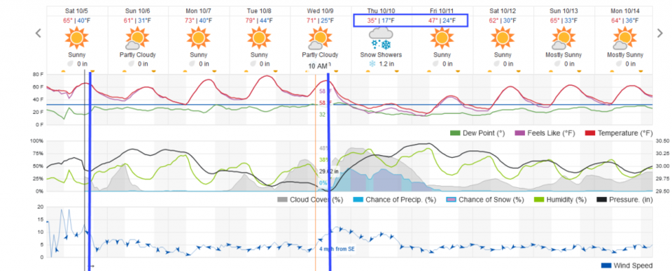
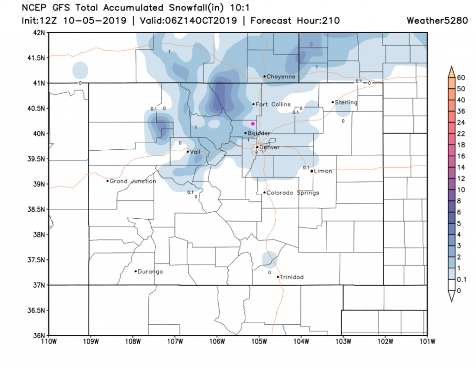
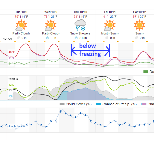
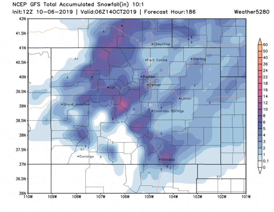
It won't feel like snow when it nearly hits 80F Tuesday and Wednesday (pre-front) - but we should spend almost 30 hours below freezing Thursday AM to Friday midday (Figure 1 update). The weatherunderground.com model gives us 2-3 inches of snow. The GFS seems to give us 3-5 inches (Figure 2 update). Warm ground temperatures will limit snow building to that depth in most places except for the lawn you are probably still watering. (I'm still skepticle that THIS much snow will fall, but note the southwest-northeast streaks in the snow pattern: there will be banding that can drop a lot more snow locally than the region receives as a whole.

(Not shown) the GEM model give us 2.5-3.5 inches of snow. Accuweather gives us a "bit" of snow, but a low Friday AM of 13F. Weatherunderground.com chills us to 16F Friday AM. Be Prepared! (Lion King quote.)

Figure 1 update: a snippet of the graphical forecast for the next 10 days for Longmont, CO from weatherunderground.com
Figure 2 update: The forecast rainfall totals for the next 8 days from the GFS and tropicaltidbits.com for Colorado made early Sunday AM.

End 3:30pm 10/6 Update.

Forecast Discussion:

We are high and dry with cool air in place. A wind shift (a front-like entity) will sweep down the plains this evening - with no rain. We should drop to below freezing briefly Sunday AM (Figure 1 and 2). Dry nice weather is here through Tuesday when we warm almost to 80F.

The Longer Range Forecast:

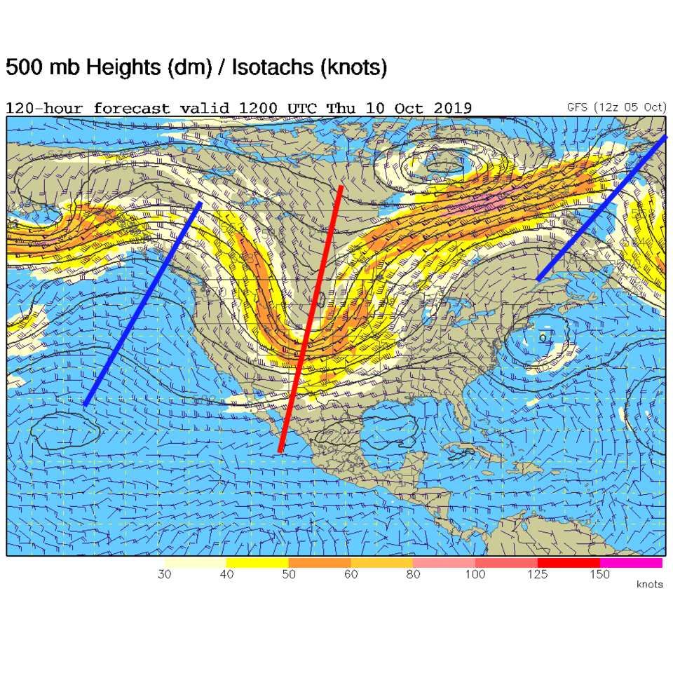
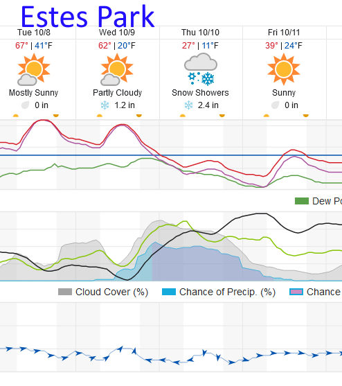
Everyone's eyes are on the big storm coming in Wednesday afternoon (Figure 2). This is still looking to bring our first snow to Longmont for the season. The approaching trough is deep and strong (Figure 3). The weatherunderground model gives us about 1-1.5 inch of snow Wednesday PM through early Friday AM. The GFS has increased snow in the mountains and around Longmont and even out on the Plains giving us between 0.1-1 inch of snow (Figure 4). Figure 5 shows Estes Park getting about 3-4 inches of snow out of this system, at this time. More on this all week!

(Are your sprinklers blown out yet? Lows in the 20'sF Wednesday and Friday mornings and lows in the teens Thursday morning are expected!)

Figure 1: The US current surface map analysis from Saturday afternoon from weatherunderground.com
Figure 2: the graphical forecast for the next 10 days for Longmont, CO from weatherunderground.com
Figure 3: The 500mb forecast upper air analysis for Thursday AM. Pink dot is Longmont. Red lines are troughs, blue lines are ridges.
Figure 4: The forecast rainfall totals for the next 9 days from the GFS and tropicaltidbits.com for Colorado made at midnight Saturday AM.
Figure 5: a snippet of the graphical forecast for the next 10 days for Longmont, CO from weatherunderground.com

Current Weather

Cloudy

Cloudy

32°F

UV Index
0 Low
Pressure
30.35 Steady
Visibility
7 miles
Dewpoint
30 °F
Humidity
94%
Wind
ENE 1.1 mph
Gust
2.2 mph
Wind Chill
32 °F

Hourly Forecast

Today
2 AM
33°F
Cloudy
Today
3 AM
33°F
Cloudy
Today
4 AM
33°F
Snow
Today
5 AM
33°F
Snow
Today
6 AM
33°F
Snow
Today
7 AM
33°F
Cloudy
Today
8 AM
30°F
Flurries
Today
9 AM
32°F
Snow
Today
10 AM
33°F
Cloudy
Today
11 AM
34°F
Cloudy
Today
12 PM
35°F
Cloudy
Today
1 PM
37°F
Cloudy

7 Day Forecast

Rain and snow

Friday

41 °F

Chilly; rain and snow showers in the morning with little or no accumulation followed by rain and drizzle in the afternoon


Snow

Friday Night

30 °F

Periods of wet snow, accumulating 1-3 inches; roads could be slippery


Flurries

Saturday

40 °F

A bit of morning snow with little or no accumulation; otherwise, cloudy and cold; storm total snowfall 1-3 inches


Intermittent clouds

Saturday Night

32 °F

A shower in places this evening; otherwise, partly cloudy


Partly sunny

Sunday

63 °F

Partly sunny and warmer


Mostly clear

Sunday Night

40 °F

Mainly clear


Intermittent clouds

Monday

79 °F

Warmer with intervals of clouds and sun


Partly cloudy

Monday Night

40 °F

Partly cloudy


Mostly cloudy

Tuesday

66 °F

Mostly cloudy and not as warm


Intermittent clouds

Tuesday Night

40 °F

Partly cloudy


Sunrise and Sunset

Sunrise
6:15 AM
Sunset
7:44 PM

Based on AccuWeather data