Skip to content

Next Storm/Next Snow Forecast Discussion from the Cherrywood Observatory – October 16-17, 2019

This content was originally published by the Longmont Observer and is licensed under a Creative Commons license.

In Brief:

Quite warm conditions return with a ridge overhead Wed/Thur and westerly down slope flow/winds. We'll touch 80F again! Then another cold front kicks us back to the 60'sF Fri/Sat and yet another cold front takes us down to the 50'sF for the end of the weekend. The previously mentioned snow chances seem very minimal along I-25 at this time.

Forecast Discussion:

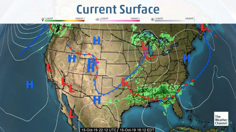
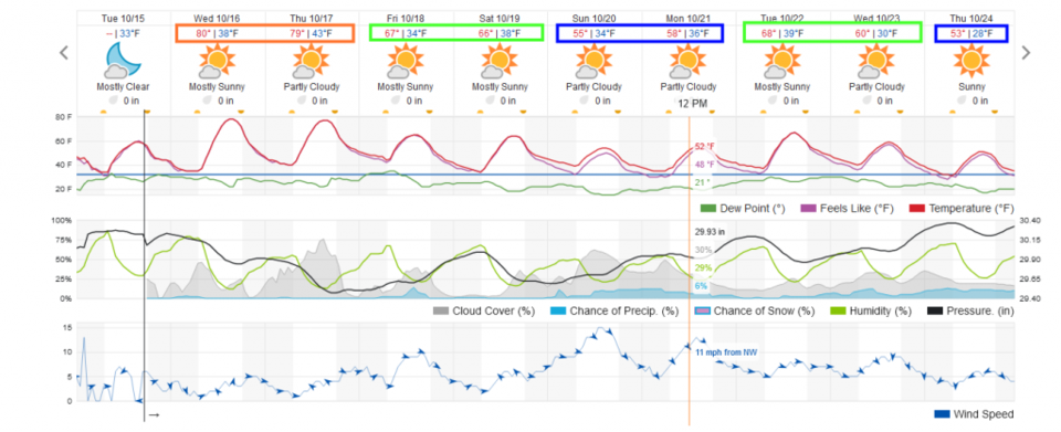
The cold front from Monday is draped down the Front Range Tuesday (Figure 1). It won't remain here long. An approaching upper level ridge will help kick up westerly winds and down slope flow to take us to the 80's for the next couple of days (Figure 5 orange boxes). Very dry conditions (and fire danger) will continue.

The Longer Range Forecast:

Friday and Saturday will be another post-frontal time with things cooled about 15 F from the heat of mid-week (Figure 5 -green boxes). Another cold front takes us another 10 cooler for Sunday and Monday (Figure 5 blue boxes).

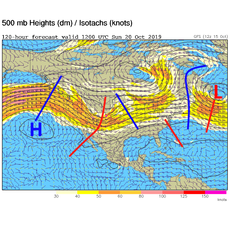
That third cold front will be powered by a fairly strong, but open, wave (Figure 3). With temperatures not THAT cold Sunday/Monday and not THAT much moisture around, it looks like snow will be confined to the mountains and foothills at present. Sorry if you were getting excited.

Figure 1: The current surface analysis map from Thursday afternoon from the weatherchannel.com
Figure 2: The forecast surface map for Thursday AM from NCEP.
Figure 3: The 500mb forecast upper air analysis for Sunday AM. Pink dot is Longmont. Red lines are troughs, blue lines are ridges.
Figure 4: The forecast snowfall totals for the next 6 days from the GFS and weather5280com for Colorado made Saturday morning.
Figure 5: the graphical forecast for the next 10 days for Longmont, CO from weatherunderground.com

Current Weather

Cloudy

Cloudy

56°F

UV Index
0 Low
Pressure
29.68 Rising
Visibility
8 miles
Dewpoint
40 °F
Humidity
56%
Wind
NNW 4.4 mph
Gust
11.1 mph
Wind Chill
56 °F

Hourly Forecast

Today
10 PM
54°F
Cloudy
Today
11 PM
54°F
Cloudy
Tomorrow
12 AM
53°F
Cloudy
Tomorrow
1 AM
52°F
Cloudy
Tomorrow
2 AM
51°F
Cloudy
Tomorrow
3 AM
51°F
Cloudy
Tomorrow
4 AM
50°F
Cloudy
Tomorrow
5 AM
51°F
Cloudy
Tomorrow
6 AM
51°F
Cloudy
Tomorrow
7 AM
52°F
Cloudy
Tomorrow
8 AM
56°F
Cloudy
Tomorrow
9 AM
59°F
Cloudy

7 Day Forecast

Mostly cloudy w/ showers

Thursday

72 °F

Turning cloudy, warm; an afternoon shower or two


Thunderstorms

Thursday Night

50 °F

A thunderstorm in parts of the area this evening; otherwise, considerable cloudiness and mild


Thunderstorms

Friday

70 °F

Mostly cloudy with a couple of thundershowers


Thunderstorms

Friday Night

43 °F

Cloudy with a couple of thundershowers


Rain

Saturday

46 °F

Chilly with periods of rain and a thunderstorm


Rain and snow

Saturday Night

39 °F

Cloudy with rain, mixed with a little snow late


Mostly cloudy

Sunday

59 °F

Mostly cloudy and warmer; a stray afternoon thundershower


Partly cloudy

Sunday Night

36 °F

Partly cloudy


Partly sunny

Monday

71 °F

Partly sunny, pleasant and warmer


Partly cloudy

Monday Night

42 °F

Partly cloudy


Sunrise and Sunset

Sunrise
6:07 AM
Sunset
7:50 PM

Based on AccuWeather data