This content was originally published by the Longmont Observer and is licensed under a Creative Commons license.
In Brief:
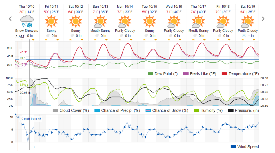
After a small chance of one more dusting of snow this evening, we drop to about 11-14F Friday AM. We warm almost to 50F Friday afternoon and are mostly dry and comfortable 60's-70'sF for the next week.
10:30am Update 10/11:
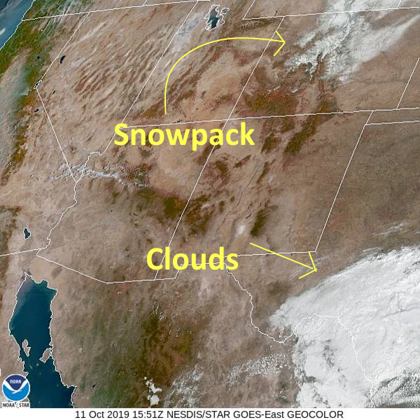
The visible satellite image this morning shows the extent of the snow-pack from our first snow storm (Figure 1 update).
In the NextDoor site, I made the following snowfall prediction - I'll score myself in the final totals below:
Fort Collins: Tr-1", Berthoud: 1/2-2", Longmont: 1-3", Boulder: 2-5", Estes Park: 3-6", western Denver 2-4", eastern Denver: 1/2-2", Palmer Divide communities: 2-5".
Enjoy the nice weather now!
Final totals
- Arvada: 3.8 inches
- Aspen Park: 4.2 inches
- Aurora: 1 inch
- Boulder: 3.3 inches 2-5" (a hit)
- Broomfield: 3.9 inches
- Breckenridge: 6 inches
- Centennial: 4.5 inches
- Denver: 3.3 inches
- Denver International Airport: 1 inch 1/2-2" (a hit)
- Erie: 3 inches
- Estes Park: 6.7 inches 3-6" (pretty much a hit, a bit under)
- Evergreen: 5.5 inches
- Federal Heights: 1.5 inches
- Fort Collins: 2 inches Tr-1" (I busted under the amount)
- Genesee: 4.5 inches
- Golden: 3 inches
- Greeley: 1.4 inches
- Highlands Ranch: 2 inches 2-4" (a hit)
- Kittredge: 3 inches
- Lafayette: 3 inches
- Lakewood: 0.3 inches
- Littleton: 0.5 inches
- Longmont: 2.1 inches 1-3" (A hit, but I saw 3.5" before the afternoon warm-up).
- Loveland: 2 inches
- Mountain View: 4.3 inches
- Nederland: 4 inches
- Niwot: 3.5 inches
- Northglenn: 4.2 inches
- Silverthorne: 0.5 inches
- Steamboat Springs: 6.6 inches
- Strasburg: 2.5 inches
- Vail: 4.5 inches
- Westminster: 2.2 inches
- Windsor: 1.5 inches
End 10:30am Update 10/11.
Forecast Discussion:
The frontal passage yesterday was intense - with wind gusts to the 40mph zone around Longmont and 50+mph in Denver (which also experienced a big dust storm. I was standing outside blowing my sprinklers out and getting chilled to the bone.
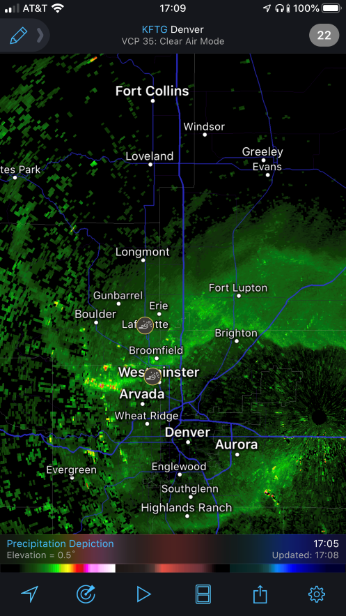
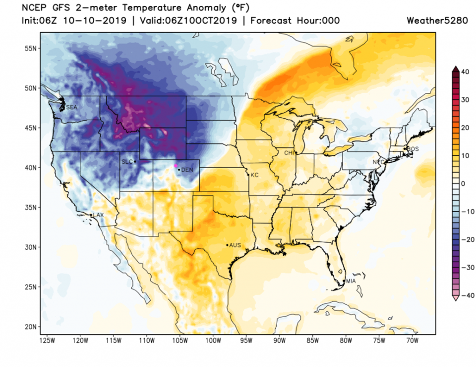
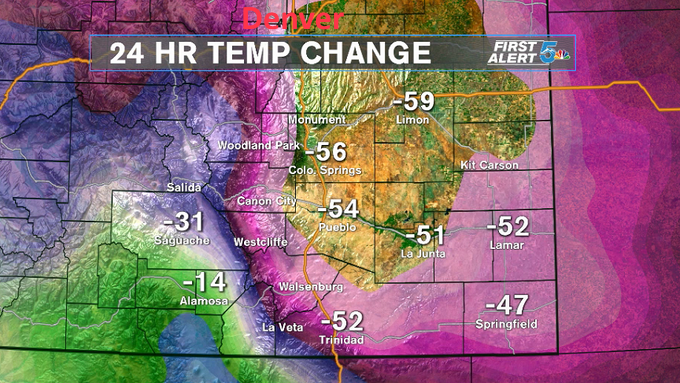
The leading edge of this blast can be seen in Figure 1. Bugs picked up by the wind are concentrated and reflect the radar signal back to the dish. By midnight, the leading edge of the cold air had pushed to the New Mexico border (Figure 2). Channel 5 created a temperature drop graphic for Denver and south showing an almost 60F drop. This is a new record for Colorado in October (Figure 3). If we really drop to about 12F - we'll have about a 70F drop in a day and a half (Figure 4).
We might see one more dusting of snow tonight as another jet streak passes with a bit of moisture (Figure 5).
The Denver Post has listed the following snow totals (and their reporting times). Snow did continue to fall to around noon in most places:
Arvada, Co — 3.8 inches at 10:30 a.m. MDT
Arvada, Co — 3.8 inches at 10:30 a.m. MDT
Black Forest, Co — 2 inches at 12:25 p.m. MDT
Boulder, Co — 3.3 inches at 12 p.m. MDT
Crawford, Co — 1.6 inches at 7:45 a.m. MDT
Crescent Village, Co — 3 inches at 9:50 a.m. MDT
Denver Intl Airport, Co — 1 inch at 12 p.m. MDT
Eagle, Co — 2 inches at 6:55 a.m. MDT
Estes Park, Co — 6.7 inches at 7 a.m. MDT
Evergreen, Co — 4 inches at 10:41 a.m. MDT
Federal Heights, Co — 1.5 inches at 8:30 a.m. MDT
Florissant, Co — 2.7 inches at 11:51 a.m. MDT
Fort Collins, Co — 2 inches at 9:54 a.m. MDT
Fountain, Co — 1.5 inches at 1:33 p.m. MDT
Golden, Co — 3 inches at 9:35 a.m. MDT
Kittredge, Co — 3 inches at 9:01 a.m. MDT
Laporte, Co — 1.6 inches at 7 a.m. MDT
Longmont, Co — 1.5 inches at 7:54 a.m. MDT (I've had 3.5 inches as of 1pm in my yard in NE Colorado.)
Loveland, Co — 2 inches at 7:20 a.m. MDT
Milner, Co — 4.5 inches at 8 a.m. MDT
Montrose, Co — 1.7 inches at 7 a.m. MDT
Mountain View, Co — 4.3 inches at 11:59 a.m. MDT
Nederland, Co — 2 inches at 7:28 a.m. MDT
Niwot, Co — 3.5 inches at 12:55 p.m. MDT
Phippsburg, Co — 1.3 inches at 7 a.m. MDT
Pueblo West, Co — 1.7 inches at 12 p.m. MDT
Steamboat Springs, Co — 6.6 inches at 6 a.m. MDT
Strasburg, Co — 2.5 inches at 11:02 a.m. MDT
Sunshine, Co — 3.5 inches at 10:10 a.m. MDT
Wolcott, Co — 2.9 inches at 7 a.m. MDT
The Longer Range Forecast:
Things get quiet, dry, and comfortable after a cool-ish Friday (Figure 5). There are 70's returning!