Skip to content

Next Storm/Next Snow Forecast Discussion from the Cherrywood Observatory – November 7th, 2018

This content was originally published by the Longmont Observer and is licensed under a Creative Commons license.

Forecast discussion:

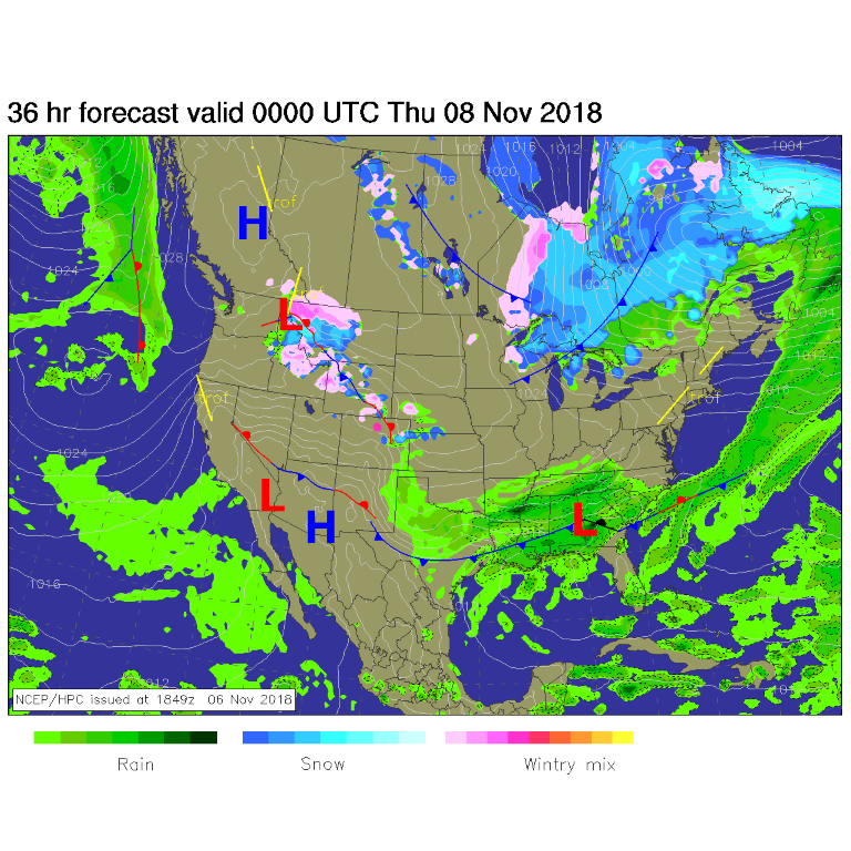
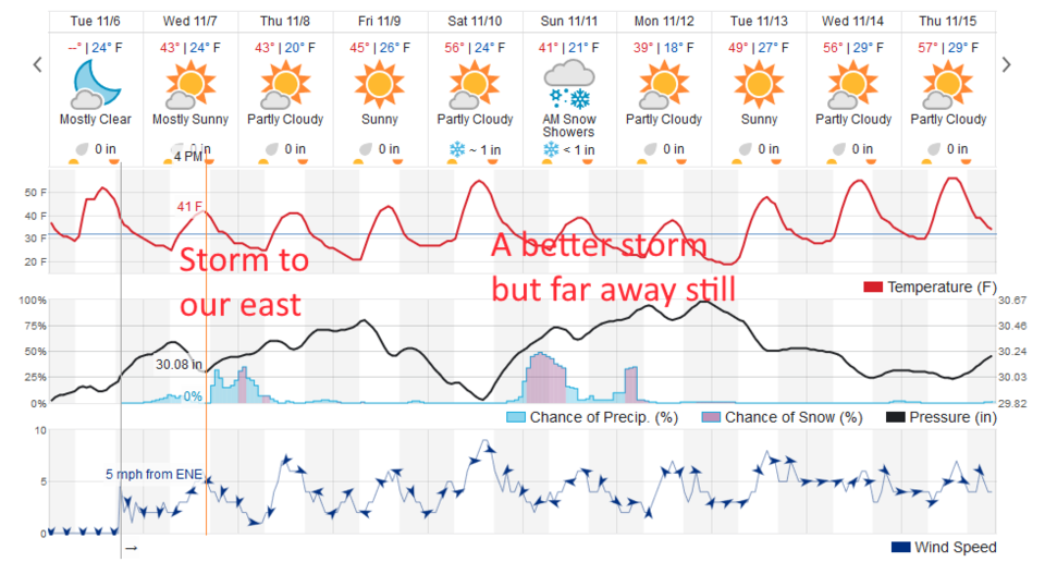
Northwest flow continues as the arctic begins to dump blobs of cold air into the U.S. Midwest. We are on the western edge of this cold-front-train. For most of the rest of the week, we'll be to the north of the frontal zone and highs will remain quite chilly (40's F - Figure 1).

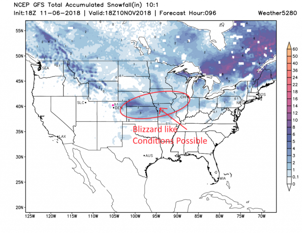
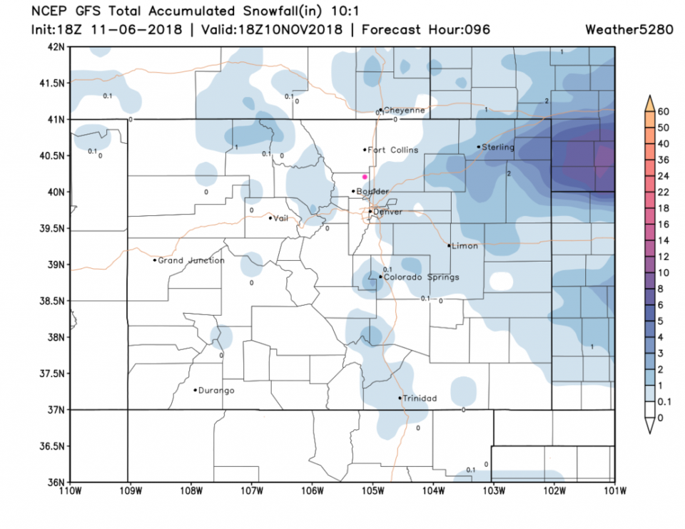
Our next storm pulls past us tonight to Thursday AM (Figure 2). There are chances of snow mixed with the rain, but the significant snows will be out on the plains. Figure 3 shows where blizzard like conditions will occur over the next few days. Figure 4 shows that it is not expected to push this far west at this time. Oh well, snow will come... someday!

Figure 1: The forecast surface map for Wednesday PM. From NCEP.

Figure 2: the next 10 days of the graphical forecast for Longmont, CO from weatherunderground.com

Figure 3: The forecast accumulated snow map from the GFS and weather5280.com for the U.S. for the next 4 days.

Figure 4: The forecast accumulated snow map from the GFS and weather5280.com for Colorado for the next 4 days. Longmont is the pink dot, as always.

The longer range forecast:

That someday may be this weekend. We remain pretty cold overall with a more significant storm on the horizon for Saturday PM and Sunday AM, but we'll handle that after the current storm manifests.

Current Weather

Light rain

Light rain

51°F

UV Index
0 Low
Pressure
29.69 Steady
Visibility
8 miles
Dewpoint
45 °F
Humidity
81%
Wind
ESE 3.8 mph
Gust
8 mph
Wind Chill
51 °F

Hourly Forecast

Today
1 AM
52°F
Cloudy
Today
2 AM
51°F
Cloudy
Today
3 AM
51°F
Cloudy
Today
4 AM
50°F
Cloudy
Today
5 AM
51°F
Cloudy
Today
6 AM
51°F
Cloudy
Today
7 AM
52°F
Cloudy
Today
8 AM
56°F
Cloudy
Today
9 AM
59°F
Cloudy
Today
10 AM
63°F
Mostly cloudy
Today
11 AM
64°F
Mostly cloudy
Today
12 PM
66°F
Mostly cloudy w/ t-storms

7 Day Forecast

Mostly cloudy w/ showers

Thursday

72 °F

Turning cloudy, warm; an afternoon shower or two


Thunderstorms

Thursday Night

50 °F

Considerable cloudiness and mild


Thunderstorms

Friday

70 °F

Mostly cloudy with a couple of thundershowers


Thunderstorms

Friday Night

43 °F

Cloudy with a couple of thundershowers


Rain

Saturday

46 °F

Chilly with periods of rain and a thunderstorm


Rain and snow

Saturday Night

39 °F

Cloudy with rain, mixed with a little snow late


Mostly cloudy

Sunday

59 °F

Mostly cloudy and warmer


Partly cloudy

Sunday Night

36 °F

Partly cloudy


Partly sunny

Monday

71 °F

Partly sunny, pleasant and warmer


Partly cloudy

Monday Night

42 °F

Partly cloudy


Sunrise and Sunset

Sunrise
6:07 AM
Sunset
7:50 PM

Based on AccuWeather data