Skip to content

Next Storm/Next Snow Forecast Discussion from the Cherrywood Observatory – November 28, 2018

This content was originally published by the Longmont Observer and is licensed under a Creative Commons license.

Forecast Discussion:

The march of the pattern continues. Figure 1 shows high pressure still in place over us, but the entire west coast is getting in on the rainfall (and mountain snow) act. Watch for flooding and mud slides in the news, unfortunately. The ridge axis arrives and passes today making today the warmest day of the week and warmest day for a long time (I'm going to try to get my outside Christmas decorations up today!!) - Figure 2. The jet stream (pink arrow in Figure 2) has lifted far to the north of us with the ridge passage.

Figure 1: The forecast surface map for Wednesday PM. From NCEP.

Figure 2: The current 500mb upper air map for Tuesday evening from NCAR/UCAR. The jet stream is the waving red arrow. Troughs are red lines, ridges are blue lines.

The longer range forecast:

Then it is downhill into the end of next week, and beyond. BUT it is not looking as cold or as wet/snowy in Longmont as it did just over the last couple of days of model runs (Figure 3).

The weatherunderground.com model only gives us 1-2 inches through the weekend.

The GFS gives us a coating to an inch through the next 5 days (Figure 4).

The NAM gives us a coating to 1.5 inches through the first half of the weekend (Figure 5).

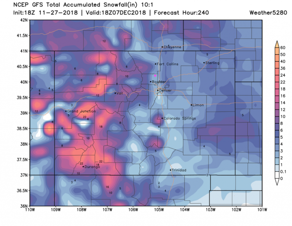
And the super long range, 10 day totals, from the GFS (same as Figure 4) only gives us 2-3 inches at most. That is a big back-off from the models. We'll have to keep watching it, but maybe you can send back your Black Friday/Cyber Monday rider snow mobile??

Figure 3: the graphical forecast for the next 10 days forecast for Longmont, CO from weatherunderground.com

Figure 4: The forecast accumulated snow map from the GFS and weather5280.com for Colorado for the next 5 days, through Sunday Dec 2. Longmont is the pink dot, as always.

Figure 5: The forecast accumulated snow map from the NAM and tropicaltidbits.com for Colorado for the next 4 days, through Saturday morning. Longmont is the pink dot, as always.

Figure 6: The forecast accumulated snow map from the GFS and weather5280.com for Colorado for the next 10 days, through Friday Dec 7. Longmont is the pink dot, as always.

Current Weather

Mostly cloudy

Mostly cloudy

67°F

UV Index
9 Very High
Pressure
29.91 Falling
Visibility
8 miles
Dewpoint
44 °F
Humidity
43%
Wind
ESE 3.8 mph
Gust
8.7 mph
Wind Chill
67 °F

Hourly Forecast

Today
2 PM
67°F
Mostly cloudy
Today
3 PM
68°F
Mostly cloudy
Today
4 PM
69°F
Mostly cloudy
Today
5 PM
68°F
Mostly cloudy
Today
6 PM
66°F
Thunderstorms
Today
7 PM
63°F
Cloudy
Today
8 PM
62°F
Thunderstorms
Today
9 PM
60°F
Cloudy
Today
10 PM
58°F
Cloudy
Today
11 PM
55°F
Cloudy
Tomorrow
12 AM
54°F
Cloudy
Tomorrow
1 AM
52°F
Cloudy

7 Day Forecast

Partly sunny w/ t-storms

Monday

69 °F

Not as warm with clouds and sunshine; a heavy thunderstorm late this afternoon


Thunderstorms

Monday Night

47 °F

Cloudy with a thunderstorm in spots


Thunderstorms

Tuesday

61 °F

Mostly cloudy and cool; a couple of afternoon showers and a thunderstorm


Partly cloudy w/ t-storms

Tuesday Night

36 °F

A thunderstorm in spots in the evening; otherwise, partly cloudy


Partly sunny

Wednesday

72 °F

Partly sunny, pleasant and warmer


Mostly clear

Wednesday Night

40 °F

Mainly clear


Partly sunny

Thursday

82 °F

Warmer with partial sunshine


Mostly cloudy

Thursday Night

44 °F

Mostly cloudy


Showers

Friday

60 °F

Cloudy and cooler with a couple of showers


Intermittent clouds

Friday Night

42 °F

Turning out clear


Sunrise and Sunset

Sunrise
5:40 AM
Sunset
8:15 PM

Based on AccuWeather data