Skip to content

Next Storm/Next Snow Forecast Discussion from the Cherrywood Observatory – November 24, 2018

This content was originally published by the Longmont Observer and is licensed under a Creative Commons license.

Forecast Discussion:

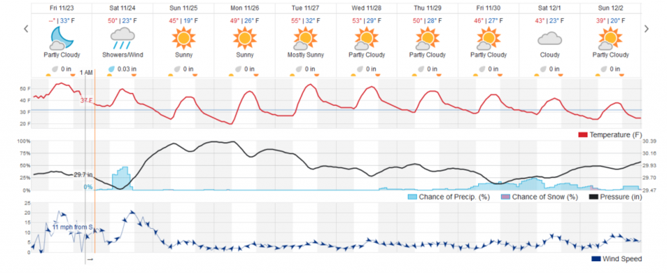
A quick update as I, once again, prepare to travel home from a trip.  Snow is still out of the offing for Longmont today.  We may see a few hundredths of an inch of rain (Figure 1). Things will be cold and gusty (even with some warming down slope flow). Normal highs this time of year are now 49F with a normal low of 31F. We won't be far from normal even with 40'sF Sunday and Monday.

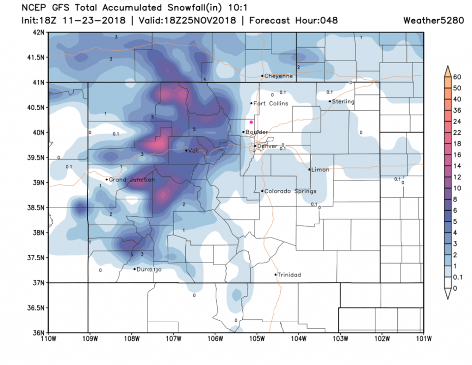
The GFS shows us snow-less today (Figure 2) but the mountains will be getting a foot or more in places.  Don't travel home in from the West without out checking your path.

The longer range forecast:

We warm a bit above normal for the mid week then cool a lot for next weekend.  Snow then?  We will see.  Happy shopping.

Figure 1: the graphical forecast for the next 10 days forecast for Longmont, CO from weatherunderground.com

Figure 2: The forecast accumulated snow map from the GFS and weather5280.com for Colorado for the next 1 days, through Sunday noon. Longmont is the pink dot, as always.

Current Weather

Heavy rain

Heavy rain

50°F

UV Index
0 Low
Pressure
29.75 Rising
Visibility
5 miles
Dewpoint
46 °F
Humidity
85%
Wind
N 3.3 mph
Gust
7.1 mph
Wind Chill
50 °F

Hourly Forecast

Today
9 PM
49°F
Thunderstorms
Today
10 PM
48°F
Thunderstorms
Today
11 PM
48°F
Thunderstorms
Tomorrow
12 AM
47°F
Cloudy
Tomorrow
1 AM
47°F
Cloudy
Tomorrow
2 AM
46°F
Cloudy
Tomorrow
3 AM
45°F
Rain
Tomorrow
4 AM
45°F
Cloudy
Tomorrow
5 AM
45°F
Rain
Tomorrow
6 AM
44°F
Rain
Tomorrow
7 AM
44°F
Rain
Tomorrow
8 AM
44°F
Cloudy

7 Day Forecast

Mostly cloudy w/ t-storms

Friday

69 °F

Variable cloudiness with a couple of thundershowers this afternoon; gusty winds and small hail can accompany any downpour


Thunderstorms

Friday Night

41 °F

Cloudy; a couple of showers and a thunderstorm this evening followed by periods of rain late; gusty winds and small hail can accompany any downpour


Rain

Saturday

44 °F

Chilly with periods of rain and a thunderstorm; travel in the foothills and mountains will be slippery due to snow


Rain and snow

Saturday Night

36 °F

Cloudy with rain, mixed with a little snow late; travel in the foothills and mountains will be slippery due to snow


Mostly cloudy

Sunday

61 °F

Mostly cloudy and warmer


Intermittent clouds

Sunday Night

36 °F

A thunderstorm in spots in the evening; otherwise, partly cloudy


Partly sunny

Monday

71 °F

Partly sunny, pleasant and warmer


Partly cloudy

Monday Night

45 °F

Partly cloudy


Mostly sunny

Tuesday

73 °F

Pleasant with sunshine and patchy clouds


Partly cloudy

Tuesday Night

40 °F

Partly cloudy


Sunrise and Sunset

Sunrise
6:06 AM
Sunset
7:51 PM

Based on AccuWeather data