Skip to content

10pm UPDATE: Next Storm/Next Snow Forecast Discussion from the Cherrywood Observatory – November 18, 2018

This content was originally published by the Longmont Observer and is licensed under a Creative Commons license.

The Forecast Discussion and longer range forecast:

10pm Update:

The storm started out with cold rain overnight - then a period of freezing rain/drizzle (my airplane was ice coated on the north side at our 10am takeoff. Then there was real snow.

Unlike the last storm (that overproduced on most forecasts) - this one spent a lot of its water content in that earlier rain and freezing rain.  Snowfall totals were at the low end.

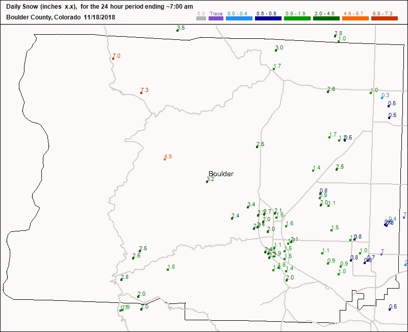
Longmont received about 1/3rd to 1 inch of snow 7am yesterday to 7am today (Figure 1 update).

Figure 1 update: The CoCoRaHS snowfall total 7am Saturday to 7am Sunday. for Boulder, CO.

End 10pm Update.

The drizzle, ice, and snow continues as I write, so I'll update later day with storm reports.

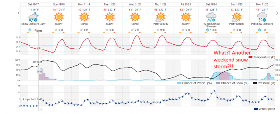
This fades out by the time this post goes live (and I'm traveling for Thanksgiving currently). We are mild and dry UNTIL next weekend when another snow storm has appeared.  It is always best to look at the NEXT storm after the NEXT storm is done.

Enjoy this nice work week, at least!

Figure 1: the piece of the next 10 days of the graphical forecast for Longmont, CO from weatherunderground.com

Current Weather

Mostly sunny

Mostly sunny

65°F

UV Index
6 High
Pressure
29.6 Steady
Visibility
7 miles
Dewpoint
34 °F
Humidity
31%
Wind
WNW 5.1 mph
Gust
11.6 mph
Wind Chill
65 °F

Hourly Forecast

Today
11 AM
66°F
Partly sunny
Today
12 PM
67°F
Intermittent clouds
Today
1 PM
68°F
Intermittent clouds
Today
2 PM
69°F
Intermittent clouds
Today
3 PM
70°F
Intermittent clouds
Today
4 PM
68°F
Intermittent clouds
Today
5 PM
66°F
Mostly cloudy
Today
6 PM
61°F
Thunderstorms
Today
7 PM
58°F
Thunderstorms
Today
8 PM
56°F
Cloudy
Today
9 PM
53°F
Cloudy
Today
10 PM
51°F
Thunderstorms

7 Day Forecast

Mostly cloudy w/ t-storms

Friday

70 °F

Some sun, then increasing clouds with a couple of thundershowers this afternoon; gusty winds and small hail can accompany any downpour


Thunderstorms

Friday Night

44 °F

Cloudy; a couple of showers and a thunderstorm this evening followed by periods of rain late; gusty winds and small hail can accompany any downpour


Rain

Saturday

47 °F

Chilly with periods of rain and a thunderstorm; travel in the foothills and mountains will be slippery due to snow


Rain and snow

Saturday Night

36 °F

Cloudy with rain, mixed with a little snow late; travel in the foothills and mountains will be slippery due to snow


Mostly cloudy

Sunday

61 °F

Mostly cloudy and warmer


Intermittent clouds

Sunday Night

36 °F

A thunderstorm in spots in the evening; otherwise, partly cloudy


Partly sunny

Monday

71 °F

Partly sunny, pleasant and warmer


Partly cloudy

Monday Night

45 °F

Partly cloudy


Mostly sunny

Tuesday

73 °F

Pleasant with sunshine and patchy clouds


Partly cloudy

Tuesday Night

43 °F

Partly cloudy


Sunrise and Sunset

Sunrise
6:06 AM
Sunset
7:51 PM

Based on AccuWeather data