Skip to content

11/18 8am Update: Next Storm/Next Snow Forecast Discussion from the Cherrywood Observatory – November 18-19, 2019

This content was originally published by the Longmont Observer and is licensed under a Creative Commons license.

In Brief:

We start the week very mild (above average about 10-12F) until fronts hit Tuesday night and Wednesday morning. Temperatures drop and snow will fall from Wednesday afternoon through most of Thursday into Friday early morning. Still, only a few inches if snow is expected to build up. Another storm is showing up on the horizon middle of next week.

11/18 8am update:

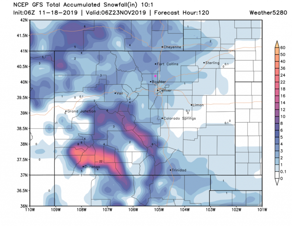
This is a quick check in with the GFS concerning the Wednesday/Thursday storm. The trend is away from as much snow in northern Colorado and the NE Plains with the best snow building up in the SW mountains of the state (Figure 1 update). We are still sitting in the, roughly 1-2, locally 3 inch area in our snowfall expectation. It will start as rain before temperatures drop low enough for snow. Thursday will be quite chilly but lows at night will only be in the 20'sF - this is pretty normal for this time of year.

Figure 1 update: The forecast snowfall totals for the next 5 days from the GFS and weather5280com for Colorado made Monday morning.

End 11/18 8am update.

Forecast Discussion:

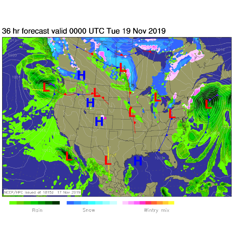
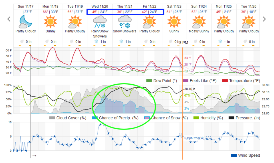
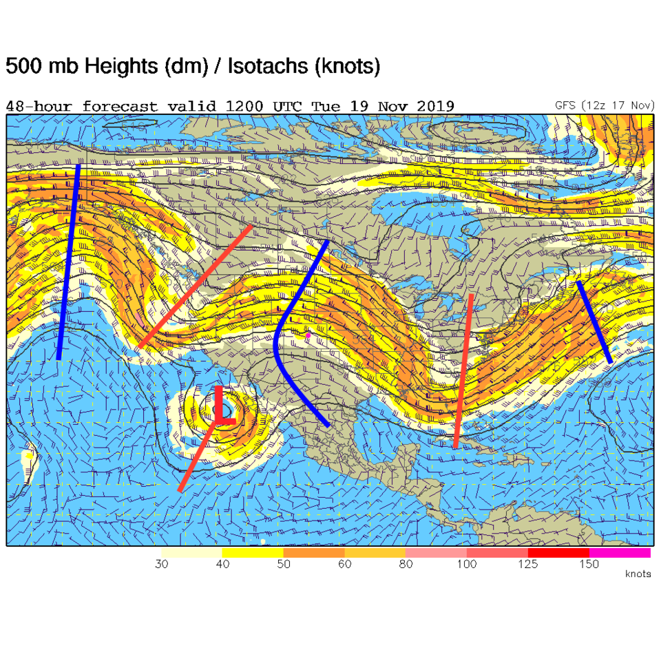
We are high and dry except for some showers in the northern mountains (Figure 1). With a healthy ridge overhead (blue line in Figure 3) we are sitting about 10-12F above average Monday and Tuesday (Figure 2). It is a boring-weather start to the week.

The Longer Range Forecast:

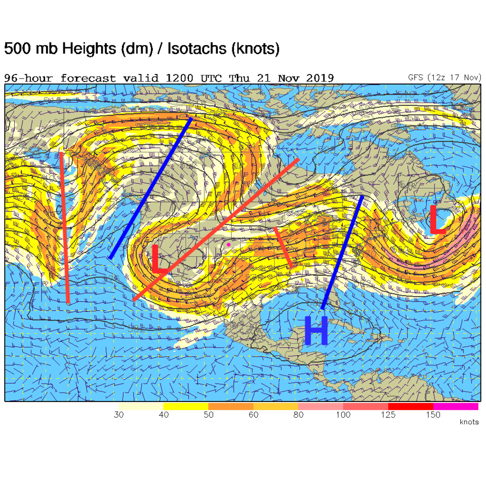
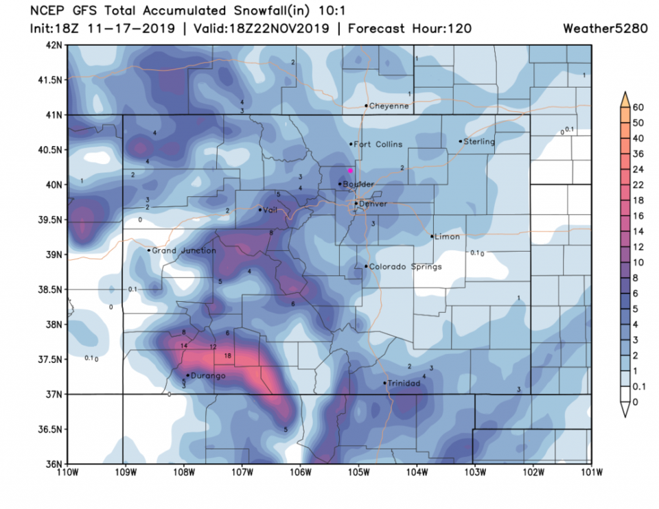
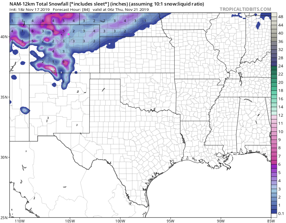
But fun is coming. There is a west coast trough approaching in Figure 3 with a cut-off low pulling moisture into the desert southwest visible to our distant southwest. By Wednesday and Thursday that cutoff merges with the trough and the whole thing slows down giving us cold air, up slope flow, and moisture (Figure 4). Weather underground shows about 2 inches of snow falling from Wednesday evening (after some rain) through early Friday morning. The GFS gives us about 2-3 inches over this storm (Figure 5) while the NAM gives us about 2-4 inches (Figure 6).

Figure 1: The forecast surface map for Monday evening from NCEP.
Figure 2: the graphical forecast for the next 10 days for Longmont, CO from weatherunderground.com
Figure 3: The 500mb forecast upper air analysis for Tuesday morning. Pink dot is Longmont. Red lines are troughs, blue lines are ridges.
Figure 4: The 500mb forecast upper air analysis for Tuesday morning. Pink dot is Longmont. Red lines are troughs, blue lines are ridges.
Figure 5: The forecast snowfall totals for the next 5 days from the GFS and weather5280com for Colorado made Thursday morning.
Figure 6: The forecast snowfall totals through Thursday early morning from the NAM and tropicaltidbits.com for Colorado.

Current Weather

Rain

Rain

49°F

UV Index
0 Low
Pressure
29.72 Rising
Visibility
7 miles
Dewpoint
44 °F
Humidity
83%
Wind
NE 4.6 mph
Gust
8.2 mph
Wind Chill
47 °F

Hourly Forecast

Today
8 PM
56°F
Thunderstorms
Today
9 PM
53°F
Thunderstorms
Today
10 PM
50°F
Thunderstorms
Today
11 PM
48°F
Thunderstorms
Tomorrow
12 AM
46°F
Cloudy
Tomorrow
1 AM
46°F
Cloudy
Tomorrow
2 AM
45°F
Cloudy
Tomorrow
3 AM
44°F
Rain
Tomorrow
4 AM
44°F
Cloudy
Tomorrow
5 AM
44°F
Rain
Tomorrow
6 AM
44°F
Rain
Tomorrow
7 AM
44°F
Rain

7 Day Forecast

Mostly cloudy w/ t-storms

Friday

69 °F

Variable cloudiness with a couple of thundershowers this afternoon; gusty winds and small hail can accompany any downpour


Thunderstorms

Friday Night

41 °F

Cloudy; a couple of showers and a thunderstorm this evening followed by periods of rain late; gusty winds and small hail can accompany any downpour


Rain

Saturday

44 °F

Chilly with periods of rain and a thunderstorm; travel in the foothills and mountains will be slippery due to snow


Rain and snow

Saturday Night

36 °F

Cloudy with rain, mixed with a little snow late; travel in the foothills and mountains will be slippery due to snow


Mostly cloudy

Sunday

61 °F

Mostly cloudy and warmer


Intermittent clouds

Sunday Night

36 °F

A thunderstorm in spots in the evening; otherwise, partly cloudy


Partly sunny

Monday

71 °F

Partly sunny, pleasant and warmer


Partly cloudy

Monday Night

45 °F

Partly cloudy


Mostly sunny

Tuesday

73 °F

Pleasant with sunshine and patchy clouds


Partly cloudy

Tuesday Night

40 °F

Partly cloudy


Sunrise and Sunset

Sunrise
6:06 AM
Sunset
7:51 PM

Based on AccuWeather data