Skip to content

Next Storm/Next Snow Forecast Discussion from the Cherrywood Observatory – November 16, 2018

This content was originally published by the Longmont Observer and is licensed under a Creative Commons license.

The longer range forecast:

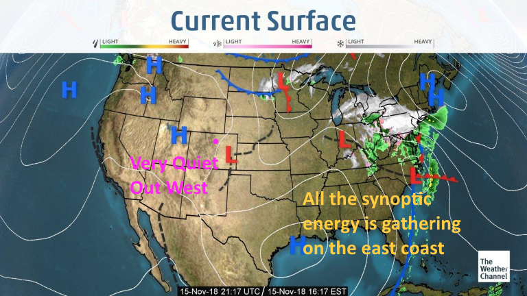
As a giant nor'easter gathers itself on the East Coast, we are high and dry out west (Figure 1). I did want to check on smoke levels and some smoke has leaked across Colorado and into the Midwestern states (Figure 2). There is not 'too' much smoke in the air currently, though. Winds in California have relaxed with high pressure building in from the northwest.

Figure 1: The current surface map from Thursday p.m. and the Weather Channel.

Figure 2: The 24 hour forecast for smoke at all levels from the HRRR model valid Friday midday.

The longer range forecast:

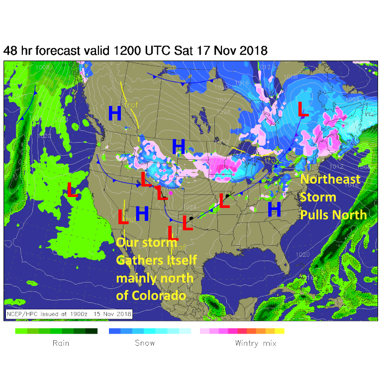
As of Saturday a.m., a low is deepening over northern Colorado and snow is picking up in Wyoming and starting to slip down into our state. The snowfall should fall mainly 4 a.m. to 11 p.m. on Saturday (Figure 3).

Weather underground is still at 1-3" of snow.

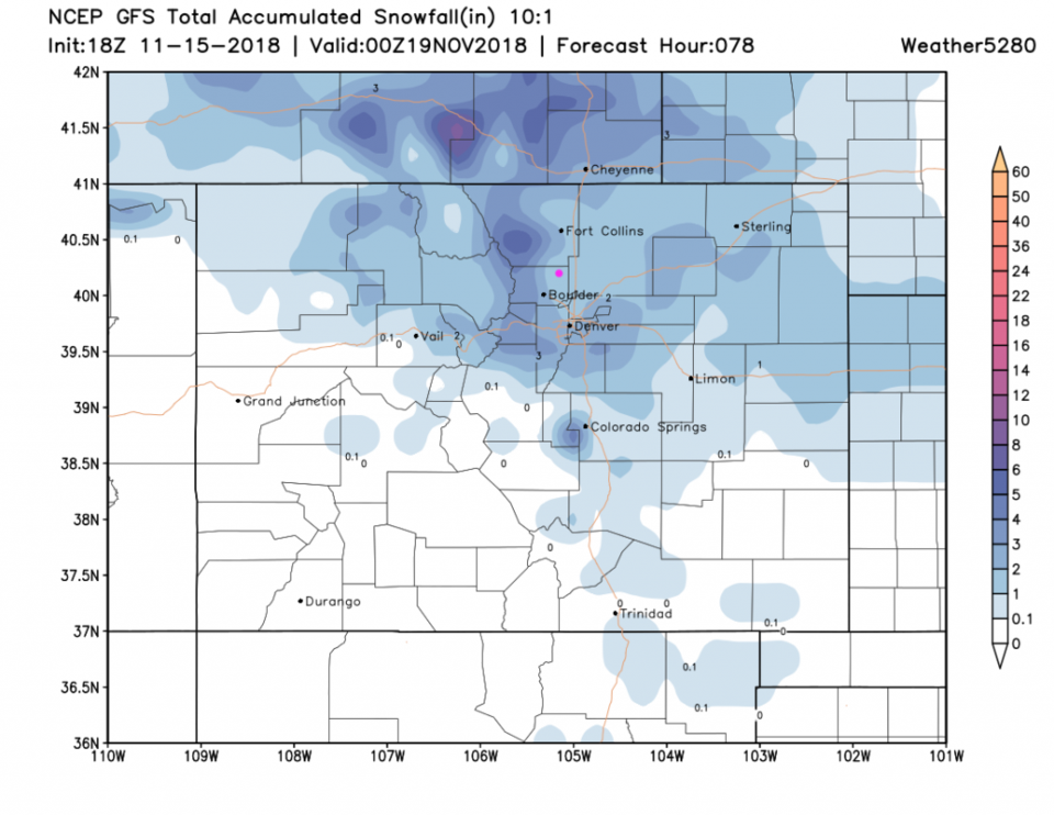
Figure 4- the GFS -has us in the 1-2" of snow.

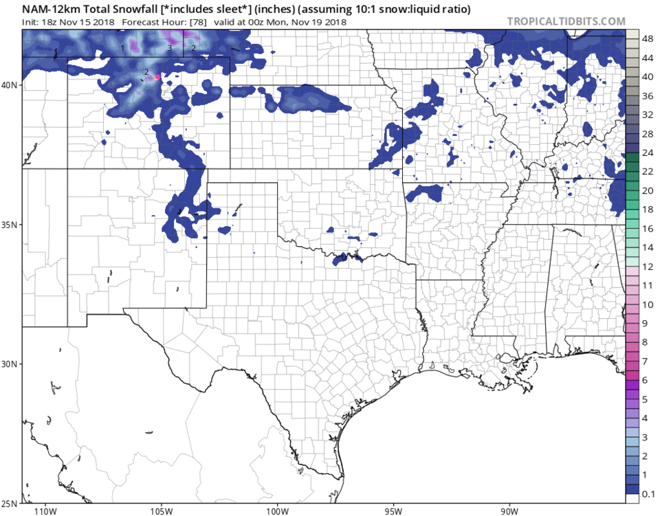
The NAM, Figure 5, has us around 2-3" of snow (but lower just east of downtown Longmont).

No matter what, it will be cold - below freezing for a day, again.

We'll see!

Figure 1: The forecast surface map for Saturday a.m. From NCEP.

Figure 4: The forecast accumulated snow map from the GFS and weather5280.com for Colorado for the next 3 days, through Sunday p.m. Longmont is the pink dot, as always.

Figure 5: The forecast accumulated snow map from the NAM and weather5280.com for Colorado for the next 3 days, through Sunday p.m. Longmont is the pink dot, as always.

Current Weather

Mostly clear

Mostly clear

48°F

UV Index
0 Low
Pressure
30.15 Steady
Visibility
7 miles
Dewpoint
43 °F
Humidity
84%
Wind
NW 1.7 mph
Gust
2.9 mph
Wind Chill
48 °F

Hourly Forecast

Today
1 AM
46°F
Intermittent clouds
Today
2 AM
45°F
Intermittent clouds
Today
3 AM
43°F
Intermittent clouds
Today
4 AM
42°F
Intermittent clouds
Today
5 AM
41°F
Intermittent clouds
Today
6 AM
40°F
Intermittent clouds
Today
7 AM
42°F
Intermittent clouds
Today
8 AM
47°F
Mostly sunny
Today
9 AM
52°F
Mostly sunny
Today
10 AM
57°F
Mostly sunny
Today
11 AM
63°F
Mostly sunny
Today
12 PM
66°F
Mostly sunny

7 Day Forecast

Mostly cloudy w/ showers

Tuesday

63 °F

Turning cloudy and cooler; a passing afternoon shower or two


Mostly cloudy w/ t-storms

Tuesday Night

40 °F

Considerable clouds this evening; partly cloudy late


Mostly sunny

Wednesday

76 °F

Pleasant and warmer with sunshine and patchy clouds


Partly cloudy

Wednesday Night

42 °F

Patchy clouds


Mostly cloudy w/ t-storms

Thursday

73 °F

Becoming cloudy; breezy in the afternoon with a thunderstorm in spots


Cloudy

Thursday Night

48 °F

A thunderstorm in spots in the evening; otherwise, considerable cloudiness


Showers

Friday

69 °F

Mostly cloudy with a couple of showers


Cloudy

Friday Night

46 °F

Cloudy


Showers

Saturday

53 °F

Cloudy and cooler with a couple of showers


Showers

Saturday Night

39 °F

Cloudy with occasional rain and drizzle late


Sunrise and Sunset

Sunrise
6:10 AM
Sunset
7:48 PM

Based on AccuWeather data