Skip to content

3 p.m. Update: Next Storm/Next Snow Forecast Discussion from the Cherrywood Observatory – November 11, 2018

This content was originally published by the Longmont Observer and is licensed under a Creative Commons license.

Forecast Discussion:

3 p.m. Update:

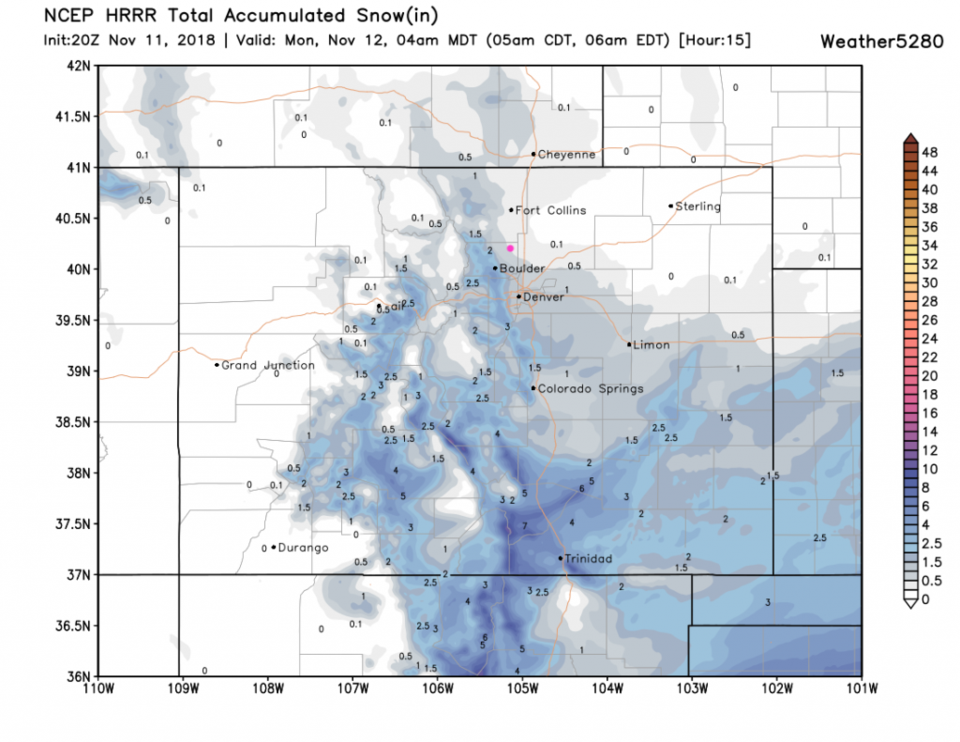
A little more snow will be added to the snow pack, but the snow amounts are going to start tapering off before 6 p.m. The HRRR in Figure 1 update shows about 1 more inch possible overnight.

Figure 1 update: The HRRR snowfall total between 3 p.m. Sunday and 4 a.m. Monday. Longmont is the pink dot.

End 3pm Update.

I won't bury the lead; the NWS has issued a Winter Weather Advisory:

Winter Weather Advisory

Issued: 1:24 PM Nov. 10, 2018 – National Weather Service

...WINTER WEATHER ADVISORY IN EFFECT FROM MIDNIGHT TONIGHT TO

4 PM MST SUNDAY...

* WHAT...Snow expected. Snow accumulations of 3 to 6 inches

expected by late Sunday afternoon.

* WHERE...Boulder and the western suburbs of Denver, Denver and

Castle Rock.

* WHEN...Snow will develop by midnight tonight and be heaviest

Sunday morning. Lighter snow will likely continue into Sunday

evening.

* ADDITIONAL DETAILS...Plan on slippery road conditions.

PRECAUTIONARY/PREPAREDNESS ACTIONS...

A Winter Weather Advisory for snow means periods of snow will

cause primarily travel difficulties. Expect snow covered roads

and limited visibilities, and use caution while driving.

The latest road conditions for the state you are calling from can

be obtained by calling 5 1 1.

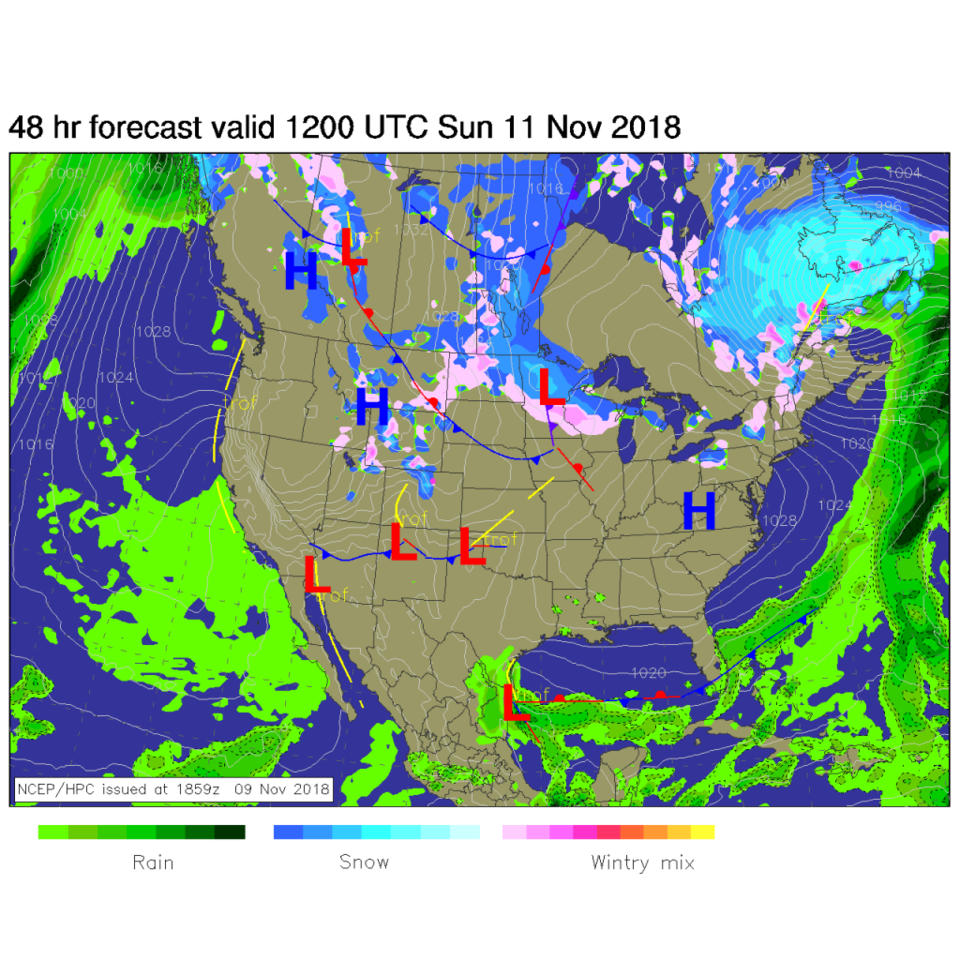
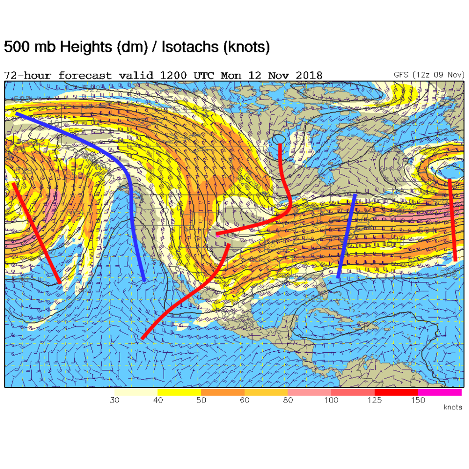
The early morning weather map for Sunday shows the real cold air still coming down with the first front far to the south (Figure 1). The snow is just getting underway along the Front Range. The deep upper level trough (red line(s) in Figure 2) are passing by Monday a.m.

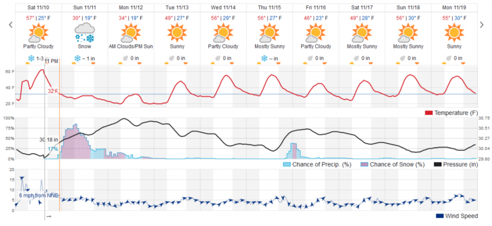
The weatherunderground.com shows precipitation chances starting to pick up around 11 a.m Saturday and really getting going around 6 a.m. Sunday. The snowfall chances drop off around 8 p.m. Sunday, but some precipitation could keep falling through noon Monday now and then (Figure 3).

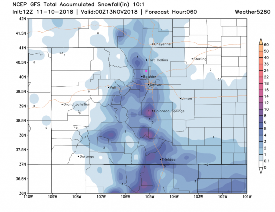
The National Weather Service (NWS), in their statement above, puts 3-6 inches down just to our west, Boulder and the foothills, but also over Denver.

Figure 4, the GFS now has us in the 2-3" zone.

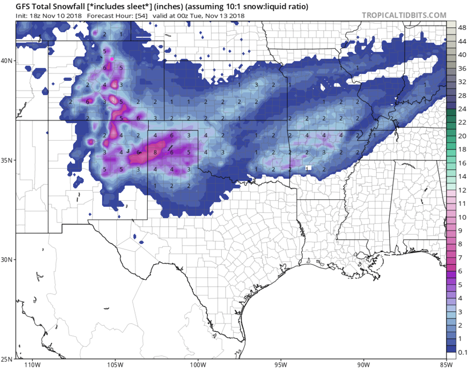
Figure 5 is the GFS again (same model) but pulled out to include the Plains through Monday PM.

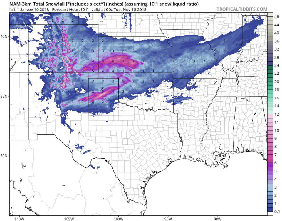
Figure 6 is the NAM model over this region.  We get heavier amounts 3-5" fall around Longmont in this model.

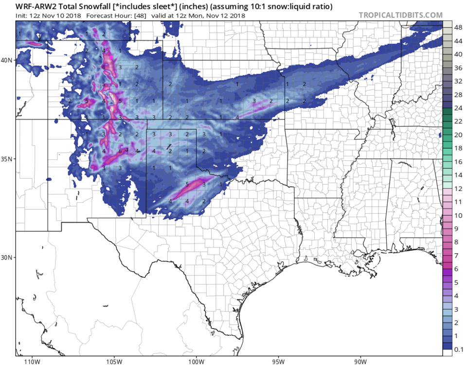
Figure 7 is the WRF model goes even higher with 4-7" over us.

BUT weather5280 forecasters only give Longmont about 1-3". (You can read their discussion here: https://www.weather5280.com/blog/2018/11/10/after-a-mild-saturday-a-cold-veterans-day-with-a-chance-of-snow/).

My forecast is for 2-4" (a bit heavier than weather5280) due to the plentiful cold air (2+ days below freezing) and vigorous upper level support, along with the expected duration of the event.

Figure 1: The forecast surface map for Sunday a.m. From NCEP.

Figure 2: The 500mb forecast upper air analysis for Monday a.m. Pink dot is Longmont. Red lines are troughs, blue lines are ridges.

Figure 3: the piece of the next 10 days of the graphical forecast for Longmont, CO from weatherunderground.com

Figure 4: The forecast accumulated snow map from the GFS and weather5280.com for Colorado for the next 3 days, through Monday p.m. Longmont is the pink dot, as always.

Figure 5: The forecast accumulated snow map from the GFS and tropicaltidbits.com for Colorado for the next 3 days, through Monday p.m. Longmont is the pink dot, as always.

Figure 6: The forecast accumulated snow map from the NAM and tropicaltidbits.com for Colorado for the next 3 days, through Monday p.m. Longmont is the pink dot, as always.

Figure 7: The forecast accumulated snow map from the WRF and tropicaltidbits.com for Colorado for the next 3 days, through Monday a.m. Longmont is the pink dot, as always.

The longer range forecast:

Figure 3, again, shows us staying below freezing (especially if there is a good snow pack) until midday Tuesday. Things remain dry until a small system comes in Friday morning.  More on that later!

Current Weather

Cloudy

Cloudy

36°F

UV Index
0 Low
Pressure
30.26 Rising
Visibility
7 miles
Dewpoint
30 °F
Humidity
81%
Wind
ENE 2.2 mph
Gust
4.4 mph
Wind Chill
36 °F

Hourly Forecast

Today
8 PM
36°F
Cloudy
Today
9 PM
37°F
Cloudy
Today
10 PM
38°F
Cloudy
Today
11 PM
38°F
Cloudy
Tomorrow
12 AM
38°F
Cloudy
Tomorrow
1 AM
37°F
Cloudy
Tomorrow
2 AM
36°F
Cloudy
Tomorrow
3 AM
35°F
Cloudy
Tomorrow
4 AM
35°F
Mostly cloudy
Tomorrow
5 AM
34°F
Mostly cloudy
Tomorrow
6 AM
34°F
Cloudy
Tomorrow
7 AM
35°F
Cloudy

7 Day Forecast

Rain and snow

Thursday

38 °F

Cloudy and much colder; snow showers this morning, accumulating a coating to an inch followed by brief showers this afternoon


Mostly cloudy

Thursday Night

34 °F

Mostly cloudy


Mostly cloudy w/ showers

Friday

47 °F

Chilly with some sun, then turning cloudy; a little rain in the afternoon


Rain and snow

Friday Night

33 °F

Periods of snow; rain mixed in early, accumulating an inch or two


Flurries

Saturday

43 °F

A bit of morning snow with little or no accumulation; otherwise, cloudy and chilly; storm total snowfall an inch or two


Intermittent clouds

Saturday Night

31 °F

Partly cloudy


Partly sunny

Sunday

69 °F

Pleasant and warmer with partial sunshine


Partly cloudy

Sunday Night

44 °F

Partly cloudy


Intermittent clouds

Monday

79 °F

Very warm with a blend of sun and clouds


Intermittent clouds

Monday Night

36 °F

Increasing clouds


Sunrise and Sunset

Sunrise
6:17 AM
Sunset
7:43 PM

Based on AccuWeather data