Skip to content

Next Storm/Next Snow Forecast Discussion from the Cherrywood Observatory – Nov 8-9, 2019

This content was originally published by the Longmont Observer and is licensed under a Creative Commons license.

In Brief:

In typical Colorado fashion, a ridge is passing the state Friday/Saturday will lead to a very comfortable warm up. Then a trough moves in, cold air pours out of Canada Sunday evening and we return to the ice box with a chance of snow/ice again. It is short lived and we pop back to relative warmth on Tuesday and beyond. You are also invited to see a transit of Mercury Monday morning (clouds permitting) at the Cherrywood Observatory. Details below...

Forecast Discussion:

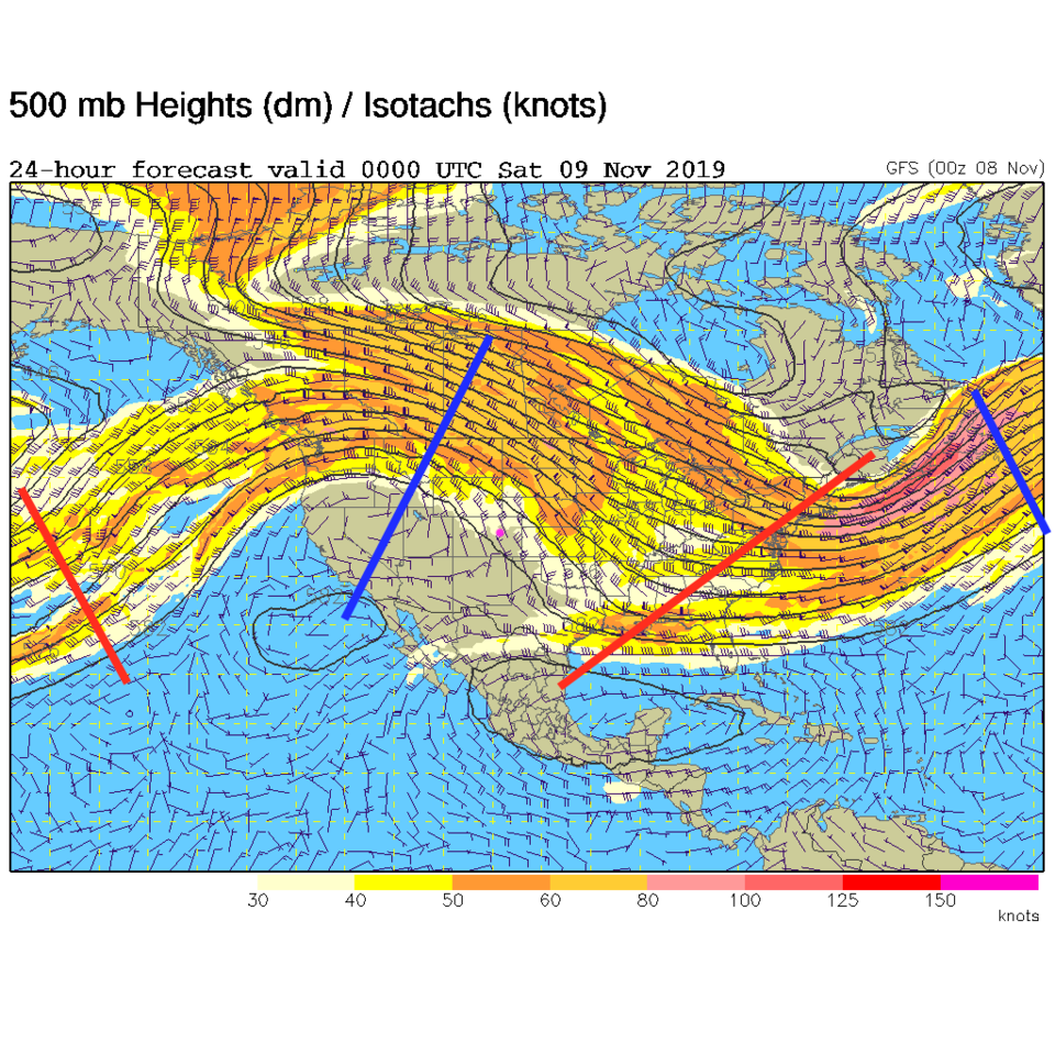
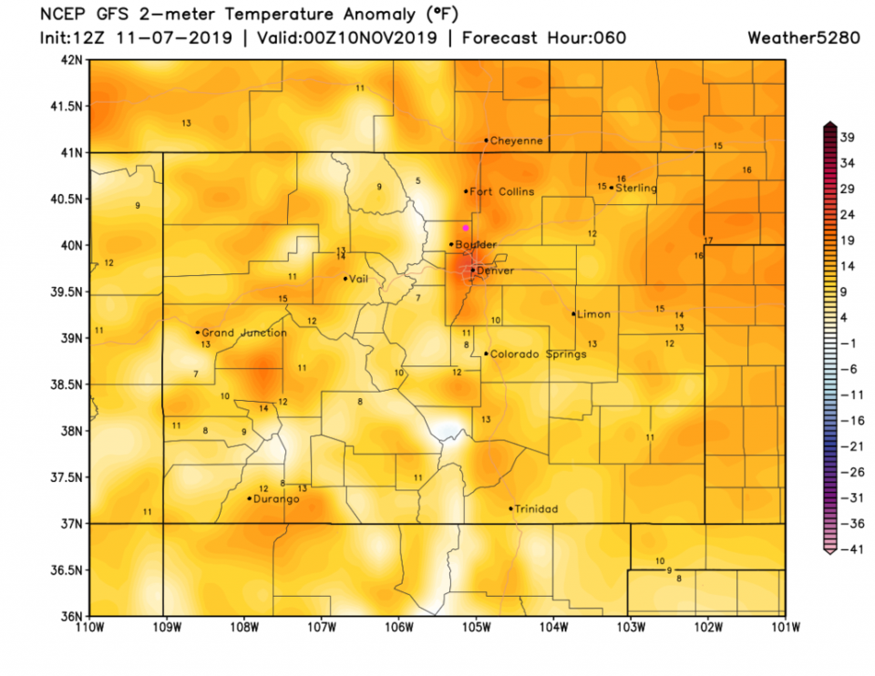
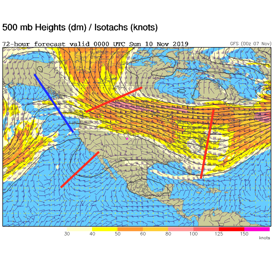
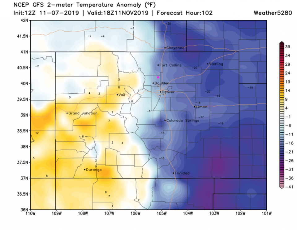
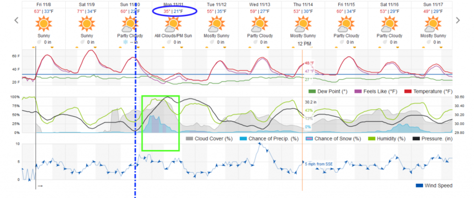
Today and Saturday - we enjoy the wonders of a big ridge (Figure 1) with a bit of down slope flow to warm things a few more degrees. Temperatures Saturday will be up to 10-15 degrees above normal (Figure 2). This warmth comes to an end Sunday afternoon as another front hits around 4pm (Figure 5 - dotted line). This is powered by a fast moving trough and a brief blast of northwesterly winds over the state (Figure 3). The cold air that flows down Sunday is quite shallow and doesn't make it over the mountains to the west (Figure 4).

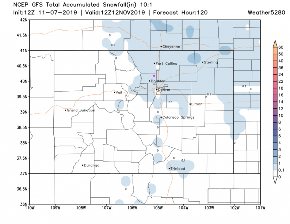
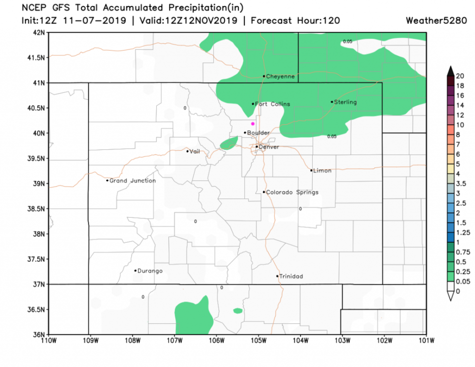
After the front passes, up slope flow and some moisture comes back in. The window for precipitation will run from about 9pm (Sunday) to 9am (Monday). The Plains from the Palmer Divide north should see a coating to an inch of snow (maybe 2 inches in lucky spots- Figure 6) with not much rain- except further north near Wyoming, maybe as far south as Longmont- Figure 7.

The Longer Range Forecast:

The cold air is whisked away on Tuesday and beyond. We don't get really warm, but mild and dry mainly in the 50's for highs all week.

Cherrywood Observatory Mercury Transit Invitation:

Monday morning at sunrise, Mercury will be transiting (crossing the face of the sun like a mini-eclipse). If it is clear, I'll have the telescope set on the sun (with a proper and safe filter) so you can stop by and see the little dot on the face of the sun. I'm near Pace and 17th at the intersection of Cherrywood Dr. and Cherrywood Cir. east of Alpine. The sun should clear my neighbor's house around 7am and the transit ends at 11:04am. I'll be out to peek now and then - just come in the yard and look through the scope in the observatory building.

Figure 1: The 500mb forecast upper air analysis for Friday PM. Pink dot is Longmont. Red lines are troughs, blue lines are ridges.
Figure 2: the surface temperature anomaly (departure from normal) from the GFS for Saturday night from weather5280.com.
Figure 3: The 500mb forecast upper air analysis for Saturday PM. Pink dot is Longmont. Red lines are troughs, blue lines are ridges.
Figure 4: the surface temperature anomaly (departure from normal) from the GFS for Sunday noon from weather5280.com.
Figure 5: the graphical forecast for the next 10 days for Longmont, CO from weatherunderground.com
Figure 6 : The forecast snowfall totals for the next 5 days from the GFS and weather5280com for Colorado made Tuesday noon.
Figure 7: The forecast rainfall totals for the next 5 days from the GFS and weather5280com for Colorado made Tuesday noon.

Current Weather

Cloudy

Cloudy

36°F

UV Index
1 Low
Pressure
30.26 Rising
Visibility
7 miles
Dewpoint
32 °F
Humidity
88%
Wind
NNE 4.4 mph
Gust
8.1 mph
Wind Chill
33 °F

Hourly Forecast

Today
5 PM
40°F
Cloudy
Today
6 PM
39°F
Rain
Today
7 PM
38°F
Rain
Today
8 PM
37°F
Cloudy
Today
9 PM
36°F
Flurries
Today
10 PM
36°F
Cloudy
Today
11 PM
36°F
Rain and snow
Tomorrow
12 AM
36°F
Rain and snow
Tomorrow
1 AM
35°F
Cloudy
Tomorrow
2 AM
35°F
Snow
Tomorrow
3 AM
34°F
Flurries
Tomorrow
4 AM
34°F
Snow

7 Day Forecast

Rain and snow

Friday

41 °F

Chilly; rain and snow showers this morning with little or no accumulation followed by rain and drizzle this afternoon


Rain and snow

Friday Night

33 °F

Periods of snow; rain mixed in early, accumulating 1-3 inches; roads could be slippery


Flurries

Saturday

39 °F

A bit of morning snow with little or no accumulation; otherwise, cloudy and cold; storm total snowfall 1-3 inches


Intermittent clouds

Saturday Night

30 °F

A shower in places in the evening; otherwise, partly cloudy


Partly sunny

Sunday

64 °F

Partly sunny and warmer


Mostly clear

Sunday Night

41 °F

Mainly clear


Intermittent clouds

Monday

79 °F

Warmer with a blend of sun and clouds


Partly cloudy

Monday Night

40 °F

Partly cloudy


Mostly cloudy

Tuesday

66 °F

Mostly cloudy and not as warm


Mostly cloudy

Tuesday Night

40 °F

Mostly cloudy


Sunrise and Sunset

Sunrise
6:15 AM
Sunset
7:44 PM

Based on AccuWeather data