Skip to content

Next Storm/Next Snow Forecast Discussion from the Cherrywood Observatory – May 16, 2019

This content was originally published by the Longmont Observer and is licensed under a Creative Commons license.

In Brief:

We enjoy one more day in the 80'sF - then a vigorous cold front passes over Longmont around noon Friday. With it comes thunderstorms (not looking severe at this time). We cool about 20-30F degrees and may pick up 1- 1.50 inches of rainfall over the next 10 days.

Forecast Discussion:

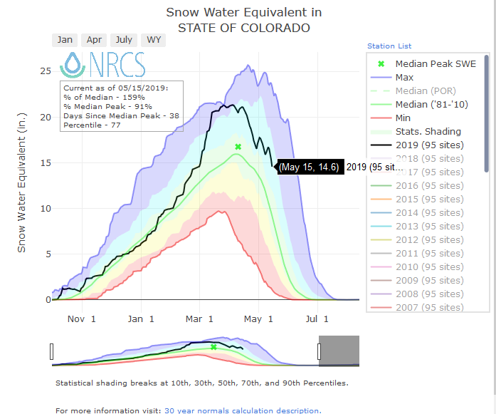
For fun, now that we are hitting 80'sF down here, let's look at this snow-year in review (Figure 1). We are still quite a bit above average for the date (at least one ski resort is going to try to stay open until June). We are at 159% of normal snow pack with a statewide average at 14.6 inches of snow. Last year, on this date, we had about 1/3rd an inch of snow left over the state.

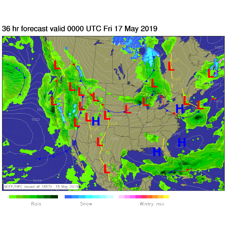
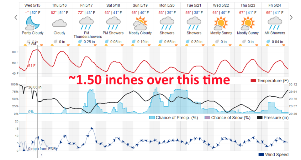
Today (Thursday) the next (really wet) storm is crashing into the west. Flooding has begun in California already (Figure 1). The mountains will wring out most of the moisture before it gets here. We will still hit the lower to mid 80'sF today (Figure 3) with a chance of an afternoon hit-or-miss thundershower moving off the mountains to the northeast.

The Longer Range Forecast:

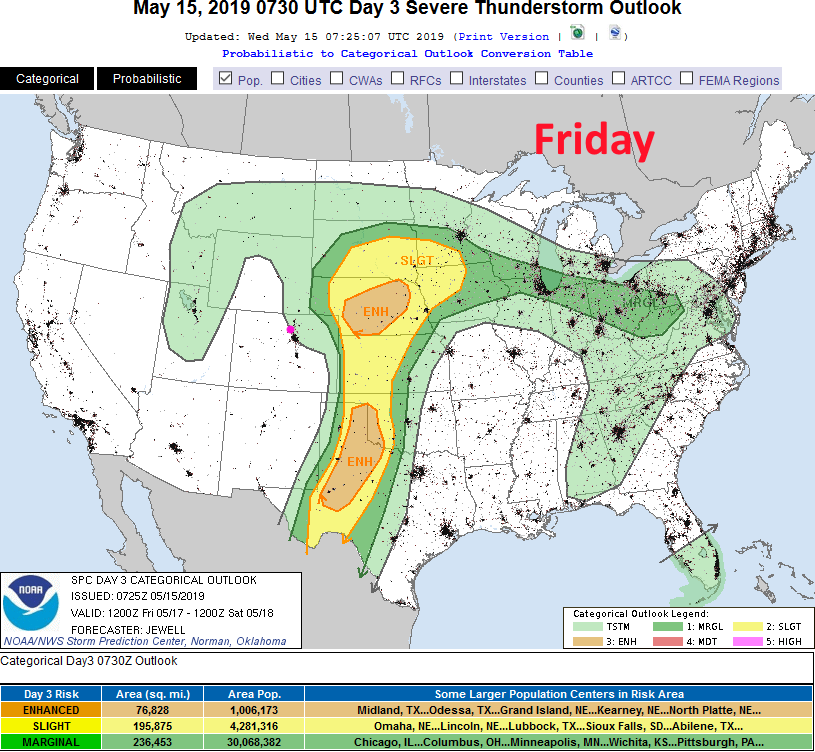
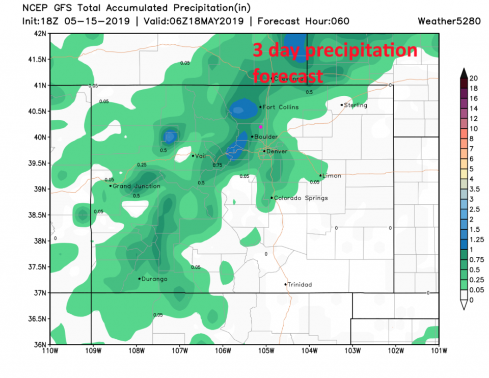
The front arrives midday Friday with a good amount of precipitation and thunderstorm activity (Figure 3). Without enough moisture in place- the severe weather is expected to remain out on the Nebraska and Kansas border and eastward (Figure 4). We'll watch to see if this changes. The GFS shows the southwest to northeast storm tracks on Friday giving us between 0.25 and 0.5 inch of water (Figure 5). The weatherunderground.com model agrees with 0.25 inch of water.

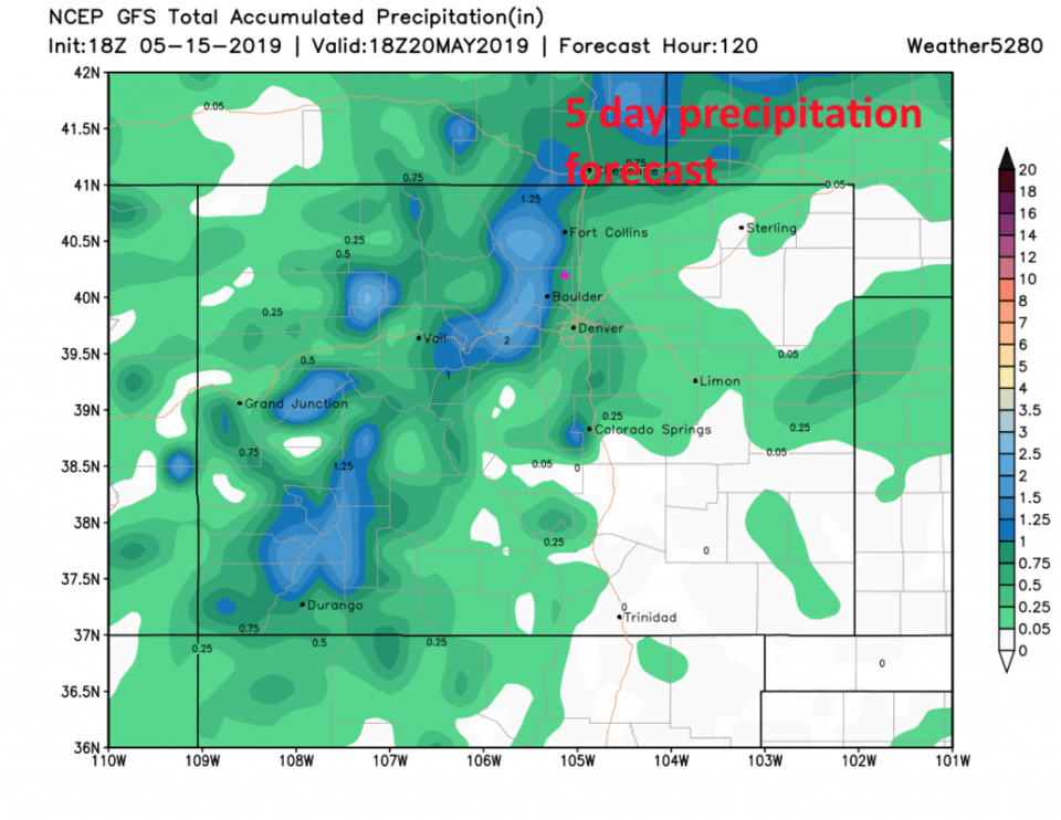
The weatherunderground.com model gives us about 1.50 inches of water over the next 10 days (Figure 3) while the GFS (Figure 6) gives us 0.75 to 1 inch of water over these 10 days. We'll see if anything changes as the weekend approaches.

Figure 1: The snow season trace averaged over all of Colorado. Green line is normal. Black line is 2018-2019. From NRCS and SNOTEL.
Figure 2: The forecast surface map for Friday PM from NCEP.
Figure 3: the graphical forecast for the next 10 days for Longmont, CO from weatherunderground.com
Figure 5: the forecast accumulated precipitation map from the GFS and weather5280.com for Colorado,over the next 3 days.
Figure 6: the forecast accumulated precipitation map from the GFS and weather5280.com for Colorado,over the next 5 days.

Current Weather

Snow

Snow

31°F

UV Index
0 Low
Pressure
30.32 Steady
Visibility
1 miles
Dewpoint
29 °F
Humidity
93%
Wind
NE 1.1 mph
Gust
1.7 mph
Wind Chill
31 °F

Hourly Forecast

Today
7 AM
33°F
Cloudy
Today
8 AM
30°F
Flurries
Today
9 AM
32°F
Flurries
Today
10 AM
33°F
Cloudy
Today
11 AM
34°F
Cloudy
Today
12 PM
35°F
Cloudy
Today
1 PM
37°F
Cloudy
Today
2 PM
38°F
Cloudy
Today
3 PM
40°F
Cloudy
Today
4 PM
39°F
Cloudy
Today
5 PM
39°F
Cloudy
Today
6 PM
38°F
Rain and snow

7 Day Forecast

Rain and snow

Saturday

40 °F

Cloudy and cold; a bit of morning snow followed by a rain or snow shower in spots this afternoon; storm total 1-3"; roads could be slippery


Rain and snow

Saturday Night

32 °F

An evening rain or snow shower in spots; otherwise, partly cloudy


Partly sunny

Sunday

63 °F

Partly sunny and warmer


Mostly clear

Sunday Night

40 °F

Mainly clear


Intermittent clouds

Monday

79 °F

Warmer with intervals of clouds and sun


Partly cloudy

Monday Night

40 °F

Partly cloudy


Mostly cloudy

Tuesday

66 °F

Mostly cloudy and not as warm


Intermittent clouds

Tuesday Night

40 °F

Partly cloudy


Intermittent clouds

Wednesday

79 °F

Warmer with intervals of clouds and sunshine


Intermittent clouds

Wednesday Night

44 °F

Partly cloudy


Sunrise and Sunset

Sunrise
6:14 AM
Sunset
7:45 PM

Based on AccuWeather data