This content was originally published by the Longmont Observer and is licensed under a Creative Commons license.
In Brief:
We warm to the 60'sF today and 70'sF Sunday. We return to the 80'sF by Wednesday. We only have a minor chance of an afternoon -brief- storm Saturday and Tuesday. Nice Spring weather is back.
1pm Update:
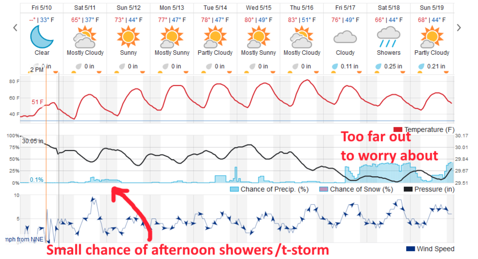
Figure 1 update shows that some (non-severe) convection is possible this afternoon across (almost) the entire state. This is being powered by moisture-in-place, daytime heating, and a short wave coming down out of the north northwest. Spotty showers are occurring across northern Colorado and southern Wyoming at 1pm. There might be a lighting strike or two - maybe a few homes will see small hail in a stronger cell. It is a small fly in the ointment of a great weekend. Enjoy the warm up! Our next significant rain chance is way off at the end of the week.
End 1pm Update.
Forecast Discussion:
I'm going to take tonight off a bit and just point out that the weather will be very nice. Figure 1 shows the weather beginning to warm today with a small chance of an afternoon shower/thunderstorm moving off the mountains.
The Longer Range Forecast:
We warm to the low 80'sF by Wednesday and Thursday. Tuesday and Wednesday may see a few afternoon showers wandering off the high country again (Figure 1). Beyond that there is an indication of a cool down and rain by the weekend, but we'll see. Get away from your computer (after reading some other Longmont Observer headlines and advertisers) and go out and play!