Skip to content

Next Storm/Next Snow Forecast Discussion from the Cherrywood Observatory – March 4, 2019

This content was originally published by the Longmont Observer and is licensed under a Creative Commons license.

Forecast Discussion:

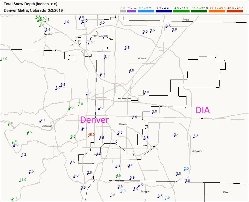
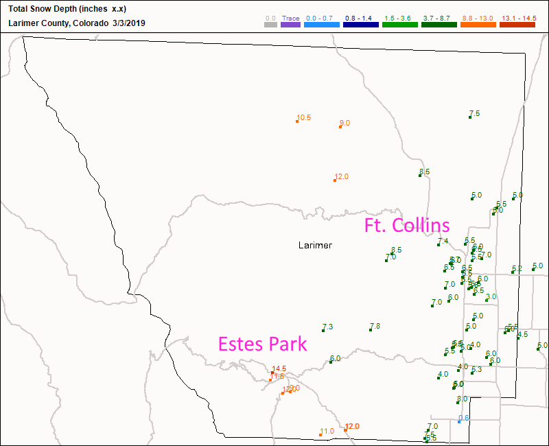
I think I need to recover from all that forecasting excitement, so tonight we'll look back on what did happen. For the three reporting graphics below, add about 1 inch in your mind to make up for compression of the snow over this long event. (I've spot added the two-day totals and 1 inch added to the totals below seems to do well to 'correct' the data.)

For Boulder county (Figure 1), Longmont received about 5 to 5.5 inches while Boulder received about 6 to 6.5 inches of snow. In Denver proper (Figure 2), spots in western Denver seem to have approached 6-8 inches while areas around DIA pulled about 4 inches. Up in Larimer county (Figure 3), Ft. Collins was graced with 7-8 inches and Estes Park pulled a whopping 12-15 inches. RMNP must be impressively buried (Figure 3).

We are very cold today lingering in the lower 20's F with a near zero morning (it is already -1 in Longmont as I type). We'll briefly climb to freezing tomorrow in spite of sunny skies.

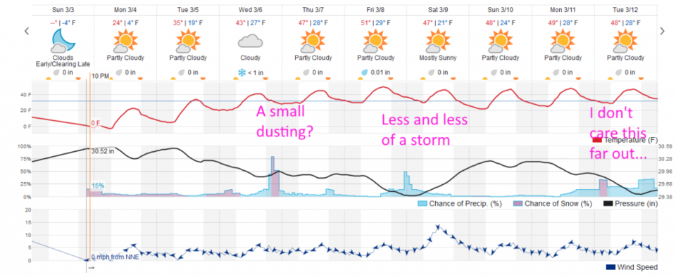
The longer range forecast:

We return to near normal temperatures (highs around 50°F this time of year) by Thursday with very small chances of snow flurries Wednesday PM and Friday PM (Figure 4). There is nothing big on the long range models at this time. Be careful shoveling or sweeping this powder away.

Figure 1: total Snow totals for Friday/Saturday up to 7am for Boulder county from CoCoRaHS.
Figure 2: total Snow totals for Friday/Saturday up to 7am for the Denver metro from CoCoRaHS.
Figure 3: total Snow totals for Friday/Saturday up to 7am for Larimer county from CoCoRaHS.
Figure 4: the graphical forecast for the next 10 days for Longmont, CO from weatherunderground.com

Current Weather

Heavy snow

Heavy snow

33°F

UV Index
0 Low
Pressure
30.32 Steady
Visibility
1 miles
Dewpoint
29 °F
Humidity
87%
Wind
NE 1.1 mph
Gust
1.8 mph
Wind Chill
33 °F

Hourly Forecast

Today
6 AM
33°F
Snow
Today
7 AM
33°F
Cloudy
Today
8 AM
30°F
Flurries
Today
9 AM
32°F
Flurries
Today
10 AM
33°F
Cloudy
Today
11 AM
34°F
Cloudy
Today
12 PM
35°F
Cloudy
Today
1 PM
37°F
Cloudy
Today
2 PM
38°F
Cloudy
Today
3 PM
40°F
Cloudy
Today
4 PM
39°F
Cloudy
Today
5 PM
39°F
Cloudy

7 Day Forecast

Rain and snow

Saturday

40 °F

Cloudy and cold; a bit of morning snow followed by a rain or snow shower in spots this afternoon; storm total 1-3"; roads could be slippery


Rain and snow

Saturday Night

32 °F

An evening rain or snow shower in spots; otherwise, partly cloudy


Partly sunny

Sunday

63 °F

Partly sunny and warmer


Mostly clear

Sunday Night

40 °F

Mainly clear


Intermittent clouds

Monday

79 °F

Warmer with intervals of clouds and sun


Partly cloudy

Monday Night

40 °F

Partly cloudy


Mostly cloudy

Tuesday

66 °F

Mostly cloudy and not as warm


Intermittent clouds

Tuesday Night

40 °F

Partly cloudy


Intermittent clouds

Wednesday

79 °F

Warmer with intervals of clouds and sunshine


Intermittent clouds

Wednesday Night

44 °F

Partly cloudy


Sunrise and Sunset

Sunrise
6:14 AM
Sunset
7:45 PM

Based on AccuWeather data