Skip to content

Next Storm/Next Snow Forecast Discussion from the Cherrywood Observatory – March 30-31, 2019

This content was originally published by the Longmont Observer and is licensed under a Creative Commons license.

Forecast Discussion:

I'm headed out to (snow) camp tonight, so I'll post an update Saturday if needed, otherwise this post will carry through for a couple of days. Since the system is here, I'm posting this early as well.

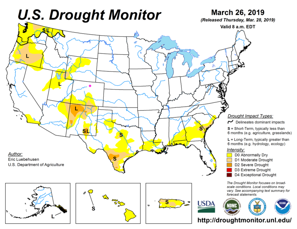
Lets start with the good news before getting to some more good news (if you like snow and precipitation). The latest U.S. Drought Monitor map is out and the entire nation has improved - greatly. There are small areas of only Severe Drought in WA, OR, NM and TX. Our state is almost drought free.

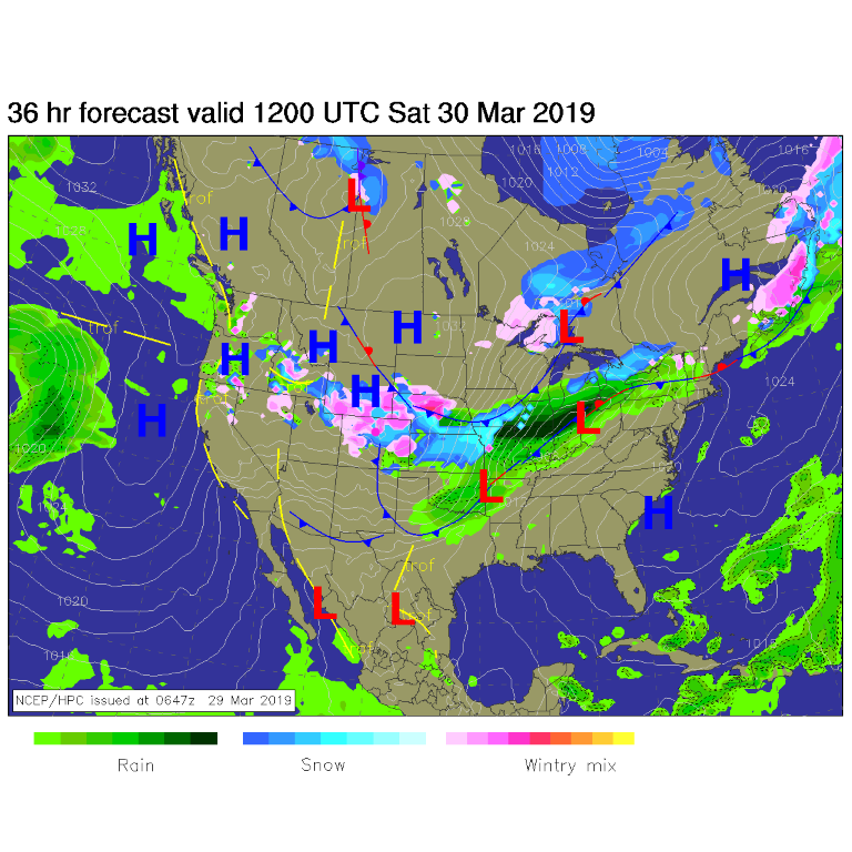
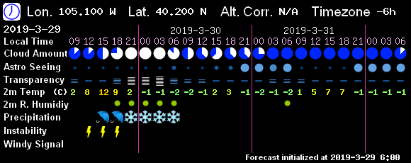
Let's knock the drought down a bit more... the current system has drizzle along I-25 with moist up slope flow. An approaching short wave trough (one of many) that are rolling over the state will increase precipitation (rain at first) this evening - Figure 4 (rain 3pm - 9pm), Figure 9 (3pm to 12am). If the sun comes out this afternoon (Friday) - we might even see a few thunderstorms.

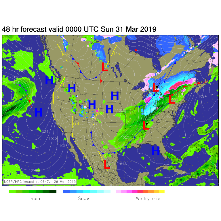
By Saturday morning, snow is falling over much of the state (Figure 2). Precipitation ends around 6am (Figure 4 and 9 again). The system has cleared out of the state (except for the mountains) by Saturday evening (Figure 3).

The precipitation round up:

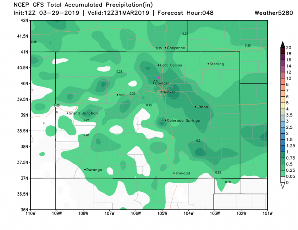
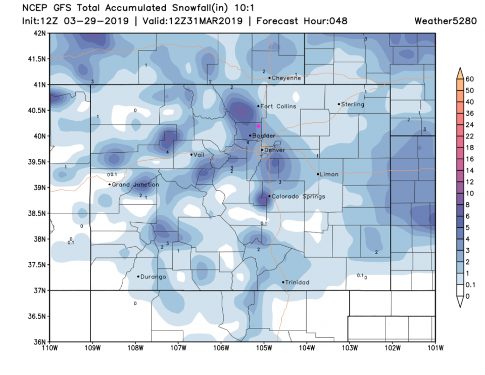
The GFS gives us about 1/2 inch of water (total) in this system (up from yesterday) - Figure 5. This same model now gives east side Longmont about 3-4 inches and west side Longmont about 4-5 inches (Figure 6).

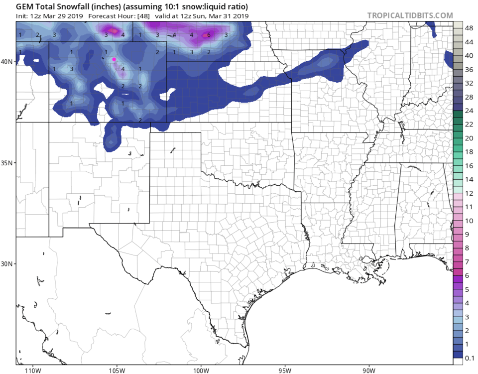
The GEM gives us 2.5-3.5 inches of snow (Figure 7).

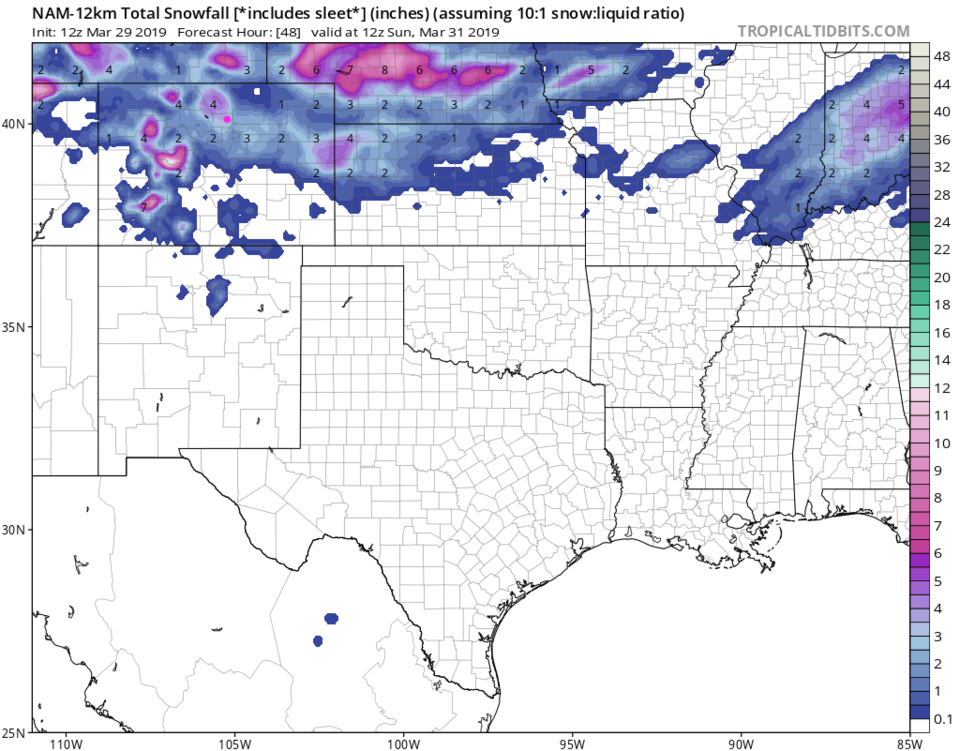
The NAM gives us 2-3 inches of snow (Figure 8).

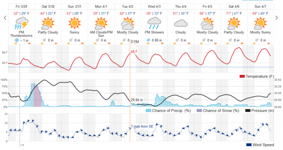
The weatherunderground model (Figure 9) only gives us about 1 inch of snow. An expected dry-slot and warmer temperatures seem to blame.

The longer range forecast:

We pop back to the 50's F Sunday and see 60'sF and dry weather for the first half of the week. There are some showery chances mid-week. We approach 70F next weekend- Figure 9.

More later. See you Monday (unless I can, or need to, sneak in an update).

Figure 1: The current drought index map for Coloado issued Jan 3, 2019 from NOAA/NWS/NCEP/CPC
Figure 2: The forecast surface map for Saturday AM from NCEP.
Figure 3: The forecast surface map for Saturday PM from NCEP.
Figure 3: 7Timer (GFS) forecast for sky conditions and precipitation type for the next 3 days for Longmont.
Figure 5: the forecast accumulated precipitation map from the GFS and weather5280.com for Colorado, through Sunday morning.
Figure 6: the forecast accumulated snowfall map from the GFS and weather5280.com for Colorado, through Sunday morning.
Figure 7: the forecast accumulated snow map from the GEM and tropicaltidbits.com for Colorado, through Sunday morning.
Figure 8: the forecast accumulated snow map from the NAM and tropicaltidbits.com for Colorado, through Sunday morning.
Figure 9: the graphical forecast for the next 10 days for Longmont, CO from weatherunderground.com

Current Weather

Cloudy

Cloudy

46°F

UV Index
0 Low
Pressure
30.33 Steady
Visibility
6 miles
Dewpoint
38 °F
Humidity
72%
Wind
N 1.1 mph
Gust
2.2 mph
Wind Chill
46 °F

Hourly Forecast

Today
6 AM
45°F
Showers
Today
7 AM
45°F
Showers
Today
8 AM
47°F
Showers
Today
9 AM
48°F
Cloudy
Today
10 AM
51°F
Cloudy
Today
11 AM
52°F
Showers
Today
12 PM
54°F
Cloudy
Today
1 PM
56°F
Cloudy
Today
2 PM
57°F
Cloudy
Today
3 PM
58°F
Cloudy
Today
4 PM
59°F
Mostly cloudy
Today
5 PM
59°F
Mostly cloudy

7 Day Forecast

Showers

Friday

59 °F

A couple of morning showers; otherwise, mostly cloudy and cool


Partly cloudy

Friday Night

39 °F

Partly cloudy


Partly sunny w/ t-storms

Saturday

67 °F

Partly sunny with a couple of thundershowers in the afternoon


Thunderstorms

Saturday Night

48 °F

A couple of thundershowers in the evening; mostly cloudy


Rain

Sunday

68 °F

Mostly cloudy with occasional rain and a thunderstorm


Partly cloudy

Sunday Night

41 °F

Partly cloudy


Partly sunny

Monday

75 °F

Partly sunny, pleasant and warmer


Partly cloudy

Monday Night

46 °F

Partly cloudy


Partly sunny w/ showers

Tuesday

78 °F

Intervals of clouds and sunshine with a couple of showers in the afternoon


Thunderstorms

Tuesday Night

49 °F

Mainly cloudy with a couple of showers and a thunderstorm, mainly later


Sunrise and Sunset

Sunrise
5:49 AM
Sunset
8:05 PM

Based on AccuWeather data