Skip to content

Next Storm/Next Snow Forecast Discussion from the Cherrywood Observatory – March 15, 2019

This content was originally published by the Longmont Observer and is licensed under a Creative Commons license.

Forecast Discussion:

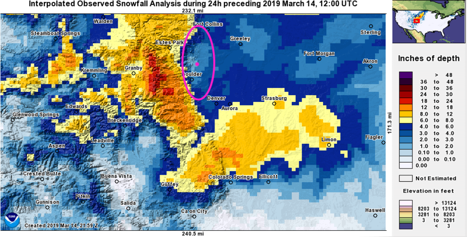
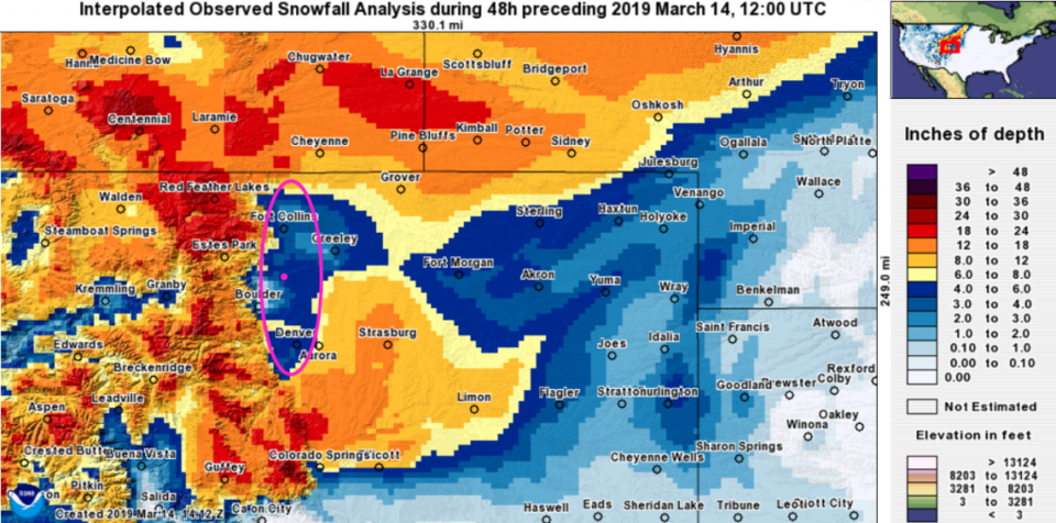
Before we look at the quiet and warm weather ahead of us, let's look back at the snow totals. Figure 1 is the 24 hour snow total before the morning of 3/14 (Pi day). I circled the down-slope snow-hole that was featured in the forecast maps for days last week. It was there! The yellows and reds are 6 to 12 inches of snow. Figure 2 is the 48 hour total which is pretty impressive and features our mega-snow hole again (circled).

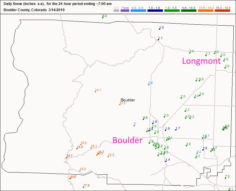
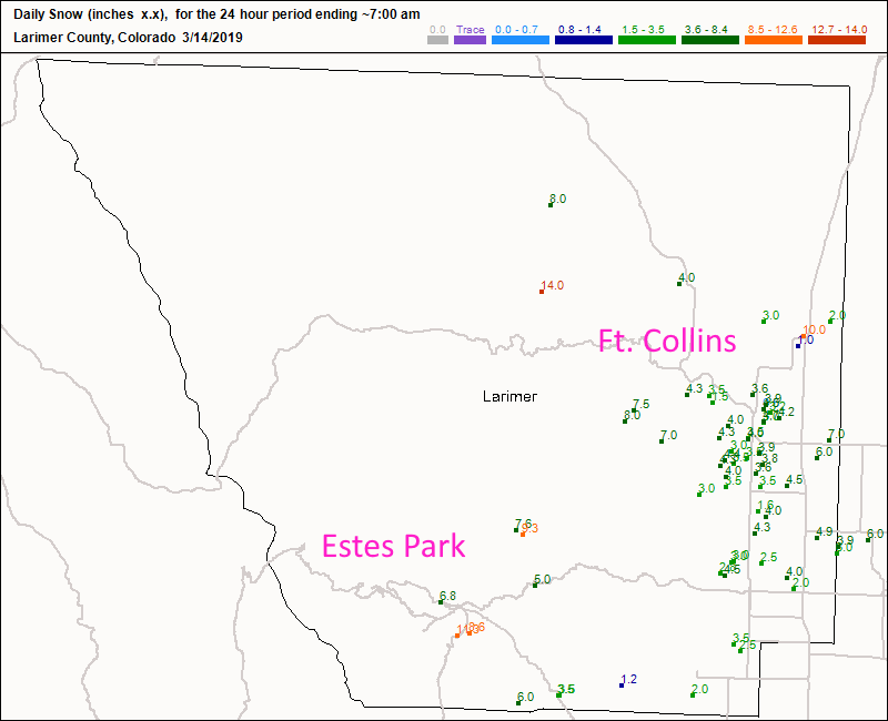
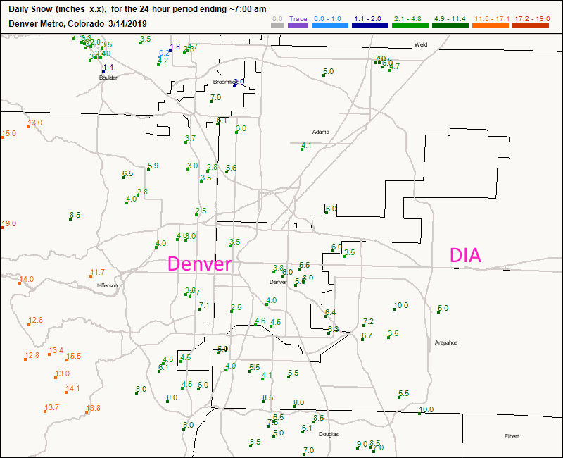
Looking Figure 3, we received about 3-4 inches across town. I forecasted 2-6 inches, so ... pretty good. Figure 4 is Larmier county where the foothills got significant snow. You can scan across the Denver Metro in Figure 5.

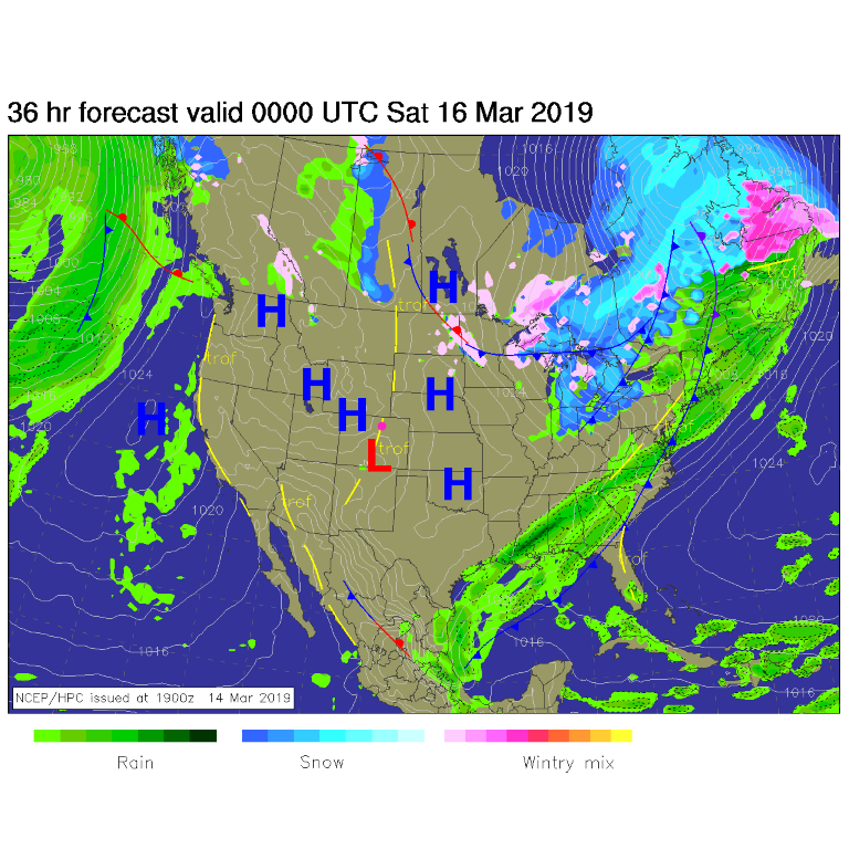
Today we are high and dry with mainly high pressure around the state -Figure 6. Boring, but a nice break.

The longer range forecast:

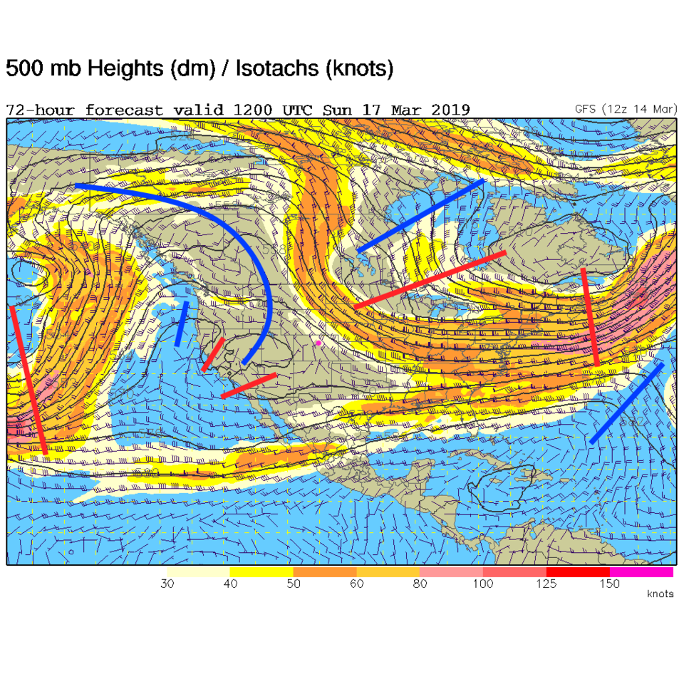
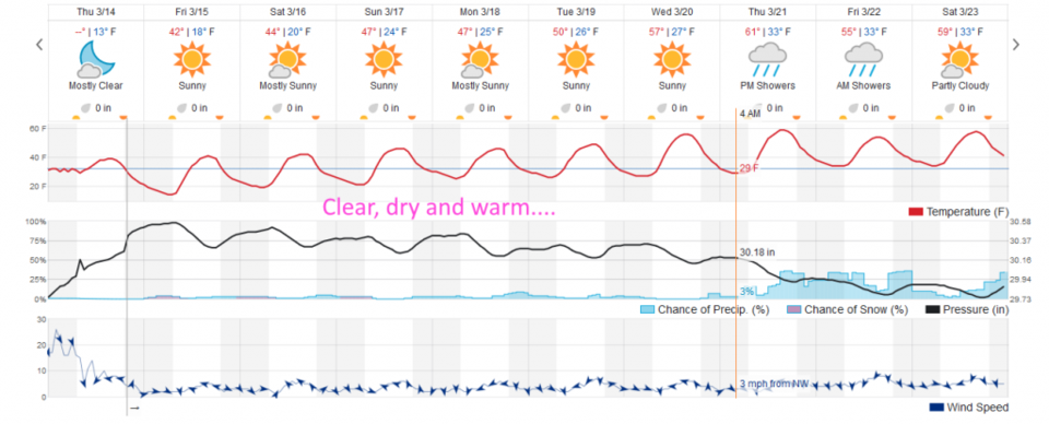
We are sitting with northwest flow aloft into the weekend with a ridge inching toward the state (Figure 7). Each day will be a bit warmer into next week. You can see the temperature trend from the mid-40'sF climbing to the low 60'sF by the end of next week when a bit of rain may arrive. Spring showers?

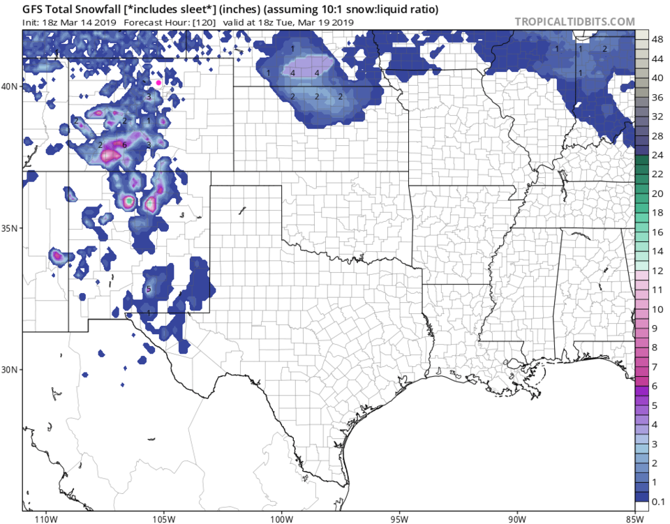
Looking out 5 days, there is just a small amount of mountain snow now and then, but nothing significant around us.

Figure 1: 24 hour snowfall interpolation map from National Weather Service National Operational Hydrologic Remote Sensing Center
Figure 2: 48 hour snowfall interpolation map from National Weather Service National Operational Hydrologic Remote Sensing Center
Figure 3: total new snow totals for Wednesday/Thursday up to 7am for Boulder county from CoCoRaHS.
Figure 4: total new snow totals for Wednesday/Thursday up to 7am for Larimer county from CoCoRaHS.
Figure 5: total new snow totals for Wednesday/Thursday up to 7am for Denver metro from CoCoRaHS.
Figure 6: The forecast surface map for Friday PM from NCEP.
Figure 7: The 500mb forecast upper air analysis for Sunday AM. Pink dot is Longmont. Red lines are troughs, blue lines are ridges.
Figure 8: the graphical forecast for the next 10 days for Longmont, CO from weatherunderground.com
Figure 9: the forecast accumulated snow map from the GFS and tropicaltidbits.com for Colorado, over the next 5 days.


Current Weather

Mostly sunny

Mostly sunny

63°F

UV Index
4 Moderate
Pressure
29.59 Steady
Visibility
7 miles
Dewpoint
37 °F
Humidity
38%
Wind
WNW 4.1 mph
Gust
10.2 mph
Wind Chill
63 °F

Hourly Forecast

Today
10 AM
59°F
Mostly cloudy
Today
11 AM
62°F
Cloudy
Today
12 PM
65°F
Cloudy
Today
1 PM
67°F
Mostly cloudy
Today
2 PM
68°F
Mostly cloudy
Today
3 PM
70°F
Mostly cloudy
Today
4 PM
68°F
Mostly cloudy
Today
5 PM
66°F
Cloudy
Today
6 PM
63°F
Thunderstorms
Today
7 PM
59°F
Cloudy
Today
8 PM
56°F
Cloudy
Today
9 PM
53°F
Cloudy

7 Day Forecast

Mostly cloudy w/ t-storms

Friday

70 °F

Some sun, then increasing clouds with a couple of thundershowers this afternoon; gusty winds and small hail can accompany any downpour


Thunderstorms

Friday Night

44 °F

Cloudy; a couple of showers and a thunderstorm this evening followed by periods of rain late; gusty winds and small hail can accompany any downpour


Rain

Saturday

47 °F

Chilly with periods of rain and a thunderstorm; travel in the foothills and mountains will be slippery due to snow


Rain and snow

Saturday Night

36 °F

Cloudy with rain, mixed with a little snow late; travel in the foothills and mountains will be slippery due to snow


Mostly cloudy

Sunday

61 °F

Mostly cloudy and warmer


Intermittent clouds

Sunday Night

36 °F

A thunderstorm in spots in the evening; otherwise, partly cloudy


Partly sunny

Monday

71 °F

Partly sunny, pleasant and warmer


Partly cloudy

Monday Night

45 °F

Partly cloudy


Mostly sunny

Tuesday

73 °F

Pleasant with sunshine and patchy clouds


Partly cloudy

Tuesday Night

43 °F

Partly cloudy


Sunrise and Sunset

Sunrise
6:06 AM
Sunset
7:51 PM

Based on AccuWeather data