This content was originally published by the Longmont Observer and is licensed under a Creative Commons license.
8:0am Wednesday Update:
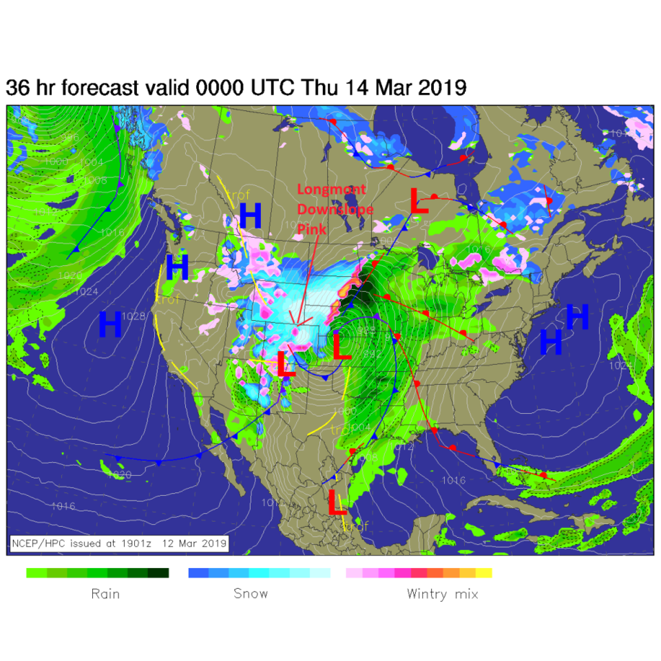
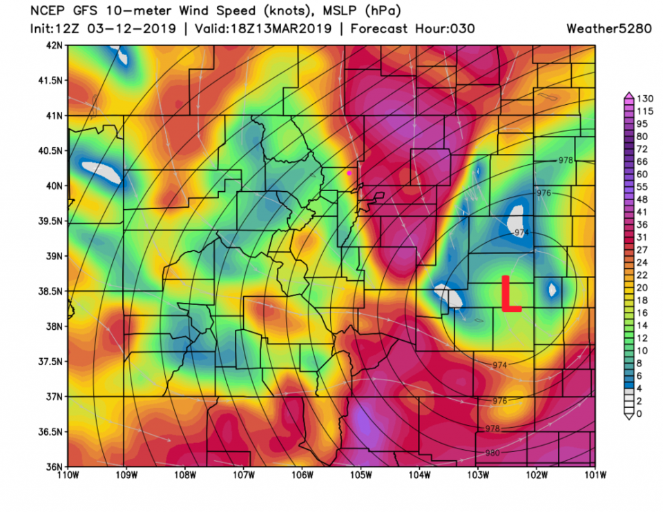
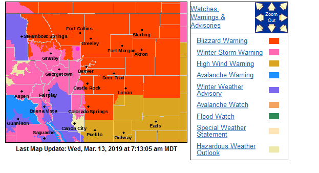
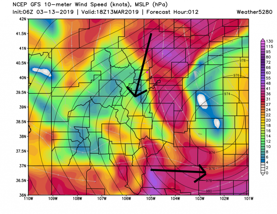
Overnight's data and model runs are indicating a bit of a slowing and more northwesterly track for the storm than was favored yesterday. This means more uplift, more wind energy and snow along I-25. The Blizzard warning has been expanded to include Loveland and Estes Park/RMNP. There is a blizzard warning to our west, north, and east. We are still under a Winter Storm Warning (Figure 3 update).
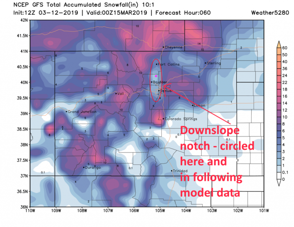
The 'snow free hole' we've been watching, created by predicted down slope flow, is still present in the model output from the GFS (Figure 4 update), but it is filling in with at least 5 inches of snow for Longmont. My forecast yesterday was 3-6" - so we are trending towards the top of my forecast window. The winds at noon today will be northerly (NNE) sustained at about 25mph with higher gusts. We are still looking at very very poor and dangerous travel conditions from noon to 8pm.
We have had about 1/2 inch of rain already today. The change from rain to snow is still most likely to occur around 10-11am.
End 8:00am Update.
9pm Update Tuesday:
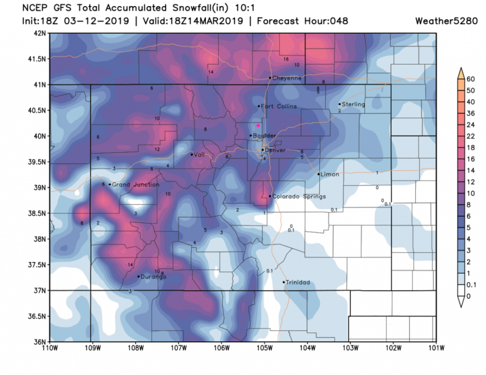
Not much has changed into the evening concerning the storm except that some models have the low trending slightly to the northwest which may mean a bit more snow and wind in the "down slope hole" we've been watching here. Figure 1 update shows rainfall through 10am (about when the rain should change to snow). Longmont is in the 0.5 to 0.75 inch of rain zone according to the HRRR. Figure 2 update is the total snow over the next 48 hours, and the GFS now has us getting 3-4 inches (the GFS was 2-3 inches earlier, below in this column).
Schools and businesses are closing all over the place on the firmness of this serious forecast. Be careful if you MUST drive between 11am and 6pm. It would be best you stay home. My favorite site for school/business closings is from Channel 9 https://www.9news.com/closings Channel 7 Denver also has a good source for these: https://www.9news.com/closings Be safe!

End 9pm Monday Update.
Forecast Discussion:
Let's start off with the warnings. Around Longmont - the most significant feature of the system is the effect of down slope flow. It might keep a narrow strip from Denver to Ft. Collins, just west of I-25, shielded from the worst of the storm raging over the rest of the state. It also might delay the change over from rain to snow in the morning and it might end the snow earlier than it will in the Foothills and out on the Plains. The most severe portion of the storm appears to run from 11am to 3pm with snow tapering off around 9pm Wednesday.
For Longmont, the Blizzard warning (below) applies roughly east of I-25 and the Winter Storm Warning (further below) applies to the west of I-25 up into the nearby hills.
NWS: Blizzard Warning
Area included in alert: Central and South Weld County; North Douglas County Below 6000 Feet/Denver/West Adams and Arapahoe Counties/East Broomfield County
Alert brief: Blizzard Warning issued March 12 at 10:55AM MDT expiring March 14 at 12:00AM MDT by NWS Denver CO
Heavy snow and very strong winds will develop over most of northeast Colorado Wednesday afternoon and Wednesday night. Blizzard conditions are likely to develop along and east of the I- 25 Corridor where the heaviest snow is expected to fall. Power outages and wind damage will also be possible as winds gust to between 60 and 70 mph will be possible. West of the I-25 Urban Corridor, heavy snow and gusty winds will also be possible, with significant travel impacts. Rain is expected to develop Tuesday night, and then change to snow late Wednesday morning and may become heavy at times with wind gusts from 40 to 60 mph. Mountain areas will also see more accumulating snowfall during this period.
* WHAT...Blizzard conditions expected. Total snow accumulations of 5 to 8 inches expected. Winds gusting as high as 60 mph.
* WHERE...Denver and Greeley.
* WHEN...From 10 AM Wednesday to midnight MDT Wednesday night.
* ADDITIONAL DETAILS...Plan on slippery road conditions. Areas of blowing snow will reduce visibility to near zero at times. The hazardous conditions will impact the evening commute. Very strong winds could cause extensive tree damage.
NWS Winter Storm Warning
...WINTER STORM WARNING IN EFFECT FROM 10 AM WEDNESDAY TO MIDNIGHT MDT WEDNESDAY NIGHT...
* WHAT...Heavy snow and blowing snow expected. Total snow accumulations of 3 to 7 inches expected. Winds gusting as high as 60 mph.
* WHERE...The Southern Front Range Foothills, Fort Collins and Boulder and the western suburbs of Denver.
* WHEN...From 10 AM Wednesday to midnight MDT Wednesday night.
* ADDITIONAL DETAILS...Plan on slippery road conditions. Patchy blowing snow could significantly reduce visibility. The hazardous conditions could impact the evening commute. Very strong winds could cause extensive tree damage. PRECAUTIONARY/PREPAREDNESS ACTIONS... A Winter Storm Warning for snow means severe winter weather conditions will make travel very hazardous or impossible. If you must travel, keep an extra flashlight, food and water in your vehicle in case of an emergency. The latest road conditions for the state you are calling from can be obtained by calling 5 1 1. End NWS warnings.
You can see the Blizzard warning in red and the winter storm warning in pink in Figure 1. The forecast surface map for Wednesday afternoon shows the extent of this monster storm with rain or snow from Mexico to Canada and almost coast to coast across the U.S. The (probably record) strong Low Pressure system will be sitting and deepening in western Kansas late Wednesday.
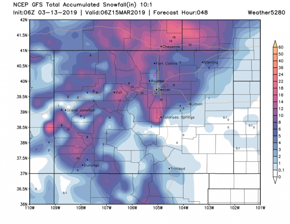
If it weren't for the down slope flow warming, the rain might change to snow around 9am, but the change might hold off until 11a-12p (Figure 3). The (GFS based) model output in Figure 4 shows rain starting 9pm Tuesday and changing to snow at noon Wednesday.
The Model Snowfall Roundup:
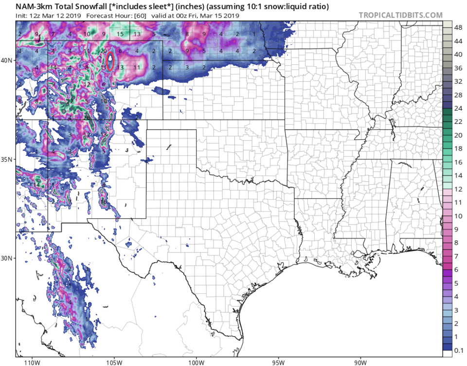
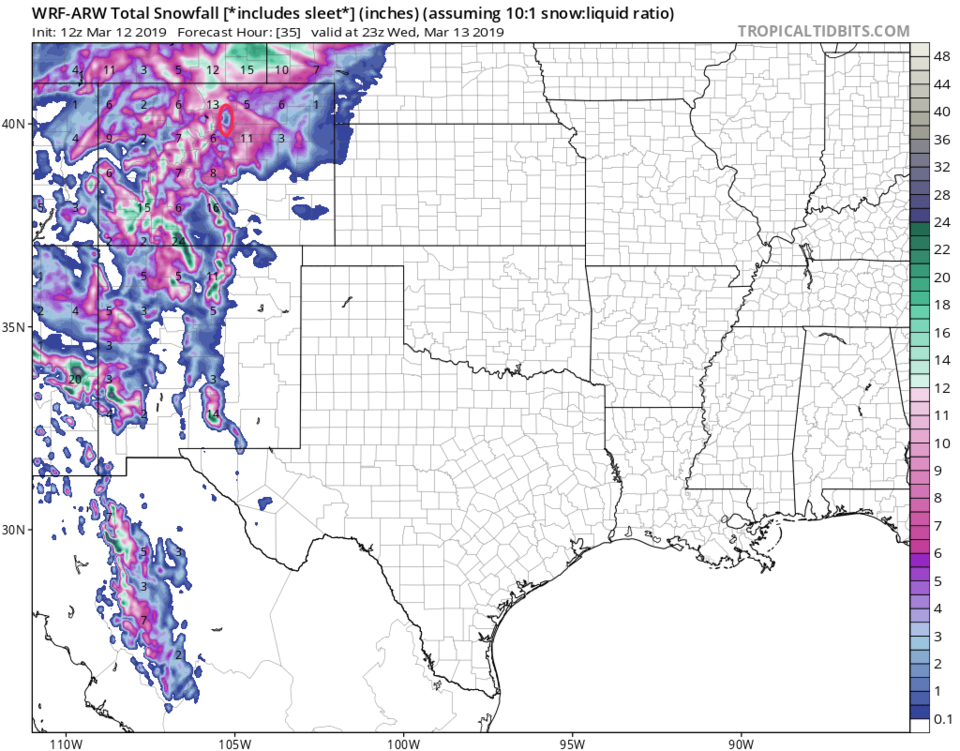
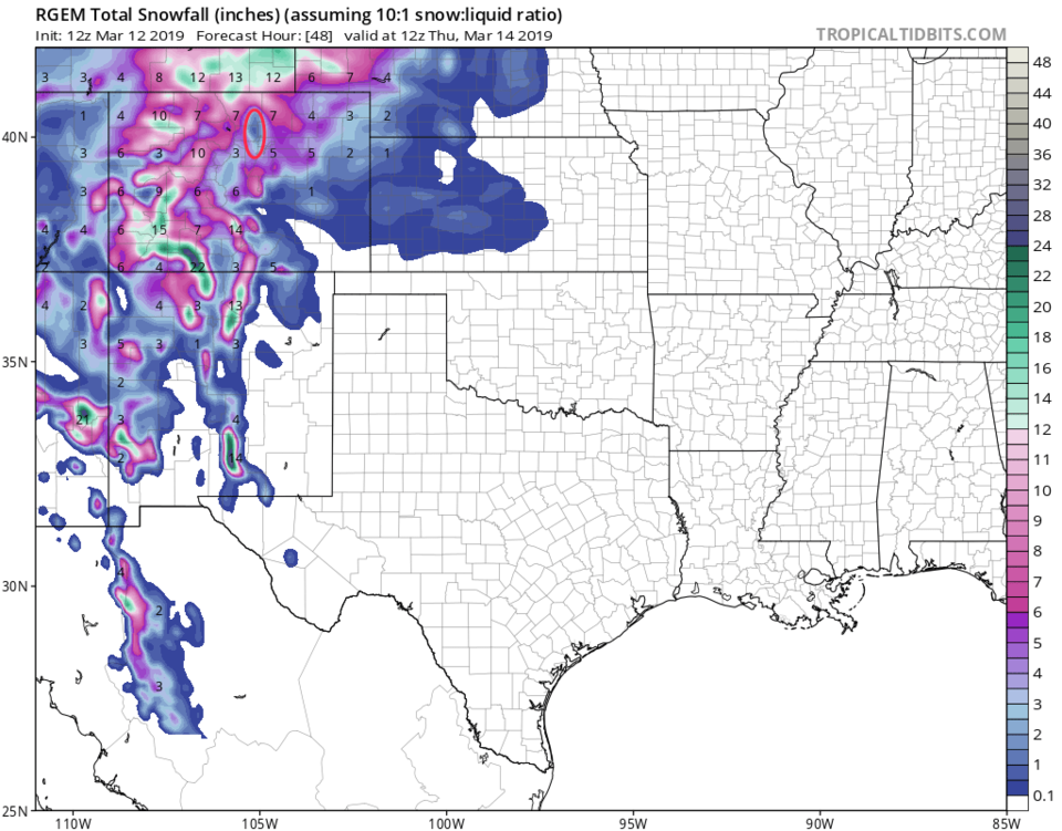
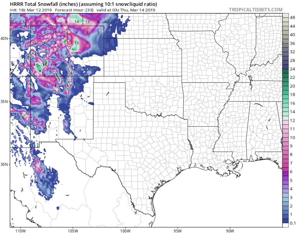
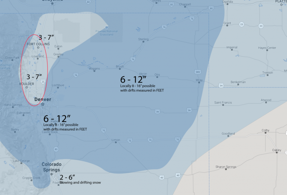
All of these models show the down slope notch west of I-25 from roughly Denver to Ft. Collins - circled in red.
The GFS in Figure 5 gives us 2-3 inches.
The GEM in Figure 6 gives us 3.5-4.5 inches.
The NAM in Figure 7 gives us a dusting to 1/2 inch. (Really!?!)
The WRM in Figure 8 gives us 1-2 inches.
The RGEM in Figure 9 gives us 1-2 inches.
The HRRR in Figure 10 gives us 3-4 inches.
The weather5280.com forecasters are sticking to 3-7".
I'm going with Longmont getting 2-6 inches (just cutting a bit off the wether5280 folks).
Remember the important take-away is that the winds and wind driven snow will be brutal from just before noon into the early evening. White-out conditions will come and go (even with only a few inches of snow ultimately falling around town). Power outages will be possible.
Large snow drifts will form and dangerous hurricane force winds will close roads all over the northeastern and eastern Plains of Colorado. Much of the rest of the mountains and northeastern Colorado will get 1/2 to 1 foot+ of snow.
The longer range forecast:
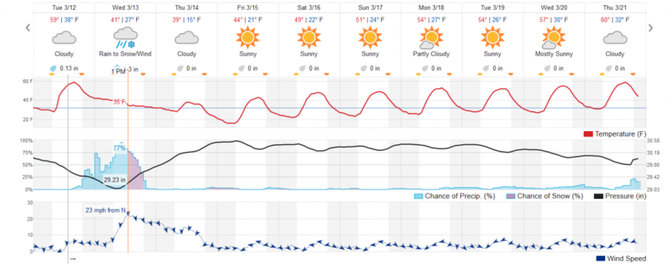
We warm up and dry out returning to near normal temperatures Sunday (53F ish). But is anyone still reading this far down?