Skip to content

Next Storm/Next Snow Forecast Discussion from the Cherrywood Observatory – March 10, 2019

This content was originally published by the Longmont Observer and is licensed under a Creative Commons license.

Forecast Discussion:

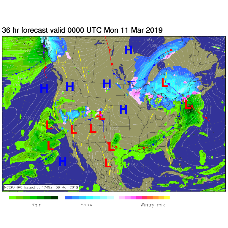
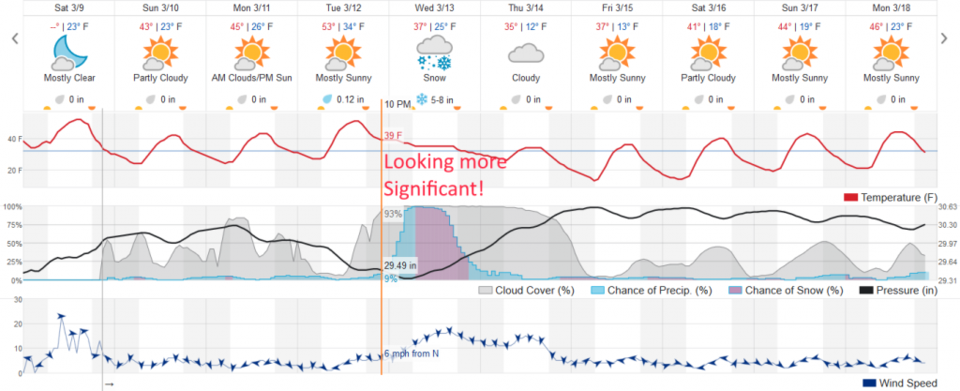
Friday's storm blew through with mainly rain, wind, and snow under the heaver convection (Figure 1). We had only a few 100th's of an inch in town. We have a few, somewhat below normal (temperature-wise - Figure 3 ) days ahead of us as the weekend ends and the week starts. Snow continues in the mountains (Figure 2). What's new?

The longer range forecast:

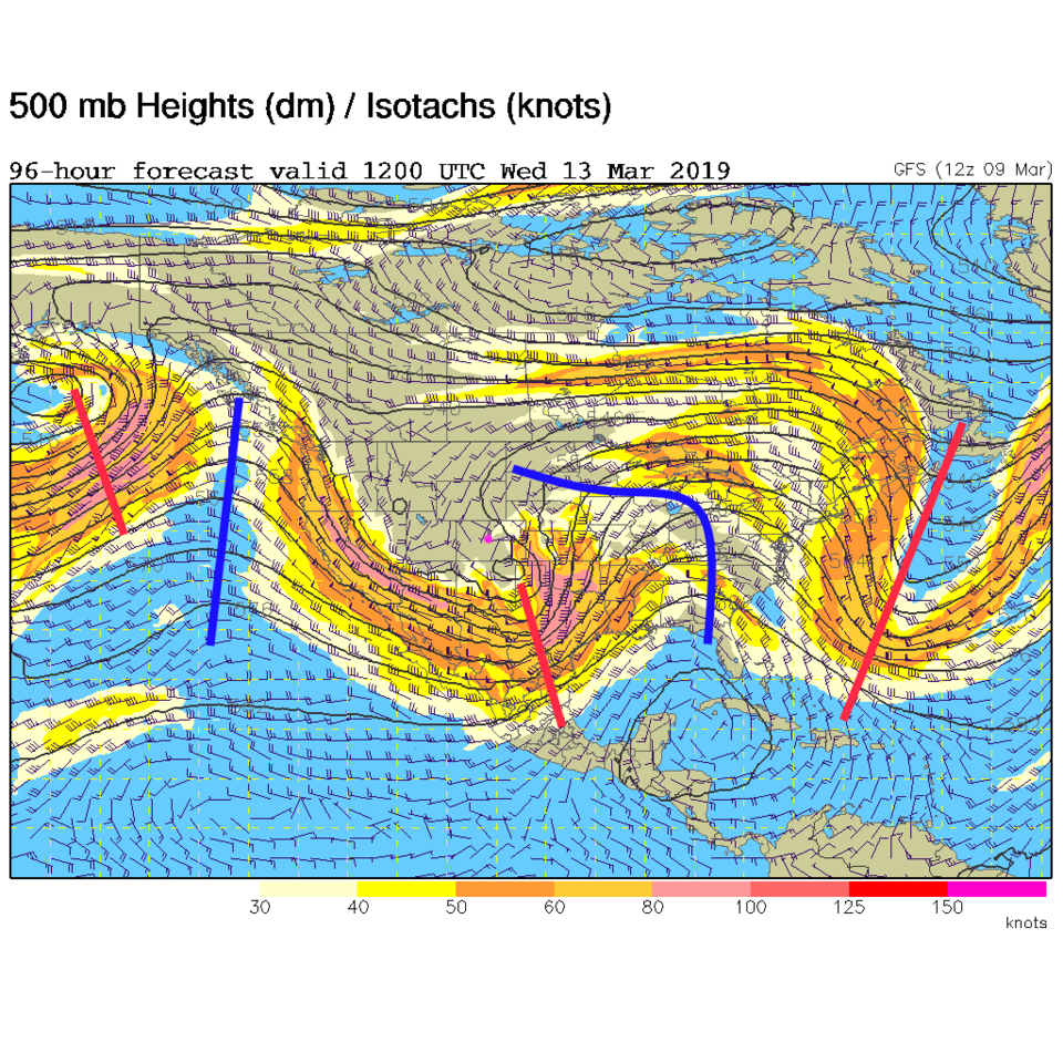
Our mid-week storm is looking better and bigger (if you think a bigger snow storm is better). Figure 2 shows it beginning with rain as warm southwest flow covers the state. The upper-air pattern, in Figure 4, shows what is called a negatively tilted trough over the state Wednesday (the red line upper left to lower right over Colorado). There is even a closed circle over SE Colorado all describing a strong, classic, spring storm with blizzard potential out on the eastern Plains. This will have lift, jet stream support, and strong up flow over NE Colorado, and a lot of moisture (if it pans out).

We are still too far out to be certain, and not all models are creating this scenario, but more are looking to come in line with this picture.

The weatherunderground.com model in Figure 3 shows us getting 5-8 inches of snow.

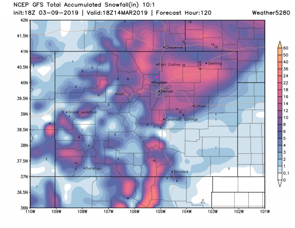
The GFS in Figure 5 also gives us 5-8 inches.

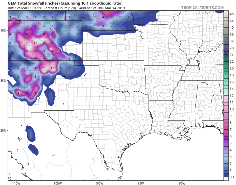
The GEM in Figure 6 is more in the line of 2-4 inches.

Stay tuned!
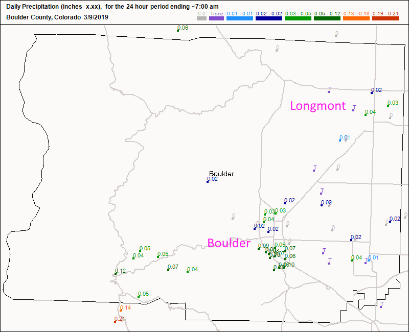
Figure 1: total new snow totals for Friday/Saturday up to 7am for Boulder county from CoCoRaHS.
Figure 2: The forecast surface map for Sunday PM from NCEP.
Figure 3: the graphical forecast for the next 10 days for Longmont, CO from weatherunderground.com
Figure 4: The 500mb forecast upper air analysis for Wednesday AM. Pink dot is Longmont. Red lines are troughs, blue lines are ridges.
Figure 5: the forecast accumulated snow map from the GFS and weather5280.com for Colorado, through the next 5 days.
Figure 6: the forecast accumulated snow map from the GEM and tropicaltidbits.com for Colorado, through the next 5 days.

Current Weather

Clear

Clear

61°F

UV Index
0 Low
Pressure
29.9 Rising
Visibility
7 miles
Dewpoint
42 °F
Humidity
50%
Wind
NNW 3.5 mph
Gust
6.6 mph
Wind Chill
61 °F

Hourly Forecast

Today
10 PM
58°F
Intermittent clouds
Today
11 PM
55°F
Mostly cloudy
Tomorrow
12 AM
53°F
Intermittent clouds
Tomorrow
1 AM
51°F
Partly cloudy
Tomorrow
2 AM
49°F
Mostly clear
Tomorrow
3 AM
47°F
Mostly clear
Tomorrow
4 AM
45°F
Clear
Tomorrow
5 AM
43°F
Mostly clear
Tomorrow
6 AM
41°F
Mostly clear
Tomorrow
7 AM
45°F
Partly sunny
Tomorrow
8 AM
49°F
Partly sunny
Tomorrow
9 AM
55°F
Partly sunny

7 Day Forecast

Mostly sunny

Wednesday

75 °F

Mostly sunny, pleasant and warmer


Partly cloudy

Wednesday Night

41 °F

Patchy clouds


Mostly cloudy w/ t-storms

Thursday

75 °F

Turning cloudy, warm; breezy, a thunderstorm around in the afternoon


Thunderstorms

Thursday Night

49 °F

A thunderstorm in spots in the evening; otherwise, considerable cloudiness


Showers

Friday

70 °F

Mostly cloudy with a couple of showers


Thunderstorms

Friday Night

46 °F

Cloudy with showers and thunderstorms


Rain

Saturday

50 °F

Chilly with periods of rain


Rain and snow

Saturday Night

39 °F

Cloudy with rain, mixed with a little snow late


Mostly cloudy

Sunday

59 °F

Mostly cloudy with a stray thundershower in the afternoon


Partly cloudy

Sunday Night

36 °F

Partly cloudy


Sunrise and Sunset

Sunrise
6:08 AM
Sunset
7:49 PM

Based on AccuWeather data