Skip to content

8:30am Update: Next Storm/Next Snow Forecast Discussion from the Cherrywood Observatory – June 20, 2019

This content was originally published by the Longmont Observer and is licensed under a Creative Commons license.

In Brief:

Today (Thursday) will be quite toasty, but, with our first of 3 cool fronts arriving, highs should fall short of 90F. We cool each day through Sunday when we have highs only in the 60'sF. There are some storm chances this afternoon, then good rain and thunderstorm chances Friday through Sunday. We warm up and dry out and might see our real first 90F+ day Wednesday or Thursday.

8:30am Update:

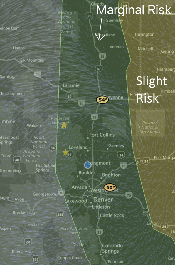
With peak heat today and a return of low level moisture (not to mention a lee trough and the upper air support of the approach of our weekend's trough) - the SPC has expanded the Marginal Risk (1 on a scale of 1-5) to include the mountains from the Divide eastward onto the Plains (Figure 1 update). Further out on the Plains, there is a Slight Risk (2 on a scale of 1-5). The primary threat in the Marginal Risk zone is for large hail and damaging winds with the stronger storms. In the Slight Risk zone, there is a chance for isolated tornadoes.

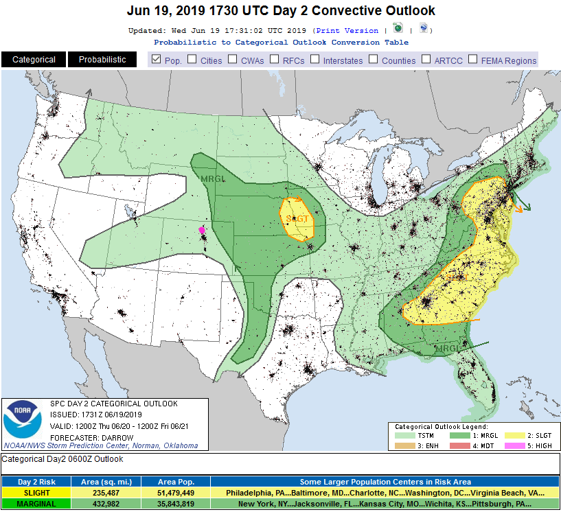
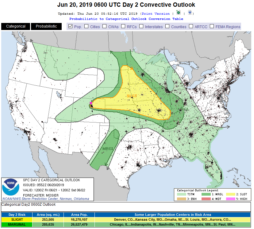
For Friday, the Slight Risk (hail and tornadoes and wind) is already back to I-25 communities from south of Denver up to about Loveland (Figure 2 update). The trend, often, is for the Day 2 forecast to expand westward once data comes in overnight. We'll watch this in the daily updates!

Figure 1 update: The severe storm weather forecast for the U.S. from the Storm Predication Center in Norman, OK. Made Thursday for Thursday overlay on a radar may from MyRadar app IOS.
Figure 2 update: The severe storm weather forecast for the U.S. from the Storm Predication Center in Norman, OK. Made Thursday for Friday.

End 8:30am Update.

Forecast Discussion:

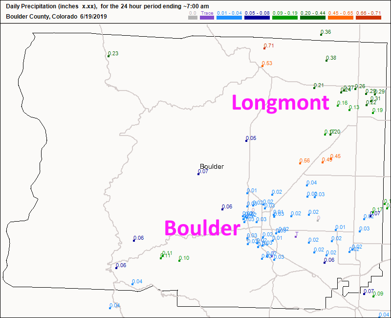
More rain has fallen. Thundershowers brought in another 1/3rd inch of rainfall to town Tuesday/Wednesday (Figure 1). We are still 100% drought free across Colorado.

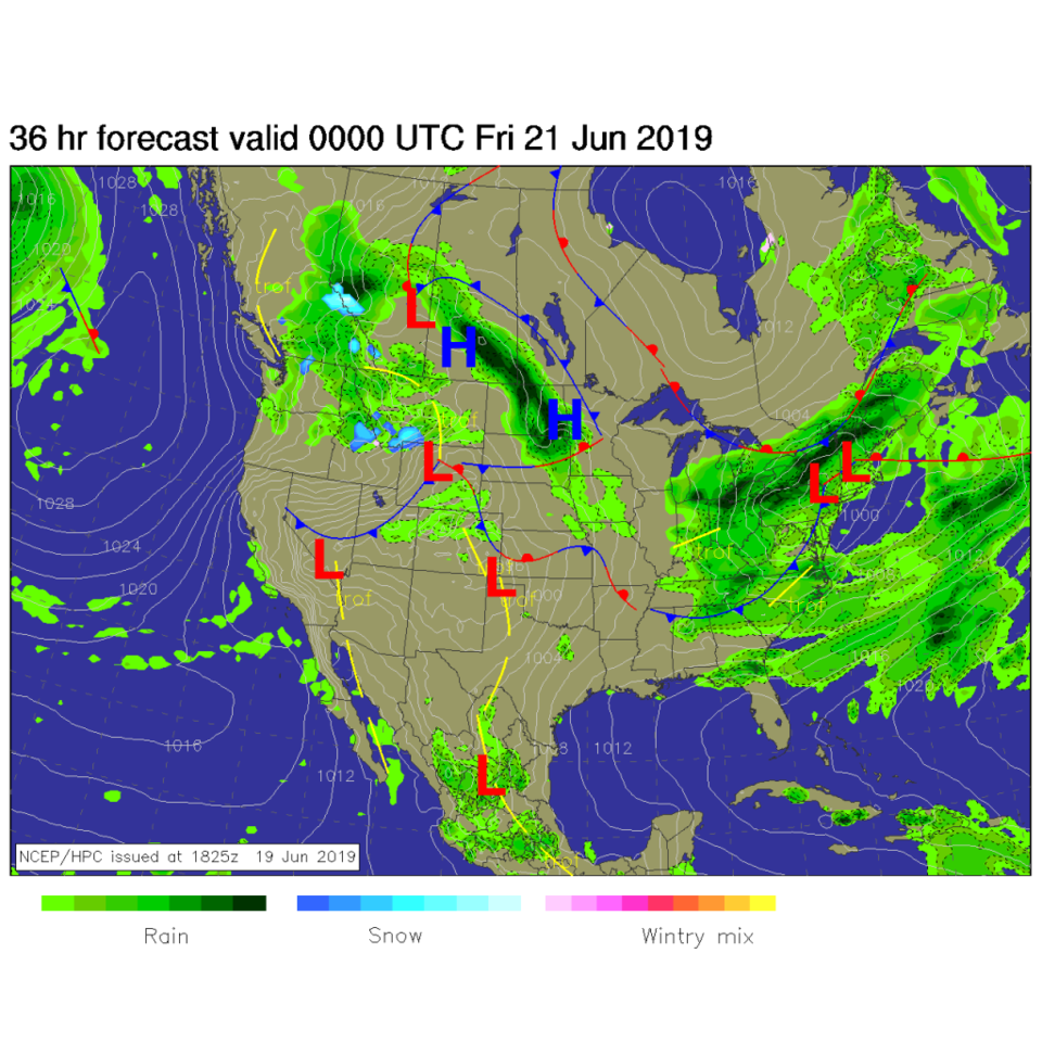
Today (Thursday) high pressure dominates but a front is sneaking into the NE Plains to hit Longmont mid-afternoon. Friday's front is sweeping down across Utah and Wyoming today (Figure 2). There are some storm chances with this first front today but the risk of severe weather remains out on the Plains (but not too far away - Figure 4).

The Longer Range Forecast:

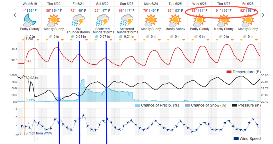
Our next, stronger front comes in midday Friday and rain and thunderstorm chances increase dramatically (Figure 3). The weatherunderground.com model gives us almost 1.5 inches of water over this weekend.

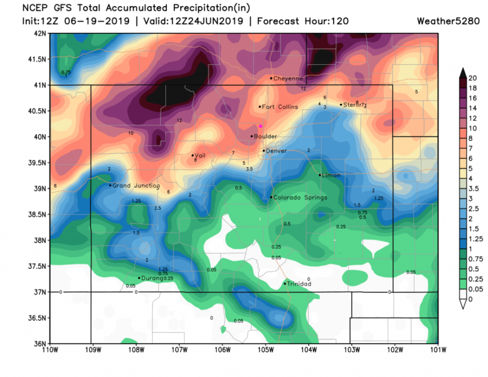
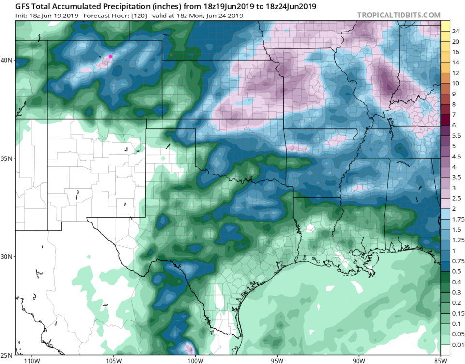
The (possibly the newly released, retooled) GFS at weather5280.com goes a bit crazy with rainfall totals with 5 to 20+ inches across northern Colorado over the next 5 days (this is an output error - Figure 5). The GFS at tropicaltidbits.com is more reasonable but gives Boulder over 2 inches and we almost reach 2 inches (Figure 6). This is looking wet.

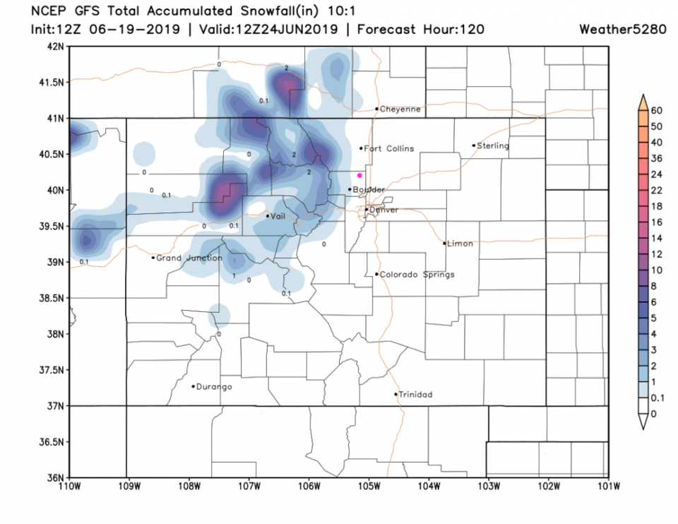
And cold - snow levels should drop below 10,000 feet and maybe further down - Figure 7. I doubt Boulder gets a dusting though. More output error?

Figure 1: total new rainfall totals for Tuesday/Wednesday up to 7am for Boulder county from CoCoRaHS.
Figure 2: The forecast surface map for Thursday PM from NCEP.
Figure 3: the graphical forecast for the next 10 days for Longmont, CO from weatherunderground.com
Figure 4: The severe storm weather forecast for the U.S. from the Storm Predication Center in Norman, OK. Made Wednesday for Thursday.
Figure 5: the forecast accumulated precipitation map from the GFS and weather5280.com for Colorado,over the next 5 days.
Figure 6: the forecast accumulated precipitation map from the GFS and tropicaltidbits.com for Colorado,over the next 5 days.
Figure 7: the forecast accumulated snowfall map from the GFS and weather5280.com for Colorado,over the next 5 days.

Current Weather

Mostly cloudy

Mostly cloudy

62°F

UV Index
1 Low
Pressure
29.65 Rising
Visibility
7 miles
Dewpoint
38 °F
Humidity
42%
Wind
NE 5.7 mph
Gust
10.7 mph
Wind Chill
62 °F

Hourly Forecast

Today
7 PM
60°F
Thunderstorms
Today
8 PM
56°F
Cloudy
Today
9 PM
52°F
Cloudy
Today
10 PM
50°F
Thunderstorms
Today
11 PM
48°F
Thunderstorms
Tomorrow
12 AM
46°F
Cloudy
Tomorrow
1 AM
46°F
Cloudy
Tomorrow
2 AM
45°F
Cloudy
Tomorrow
3 AM
44°F
Rain
Tomorrow
4 AM
44°F
Cloudy
Tomorrow
5 AM
44°F
Rain
Tomorrow
6 AM
44°F
Rain

7 Day Forecast

Mostly cloudy w/ t-storms

Friday

69 °F

Variable cloudiness with a couple of thundershowers this afternoon; gusty winds and small hail can accompany any downpour


Thunderstorms

Friday Night

41 °F

Cloudy; a couple of showers and a thunderstorm this evening followed by periods of rain late; gusty winds and small hail can accompany any downpour


Rain

Saturday

44 °F

Chilly with periods of rain and a thunderstorm; travel in the foothills and mountains will be slippery due to snow


Rain and snow

Saturday Night

36 °F

Cloudy with rain, mixed with a little snow late; travel in the foothills and mountains will be slippery due to snow


Mostly cloudy

Sunday

61 °F

Mostly cloudy and warmer


Intermittent clouds

Sunday Night

36 °F

A thunderstorm in spots in the evening; otherwise, partly cloudy


Partly sunny

Monday

71 °F

Partly sunny, pleasant and warmer


Partly cloudy

Monday Night

45 °F

Partly cloudy


Mostly sunny

Tuesday

73 °F

Pleasant with sunshine and patchy clouds


Partly cloudy

Tuesday Night

40 °F

Partly cloudy


Sunrise and Sunset

Sunrise
6:06 AM
Sunset
7:51 PM

Based on AccuWeather data