Skip to content

Next Storm/Next Snow Forecast Discussion from the Cherrywood Observatory – July 31, 2019

This content was originally published by the Longmont Observer and is licensed under a Creative Commons license.

In Brief:

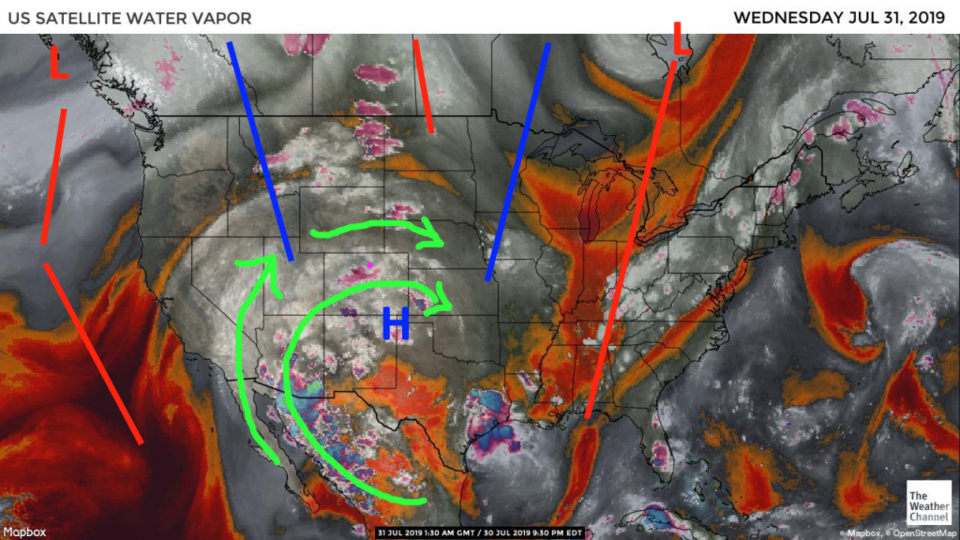
The moisture flow has improved and afternoon storm chances are getting better. We won't see extreme heat for a while, but the air will get noticeably more sticky feeling. A short wave and associated weak front will move through the state Thursday leading to our best chance of measurable rainfall and thunderstorms out of the next week to 10 days.

Forecast Discussion:

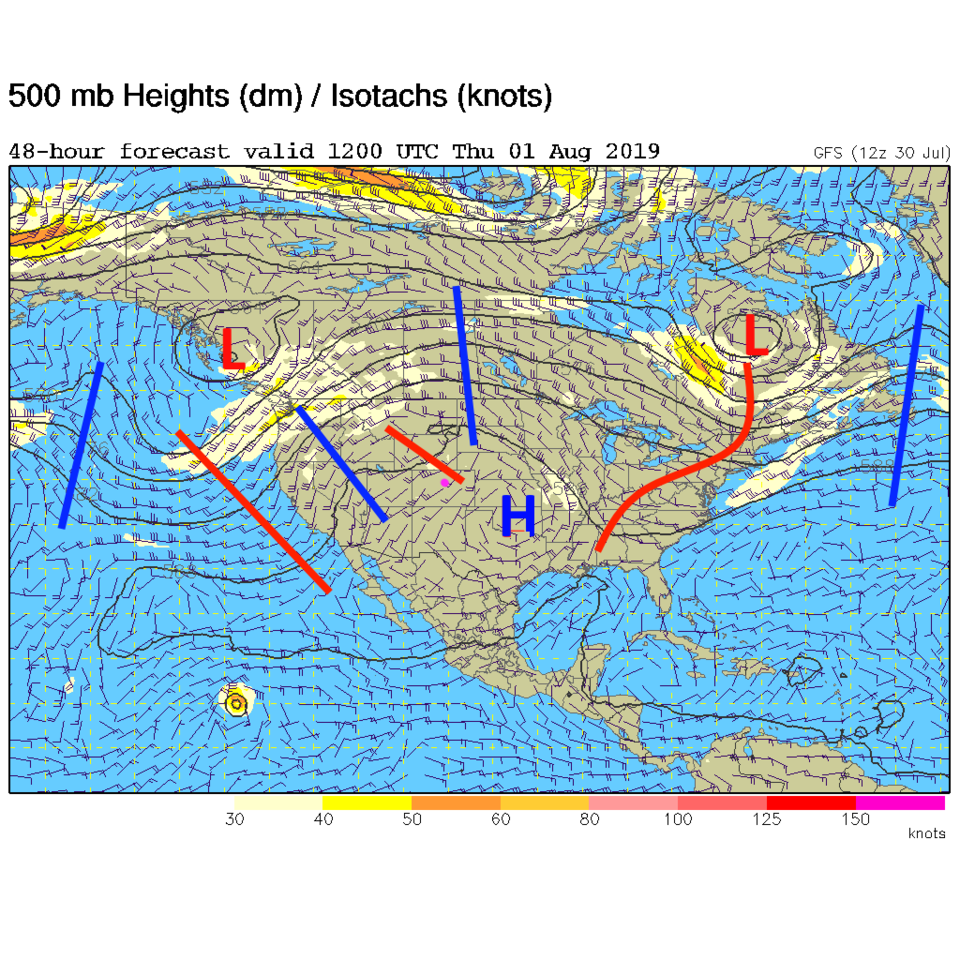
The water vapor satellite image shows a dramatic improvement of moisture flow over Colorado from the tropics (see the discussion for Monday for the progression in images - Figure 1). This is because the upper-level high center has shifted almost to the Texas panhandle (Figure 2). I drew the troughs and ridges and height centers on Figure 2 back on Figure 1 so you can see the reflection of air flow patterns in the moisture image.

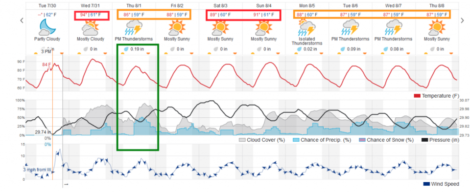
For today (Wednesday)- we'll see more cloud cover and a bit better chance of a storm than we saw Tuesday (Figure 3).

The Longer Range Forecast:

A trough will cut into the ridge and pass over Colorado Thursday (Figure 4) and will bring a wind shift, surface convergence and an enhanced chance of storms and wider-spread rainfall (Figure 3). Beyond that we hover in the upper 80's F and lower 90's F with daily thunderstorm chances.

Figure 1: the water vapor satellite image (browns/reds are dry air, whites and light grey is moist air, purple/blue is ice and high cloud tops). From the the Weather Channel from Tuesday.
Figure 2: The 500mb forecast upper air analysis for Wednesday AM. Pink dot is Longmont. Red lines are troughs, blue lines are ridges.
Figure 3: the graphical forecast for the next 10 days for Longmont, CO from weatherunderground.com
Figure 4: The 500mb forecast upper air analysis for Thursday AM. Pink dot is Longmont. Red lines are troughs, blue lines are ridges.

Current Weather

Mostly cloudy

Mostly cloudy

47°F

UV Index
0 Low
Pressure
29.57 Falling
Visibility
8 miles
Dewpoint
41 °F
Humidity
79%
Wind
SSW 2.3 mph
Gust
5.6 mph
Wind Chill
47 °F

Hourly Forecast

Today
7 AM
52°F
Cloudy
Today
8 AM
55°F
Cloudy
Today
9 AM
60°F
Cloudy
Today
10 AM
62°F
Cloudy
Today
11 AM
65°F
Cloudy
Today
12 PM
68°F
Cloudy
Today
1 PM
67°F
Mostly cloudy
Today
2 PM
70°F
Mostly cloudy
Today
3 PM
68°F
Mostly cloudy
Today
4 PM
67°F
Mostly cloudy
Today
5 PM
65°F
Cloudy
Today
6 PM
58°F
Thunderstorms

7 Day Forecast

Thunderstorms

Friday

70 °F

Mostly cloudy with a couple of thundershowers this afternoon; gusty winds and small hail can accompany any downpour


Thunderstorms

Friday Night

45 °F

Cloudy; a couple of showers and a thunderstorm this evening followed by periods of rain late; gusty winds and small hail can accompany any downpour


Rain

Saturday

48 °F

Chilly with periods of rain and a thunderstorm; travel in the foothills and mountains will be slippery due to snow


Rain and snow

Saturday Night

39 °F

Cloudy with rain, mixed with a little snow late; travel in the foothills and mountains will be slippery due to snow


Mostly cloudy

Sunday

59 °F

Mostly cloudy and warmer


Partly cloudy

Sunday Night

36 °F

Partly cloudy


Partly sunny

Monday

71 °F

Partly sunny, pleasant and warmer


Partly cloudy

Monday Night

45 °F

Partly cloudy


Mostly sunny

Tuesday

73 °F

Pleasant with sunshine and patchy clouds


Partly cloudy

Tuesday Night

43 °F

Partly cloudy


Sunrise and Sunset

Sunrise
6:06 AM
Sunset
7:51 PM

Based on AccuWeather data